The "other" forum has a thread, "Lucas - September '10" in which I posted several posts and my latest was this:
ALERT FOR LANE BOUMAN, CHIEF CADASTRAL SURVEYOR, ES (RET)
As stated in Norm's post, you approved this survey/resurvey on 4/28/1983 and would be the most knowledgeable to comment on the facts on the ground and why it was completed the way it was.
I am only guessing that you read these threads and if you don't, I am sure that there are members of your tutelage that do and could also respond with facts for the benefit of this forum.
It should be very beneficial for all land surveyors to know the facts on the ground that led to a court case and was settled in the Florida Appeals Court.
Keith Williams
Chief, Cadastral Surveyor WO (ret)
There has been no response there, so maybe there might be a response over here?
The court case would be a very interesting case when the BLM survey/resurvey is reviewed and the reason for the court case. This court case was settled in the Florida Appeals Court and naturally needs to be considered by land surveyors.
Keith
> There has been no response there, so maybe there might be a response over here?
> Keith
:love: Hi Keith!! :clap:
I can't respond to what you posted because I am not a Land Surveyor but I can respond and say glad to have you back. 🙂
I hope the guys here will give you some sort of response. They are pretty good fellows. I can bump it tomorrow if there isn't any. Sundays are slow. Monday everyone is back to work and so it will get a bit more page views if I bump it. 😉
Thanks Angel,
Will see what happens??
Keith
Nobody wants to touch it??
What's with that?
Keith
It would help if we had Rizzo and Moorehead's surveys as well as the field notes from the BLM Resurvey or surveys.
"In establishing the internal lines within Rizzo’s subdivision, Moorhead acted as an “original surveyor” but in attempting to locate and monument Rizzo’s external boundary lines which are described by reference to the federal rectangle system of surveying, Moorhead was a “following surveyor” and not only failed to properly find the northern boundary of this quarter-quarter section where it was located by the original government surveyor (and also re-established by an authorized federal government resurvey) but to evidence his erroneous opinion as to the true line, the Moorhead surveyor placed monuments 28.71 feet north of the true north line of this quarter-quarter section.6"
It's unclear to me how the interior lot lines of the subdivision relate to the subdivisional lines in this case. I've seen cases where BLM did not accept corners that were established by 1320 methods that would throw other aliquoit parts into disarray.
In general the first person to subdivide a section seems to me to be the original surveyor as is contemplated by the Manual. But subdividing a section based on reestablished lot corners, if this is the case may be a bit of a stretch.
Really need the notes, plats and history of title to sort it all out.
DJJ
Quoting Mr. Lucas' post on RPLS.com
"....Mr. Robillard was actually involved in the case the safe assumption could be made that this is actually a view espoused by him..."
So it also would be great to hear from Mr. Robillard as well.
Not only was a resurvey never run along the line in question, but not even a protracted line was drawn on the resurvey plat. Someone is going to have to explain how this "resurvey" is the true line as the court ruled. It's beyond my understanding. The line in question is not shown on the resurvey plat.

I too would like to see the plats and field notes and an explanation of what happened on the ground.
It would seem appropriate for the surveyors involved to do just this. After all it is a survey/resurvey that is the basis for the court case that was settled in the Florida Appeals Court.
I do not have easy access to the notes and plats, like some do!
Keith
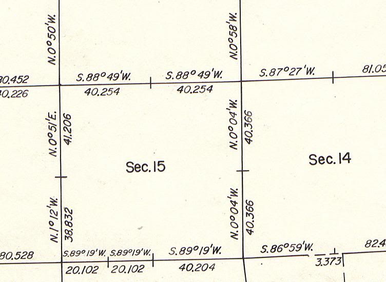
Although it not mentioned in the case, the mathematics point to the west 1/4 corner from the resurvey to be a key factor in the case. Look at how far out it is. The rest of the section (and nearly the entire resurvey plat) is single and double proportion, but the BLM found and held something there. If you do the math, a west 1/4 corner position closer to the middle wouldn't have caused an overlap between the BLM and private surveys. I'm not sure what the BLM found there, because there has never been a corner record filed at Labins.org. I didn't read the thread at RPLS, but I think those are the questions that Keith is looking at, because it has come up before.
Lets see if the Link works:
ftp://146.201.97.137/glo_all/Volume275/Folder%20%208%20pg%2069%20to%20144/2750113.TIF
Nope, couldn't get it link up the picture.
That's a link to the field note page.
Quick Time
It opened.
You may need the plug in for QT
lil hard to read but readable
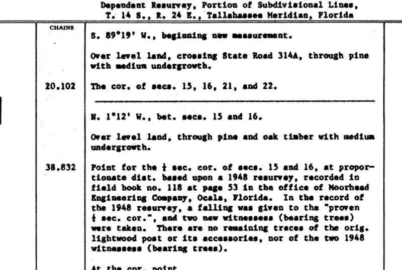
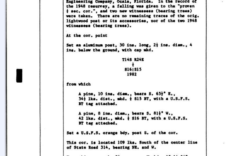
So, if I'm reading that correctly, the BLM ingored a monument reported to be the W1/4 corner which was much closer to the middle of the section line and fell in a state road bed, in favor of another monument which was way off the midpoint and apparently upset this land boundary. Then noted that there was no original evidence to support that decision ...
Damn.
What really gets me is that the overall length of the of the section line is very close to 80 chains, so it doesn't make sense for the 1/4 corner to be off by that much.
Quick Time
If you have quicktime on your computer, it's probably better to right-click the link, do a "save as" to the hard drive, then open the image in a real image viewer.
I hate quick time. It's the most worthless image viewer ever, and Apple integrates it with Itunes so it takes some work to disable it (you can't get rid of it or Itunes doesn't work...)
The resurvey West quarter corner location is certainly the cause for all the litigation. The single proportioned location of the NW Cor SW SW based on the resurveyed W quarter corner was upheld by the court. I don't see any evidence how this can be upheld. (even if it was) There is no evidence given on the resurvey plat that would place the NW Cor. SW SW at a point midway. Look at the south line of section 15 on the plat. On that line there is an indication that the SE corner SW SW is midway. No such notation is made on the west line and no protracted line is drawn on the resurvey plat along the North line SW SW. Yet the court states "In 1982, the U.S. Bureau of Land Management did a "dependent resurvey" of the lands of the U.S. Forestry Service which retraced the lines of the original government survey and identified, restored, and remonumented the original positions of the corners of the original U.S. government survey . This remonumenting of the original government survey, along with the 1986 survey by Whit Holley Britt, made obvious to all the true location of the north line of this quarter-quarter section on the ground and that the Moorhead monuments intended to denote that line were actually located 28.71 feet north of the true location of that line as it was originally established by the official U.S. government survey and reestablished by the 1982 government "dependent survey."
Now then, did the government resurvey make obvious the location of the north line? Hell no!! The 1986 Britt survey did and it was based on a presumption that the NW cor. SW SW is at a midpoint which there is absolutely no evidence to support this presumption on the resurvey plat. The 1986 Britt survey was an illegal independent resurvey. The dependent government resurvey did not even include looking at the line in question or if it did there is nothing on the plat to indicate so. If the government restores original corners of the exterior section line does that effect established interior subdivisional lines? Not in my book. Obviously this side of the argument never showed up in court. Yet in an effort to support its opinion the makes a statement that does not even apply to the facts of this case that "Moorhead was a "following surveyor" and not only fail to properly find the northern boundary of this quarter-quarter section where it was located by the original government surveyor (and also re-established by an authorized federal government resurvey) but to evidence his erroneous opinion as to the true line," So the court places the burden on Moorhead in 1969 to "follow" a 1982 resurvey. So all you protracted line specialists out there make sure and set those corners where the line will be in the future. What a bunch of BS! And yet so may use this case as a benchmark for protracted lines. (IMHO)
I think the court was a little overzealous when they said the government survey "made obvious" the interior section subdivsion. Check out the field note page I linked above. Morehead Eng., who the BLM credits with "proving" the W1/4 they held, actually disagreed with themselves!


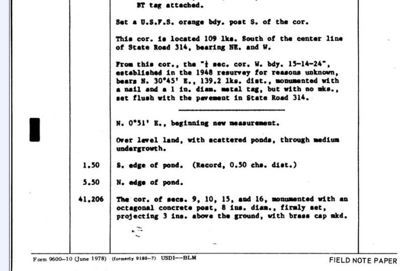
The center of the state road is 6 ft from midway. The "1/4 corner W.Bdry 15-14-24 established for reasons unknown in the 1948 resurvey" is about balls on midway.
Um, you suppose it was established midway? Reasons unknown? How could no one bring this up in court? Nice case to base protracted lines on.
Now we are getting to the facts of this case.
It seems to me that the explanation for the west 1/4 sec. cor. is very shaky and is one reason why I am asking for an explanation of what happened on the ground.
This corner was proportioned???
The interior sec. subd. corners is another story!!
Keith
What's with the tie to the nail that this 1/4 sec. cor. is proportioned to??
What does the phrase "a falling was given to" mean?


