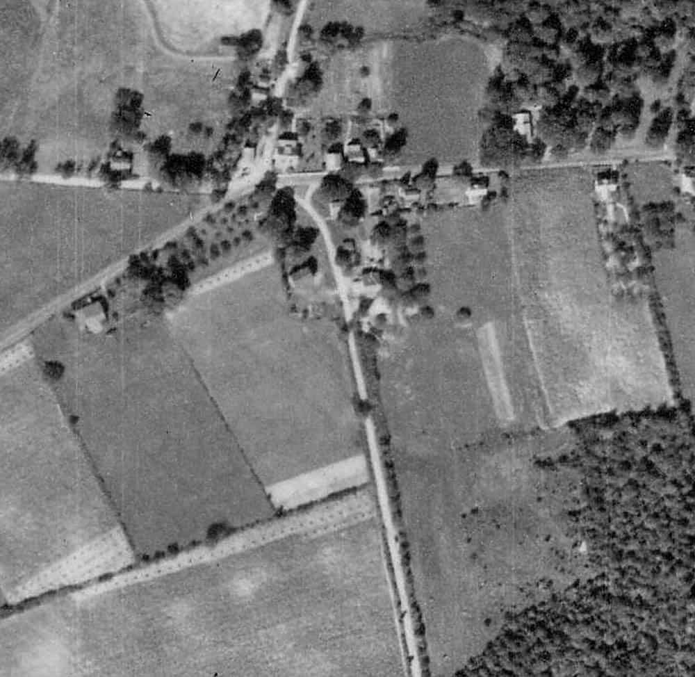
Kent McMillan, post: 444456, member: 3 wrote: Yes, historical aerial photos, particularly when rectified against modern aerial orthophotos, can be extremely useful for making sense of old deeds that refer to vanished or questioned landmarks.
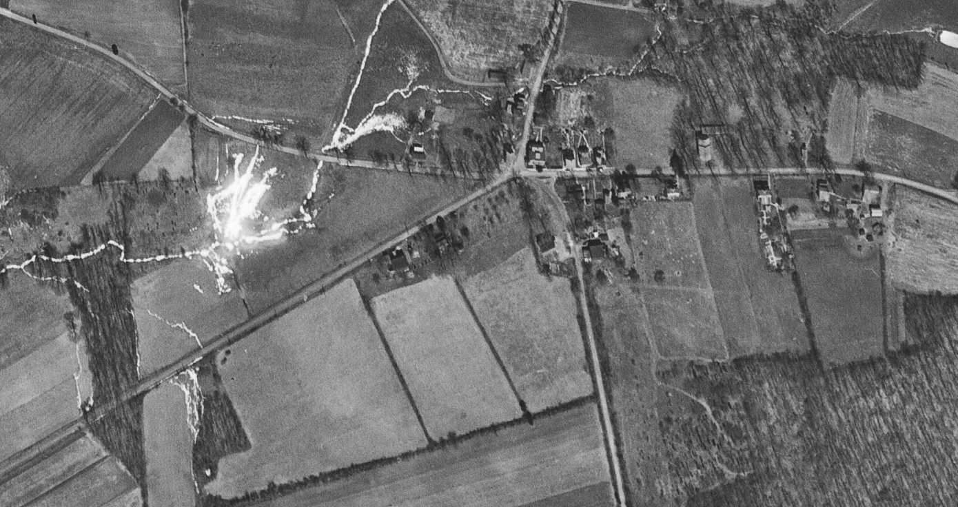
Here is one from April 17, 1968
Dan B. Robison, post: 444461, member: 34 wrote: Here is one from April 17, 1968
The way that I handle similar historical aerial photos in Texas it to download the images from the USGS server (the 1951 image is available for free on line) and rectify them (or some portions of the images surrounding the parcel of interest) in Global Mapper using features that appear in modern high-resolution aerial orthophotos for control. In terrain with lots of photo-identifiable control points, it works quite well.
Another method is to reference the photos in chronological order, and using Global Mapper's translucency tool, create an animation showing the evolution of the use lines.
DDSM
Kent McMillan, post: 444443, member: 3 wrote: I wouldn't necessarily dismiss the idea that the bearings recited in some old deed refer to magnetic North at the date of the survey from which the description was drafted.
Neither would I, but only after (and/or as an aid to) searching for and tying whatever called for monuments there were to be found.
Help!, post: 444388, member: 12997 wrote: when you said make a study of the deeds and predecessors deeds, is this something that I do or the surveyor does? Why I ask is I brought this up with him today and was told I could go to the county and get records if I thought it would be helpful,
This is a very strong indication that the surveyor you hired is not competent to survey boundaries. It is impossible for a surveyor to verify that they are locating the correct boundaries unless they have the proper records to do the job. If the surveyor did not obtain deeds for adjoining properties, they did not have the minimal title research needed to begin.
You descriptions of their actions in your OP also sent up red flags - on site only 3 hrs; phoned in results of prelim field work to office, waited a few minutes then staked positions phoned back from office; conversation with person in office that indicated they treated it like a geometry problem.
As you've probably gathered from all the responses, a boundary survey is an investigative task primarily. The measurements and geometry is merely the means used to relate the positions of the corners as actually found (or actually set in the case of the original surveyor). If the explanation you're getting is all in terms of fitting the dimensions together without discussing any found or searched for physical evidence of the boundary, that's a pretty definitive indication that the person providing the explanation knows nothing of boundary surveying. Worse yet, they probably don't even realize that they are incompetent.
Help!, post: 444388, member: 12997 wrote: He stated that he can't know exactly where our boundaries are without the neighbors deed, so he has to change our deed bearing to fit the neighbors survey. I could understand if this was after finding the landmarks, but this is without finding any landmarks. He agreed that if he had the neighbors deed it would likely come together better, but he didn't have their deed information
What I said above about incompetence as a boundary surveyor fully applies here.
Help!, post: 444388, member: 12997 wrote: Why does this 1982 survey trump my deed?
If your parcel was created as a result of the 1982 subdivision, then any of your boundaries which was an interior line (not on the overall exterior of the subdivided property) would be controlled by the survey of that subdivision. If your parcel shares an exterior boundary with the overall property that was subdivided in 1982, then that subdivision does not trump, or control the location of any of your boundaries.
In the complete absence of any direct evidence of your boundaries, the subdivision might rise to the level of best available evidence of your boundary. That wouldn't mean that the subdivision is somehow more reliable than it otherwise would have been. It would mean that the ground near the actual boundaries, or around any other controlling monument locations mentioned in the deeds would have been so disturbed as to have destroyed any useful evidence such that the surveyor is left with no choice but to resort to the best of the poor evidence that remains.
Judging from the various aerial images posted, and your mention of rocks located in the vicinity of where you would expect your corners to be, I strongly suspect that useful physical evidence (if not the actual corner stones) remains on the ground to locate the true boundaries.
The true boundaries are where they were actually first established on the ground and not where a misguided mathmagician with a survey license thinks they were supposed to be.
Help!, post: 444388, member: 12997 wrote: I run a small business and take delivering on services very seriously. There is no way I would tell my clients- I couldn't figure it out
Some surveying services can be characterized as always being doable even if it might be a challenge to figure out how to get it done. Because of the investigative nature of boundary surveying and the necessity of having to locate boundaries by evidence, there are rare occasions when the information to locate the true boundaries with a reasonable level of confidence is not possible. When and if that is ever the case, the surveyor should be able to clearly, competently, and confidently explain to you what evidence or information is not available, how they exhausted their means to locate the evidence or info, and why that leaves a boundary line or corner location as an open question. They should then be able to advise you on potential avenues to a solution to redefine or to make the location definitive.
But as I said, that level of uncertainty is pretty rare. It is never acceptable to hodgepodge together some guesswork and pass it off as a final professional opinion.
Help!, post: 444388, member: 12997 wrote: Do all surveyors go by landmarks mentioned in the deed or is a grey area?
If landmarks are mentioned in the deed, the surveyor must make a reasonable effort to determine whether or not those marks still exist and if they appear to be undisturbed in their original locations. If found and verified, those marks will control over all other information (a few exceptions that don't need discussion now).
Often, especially in the case of monuments mentioned in very old deeds and in areas where properties have been extensively divided and/or developed, the original monuments will have long since been obliterated. In many of those cases, subsequent surveys will have found a reasonable amount of evidence from the previous survey(s) to have perpetuated the corner where the original monument has been obliterated with reasonable accuracy. So a surveyor needs to search for available survey records to assess whether a monument of a character than what is mentioned in the deed should be accepted as being in the correct position.
Help!, post: 444388, member: 12997 wrote: I'm actually surprised this company is willing to put their name to someone else's survey.
Unfortunately, there are many who are willing to do just that as a way of cutting corners to do a job more cheaply. More unfortunately, there are enough surveyors who do this that many think it is a valid method of boundary surveying.
Help!, post: 444388, member: 12997 wrote: And I'd guess we're up to $800, possibly a $1000. I kind of feel backed into a corner because the survey was admittedly not delivered on and I ether don't pay or pay for something that wasn't done.
After you find and get another opinion from an actual expert who is competent as a boundary surveyor, you may be able to get your money back via small claims, or if you have the time and patience for a civil trial and have actual damages, sue on the grounds of professional negligence.
But be forewarned, $800 to $1000 is what I would expect the fee to be for a lot within a well monumented and fairly recent subdivision. Depending upon the state of available records and physical evidence, I would expect a boundary survey for a parcel like yours to be an absolute minimum of $1000 and possibly several times that. Remember, it's an investigation followed by analysis, not a geometry problem.
Part 2:
Help!, post: 444388, member: 12997 wrote: There was verbal admission of "can't find the deed boundaries, so we're using these other numbers" paraphrasing. Direct quote "I didn't go off your deed, I went by the neighbors survey." So this is why I'm at a loss, we're not wealthy and can't afford to pay for services not rendered.
If you do end up suing this surveyor, there is a very good chance he will end up testifying to much the same thing, although his lawyer might try to help him say it in a way that doesn't sound so blatantly incompetent. If you are able to get a competent opinion from a competent boundary surveyor within 90 days or so, you will have something to counter your first surveyor's claim if he takes you to small claims. Although if you can manage to pay his bill, pay another (far) more competent surveyor and then take the 1st surveyor to court (small claims for a refund or civil if suing for greater damages on the theory of negligence), it would be better. If you fail to pay without a finding of negligence or incompetence by a court or the state licensing board, that first surveyor could do significant damage to your credit rating, possibly place a lien on your property, and possibly prevail in small claims.
Help!, post: 444388, member: 12997 wrote: There are big ole stones planted near the corners. Luckily these are super obvious (and a pain to weed wack so says my husband) Today's surveyor said the stones weren't relevant and to him that the word stone denotes a small 4inch x 4inch rock.
Stones set as corners may have been chiseled into square posts or they may have been of a natural shape in a convenient location and or of a convenient size. If there were any markings placed on the stone by the original surveyor, they will most likely be gone or be very difficult to recognize now. However, there are some well-experienced surveyors who are familiar enough with such monuments to be able to discern marks that are all but invisible to most.
Unless one knows specifically who set the stones, whether they were set or existing natural stones used due to their convenient locations, or the date they were set and well-founded knowledge of a highly prevalent local practice of only using chiseled stone posts of a certain size, I wouldn't put much stock in that statement.
Help!, post: 444388, member: 12997 wrote: My grandfather said contact the title company.
When I started in this business, that would have been an excellent suggestion. Local title companies used to be great sources of relevant documentation and often had title officers who were very familiar with the title and survey history of the area they worked in.
Not so much these days. It is now quite rare and increasingly so as time goes on to find a title officer who is familiar with the local history, much less have more than a cursory familiarity with the records affecting boundaries. Where title officers used to be the preeminent experts in all things related to and affecting title, they are now mostly insurance actuaries having some knowledge of the general principles of title and title documents.
If you don't know specifically what you are trying to locate, dealing with a title company for research is often more frustrating than fruitful. A knowledgeable surveyor would be able to get the useful documentation from a title company easier than a homeowner normally would because the surveyor should know specifically what to request.
Help!, post: 444388, member: 12997 wrote:
This is turning into a full time job, but losing money instead of making it!
I'm embarrassed for my profession to say it, but that's the effect when a poorly performed survey is discovered. The silver lining for you is that this one was performed so poorly that the results don't even seem within the realm of reason. Most poor boundary surveys go undiscovered for many years or decades because the results seem like they could be reasonable to the untrained, or sometimes because landowners simply don't have the resources to have it redone properly and so decide to live with results they don't think are right but aren't so wrong as to make worth the cost of fighting.
The unfortunate reality within our profession is that there are a great many licensed surveyors who don't recognize what the actual job of boundary surveying is, and so treat it as if it is like many other areas of survey practice that are better characterized as practical applications of engineering problems. That is, they think it is another task that only involves solving a math problem and making the measurements to apply the math solution to the ground. The field measuring methods and math involved in most boundary surveys is relatively simple as compared to other surveying that they think of boundary surveying as simple. They don't even recognize the real goal (to find the boundary as actually first established on the ground) and so don't recognize the actual tasks of investigation and analysis of evidence.
Help!, post: 444388, member: 12997 wrote: I was told the bearings MAY be magnetic because of the deed age. The reason I think they are is...
It's a very good possibility that they are. Kent gave you a link to the NOAA historic magnetic declinations page. There is a calculator on or linked to that page, and he also gave you the results showing the time-specific mag dec at your location (I found your parcel at the same latitude and longitude as he did) up through the early 1800s.
The calculator also provides the rate of change on the specified date. As you can see from the data Kent provided, not only does the magnetic declination change with time, but so does the rate of change. It's quite likely that both triangle descriptions are described in magnetic bearings and are accurate for the time the measurements were made, and that they were made 30 to 50 years apart.
However, the bearings and whether or not they are magnetic only becomes important if there is insufficient physical evidence to place one or more corners and sufficient evidence to locate one or more of the others.
Help!, post: 444388, member: 12997 wrote: I didn't go with the lowest quote- or the highest. Right in the middle.
Although cost may be an indicator of expected quality, it is not always so. It may be the highest is from a large engineering company with high overhead and/or a company that doesn't really want to do the job but will if paid enough. It could also be that one of the lower quotes comes from a semi-retired surveyor who works out of his garage or spare bedroom and takes on just enough work to stay busy because he really enjoys the work. That might be the person with the best and most experience.
Generally though, the best person for the job will have a fee estimate close to or at the top end of the pool if you get several estimates. He or she will know what their work is worth. The best surveyor for the job may be a sole practitioner or may work for a larger company. Most likely they will be a sole practitioner or work at/be sole or part owner of a very small company.
Help!, post: 444388, member: 12997 wrote: I contacted a second survey company, but now am nervous that I'm going to have a very expensive repeat of today.
Use the responses in this thread to develop questions to interview surveyors to figure out who you should go with. Find the right surveyor then get the estimate. Don't let price guide you as going with the cheapest is almost always the worst choice, and going with the most expensive solely on the idea that you get what you pay for could be misleading.
Some have suggested getting a recommendation from a local attorney. The problem with that is that finding an attorney who has enough knowledge in boundary matters to be able to know and recognize a highly competent boundary surveyor can be more challenging than finding such a surveyor on your own.
Help!, post: 444388, member: 12997 wrote: Also, what are your thoughts on magnetic north? Can I find more info at the county office?
County won't be much help. If you want to satisfy your own curiosity, follow the link Kent provided. Otherwise, when you speak to other surveyors, be sure that you get a level of comfort that he or she will be diligent and thorough not only about considering magnetics, but in all areas of research and field investigation as well. Also make sure you hire someone who won't mind taking the time to explain their results to you.
Help!, post: 444388, member: 12997 wrote: I'm thinking of just offering to buy 15 feet of the neighbors land so we don't have his yard trash stacked up out the back door. I don't know if he'd accept. Stubborn.
If your neighbor is the type to put you on notice by building a brush pile next to your house, this is probably a non-starter. Get trustworthy survey results before deciding any next steps.
Help!, post: 444388, member: 12997 wrote: Both of our lots have very old deeds dated back to the 1800s and written in perches.
[SARCASM]Have yours rewritten in pikes to make it more powerful.[/SARCASM] (stupid fisherman humor. Sorry, couldn't resist.)
Evan Page's analysis is absolutely spot on.
eapls2708, post: 444550, member: 589 wrote: a boundary survey is an investigative task primarily.
Evan said that in so many good ways. I'm glad to see you getting solid counsel.
N
eapls2708, post: 444551, member: 589 wrote: If you do end up suing this surveyor
As you can see, boundary issues can be complex and esoteric. Explaining the problem with boundary establishment in court is a crap-shoot: you never know what the courts will understand, what they'll hold, and how their ruling will fall. You could end up being responsible for costs in excess of the value of the land AND be held to a worst-case scenario boundary.
Exhaust all options to work this out without going to court before considering that option - it's rarely beneficial to either party.
You may be correct in your assertion (and the findings of an expert boundary surveyor) but once it's in the hands of the courts - validity, correctness, and the quality & weight of evidence may be lost in the complexity of the case (especially when spun by a skilled litigator) and may not be properly considered in the findings - sometimes the ruling magistrate/judge doesn't understand boundary law and they may rule in a manner that is at odds with the facts.
IF you do get a survey that supports your position - be sure to file a Record of Survey (ROS) (or the PA equivalent if they don't have one) to perpetuate those findings and reduce the potential of a contrary location being asserted. If the surveyor includes the rationale for their findings on the ROS, it is more likely to be adopted by other surveyors and, over time, may ripen into accepted evidence of location.
Because of what JKinAK said, one of the most important traits you should be looking for in a surveyor is both a willingness to explain how they arrived at their results and the ability to express complex technical and legal principles in non-technical, easy to understand terms.
Some surveyors don't like to explain anything to anyone. Still others can clearly things across to another surveyor, or at least to someone who can follow a technical explanation. A surveyor who is comfortable with and capable of explaining the complex in simple terms is one who is very likely to be highly competent as well as confident in their knowledge, and is also not common.
Help...
If it is available post the 1982 'subdivision' survey...it may prove that THAT surveyor knew his boundary retracement and made notes of his historic findings...maybe he had it figured out back 35 years ago.
Your surveyor might have been tying into Mr. 1982 and 'following' HIS footsteps as the BEST AVAILABLE EVIDENCE....
Or maybe not...
What does Arkansas know about PA surveying??
DDSM
John Hamilton, post: 444454, member: 640 wrote: I am not an expert boundary surveyor, but my experience with my own property (western PA) is that the bearings are often "true" north, observed with a magnetic compass and then corrected for declination (sometimes very different values determined in the field). And it is very common in PA for adjoining deeds to be on a totally different basis of bearings, and even in different versions of the same deed. For example, here are two of the earliest deeds for my property, and a later one (1920's) note the different bearings and distances for the same lines:
DB 29: 1/18/1822 Douglas to Douglas
Beg@Black Oak
Thence by Donalson N76E 194 perches to a post
Thence by Douglas N47.75W 103 perches to a post
Thence by Douglas S65W 153 perches to a post
Thence by Gillespie S23E 57 perches to POB 75 acresDB 271: 4/8/1871 Douglas to McCrory
Beg@Black Oak
Thence by Donalson N78?ø54??E 196 perches to a point in center of a road
Thence by Douglas N45?ø22W 102 perches to a post
Thence by Douglas S68W 149.9 perches to a point
Thence by Gillespie S20E 56.56 perches to POB 78acres+1 perchDB 2148: 3/19/1923 Fife to Jury
Beg@iron pin
Thence by Donalson S80?ø43??30?W 3246.45 ft to a large black oak
Thence by McConnell and Espy N18?ø12W 938.98 ft to a stone
Thence by Baldesberger N69?ø49??E 2479.02 to a stone
Thence by Erbe S43?ø41??E 1693.54 ft to POB 78.74 acresDoesn't even seem like the same property, but it is.
One suggestion I might make is to approach the neighbor in a friendly manner, you are not the one he had the dispute with, and say that you are wondering where all the confusion is coming from, maybe an amicable solution can be achieved.
Your parcels were likely part of the same parent parcel as the adjoiner. If so, then the date(s) when the larger parcel was divided into smaller pieces is important, due to junior/senior rights.
Did you switch "938.98" in the second course with "1693.54" in the fourth course?
Either way, I have good news, every time it's surveyed your property gets bigger! 😉
Good job Kent.
I think it is becoming clear that the true line is probably rather close to the old school building.
John Evers, post: 444644, member: 467 wrote: Good job Kent.
I think it is becoming clear that the true line is probably rather close to the old school building.
Yes, that's where I'd put my money.
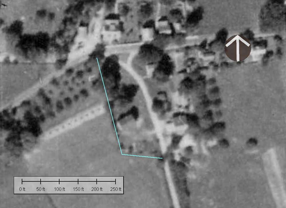
Here's the 1937 image after rectification:
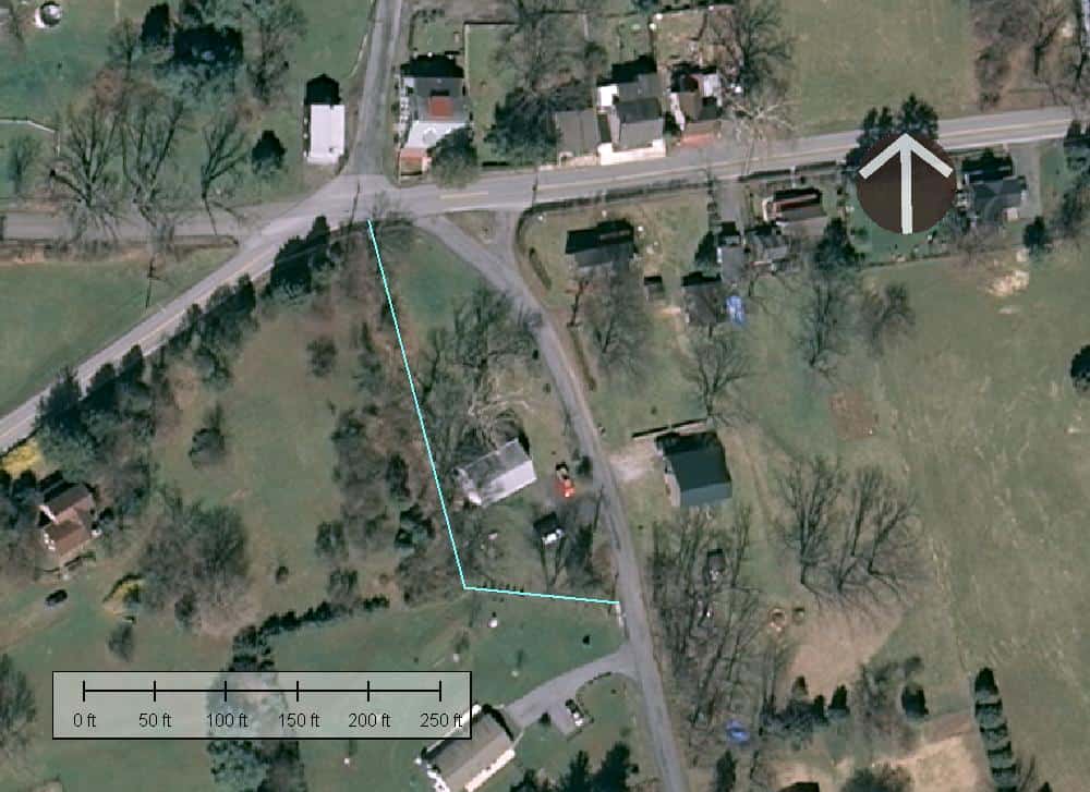
and the same linework overlaid on 2010 imagery (I think it is).
and as a rough first approximation of the bearing basis used in various early surveys, the true bearings of the South and West lines of the parcel as drawn from the evidence of occupation that appears in the aerials scale as:
N84-3/4?øW and N13-1/4?øW


