The other day someone - I can't recall who - was wondering how a surveyor determines the center of a rock mound of the sort similar to what was placed by Texas surveyors in, say, 1875 in Travis County, Texas to mark corners of land grants made by the State of Texas.
Here is an example from this afternoon's work as the reconstruction of certain key elements of the complex patchwork quilt of land grants made by the Republic and State of Texas between 1839 and 1939 in the Hill Country near Austin continued.
This rock mound was made on December 10, 1875 by Travis County Surveyor John E. Campbell to mark a corner of a certain 80 acre tract of land that one Frederick Kleineman had applied for as a homestead preemption grant under the terms of the law enacted in May of 1873 providing for grants to be made to actual bonafide settlers of vacant, unappropriated lands in the public domain.
Mr. Campbell was the same surveyor who in 1879 made the rock mound that I posted photos of yesterday.
I guess that in 1875, Mr. Campbell never suspected that a barbed wire fence would be built to enclose the adjacent tract or that a 6-inch dia. cedar corner post would end up approximately 9.0 ft. distant from where he made his mound. Otherwise, I'm sure he would have shifted his mound over a bit more than 3 varas in order to hit where the fence would be so that there would be no confusion. But he didn't and the mound has evidently survived in essentially perfect condition for 142 years.
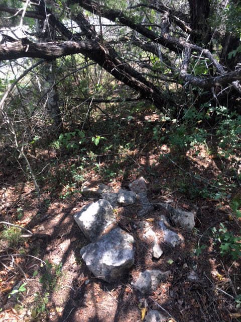
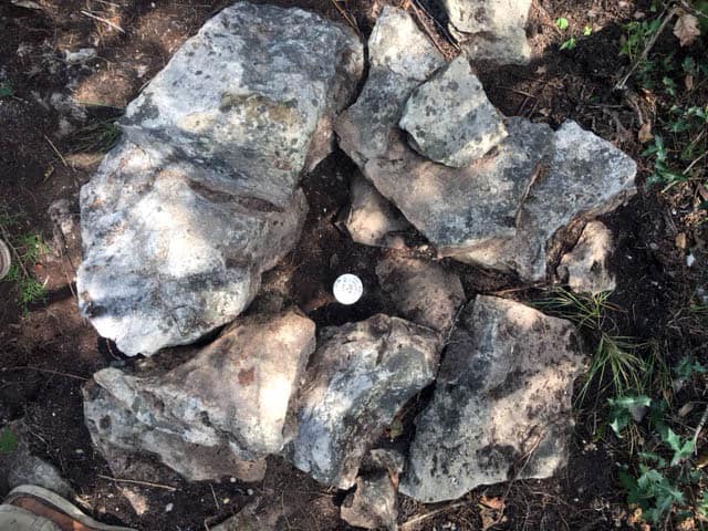
Here is a photo of the mound as I first saw it, an obvious rock mound hiding under a thick layer of cedar (Ashe juniper) duff.
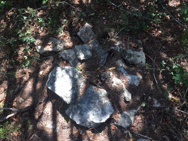
The first order of business was to use a whisk broom to clean off the duff and expose the size and pattern of the stones making up the mound..
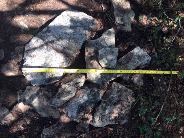
The mound was 2.7 ft. in diameter both ways if one disregarded a couple of stones that had evidently slid from the mound into positions in which it was unlikely they were originally laid.
By extremely advanced mathematics, I was able to compute that the center of the mound should be about 1.35 ft. from its edges. That point hit in a position around which the stones formed a radial pattern, so it was perfectly plausible as a candidate for the center of the mound.
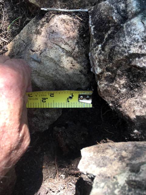
The metal detector indicated no ferrous survey marker was already in the mound designating its center, so I got the rock drill out and positioned the bit at the center of the mound that advanced mathematics had determined. Once the drill was fired up, I placed the bit in the position of the center and promply sank the bit about 18 inches into ground that is otherwise very rocky. I'd hit the hole of something at the center of the mound.
Closer inspection revealed that my choice of the center coincided with where the remains of a very old and very rotten cedar stake that probably had originally been about 2 or 3 inches in dia. were.
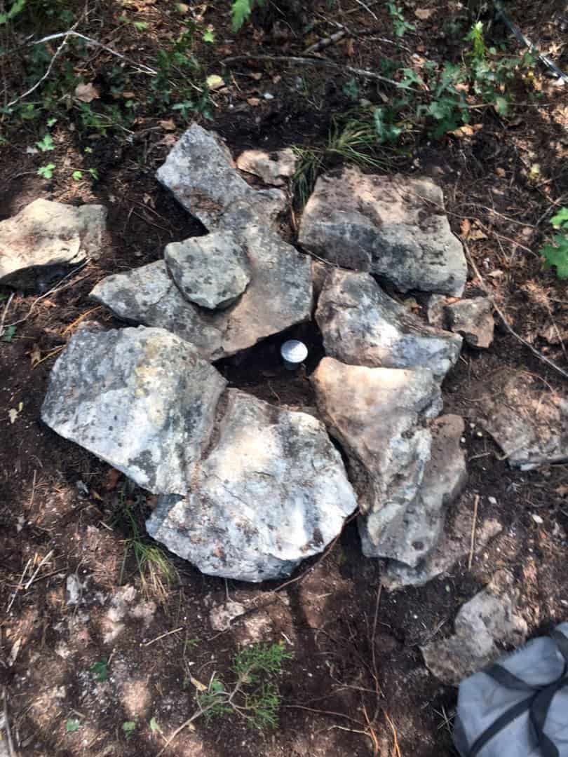
So, I pulled the rotten cedar stake and set my new rod and cap, REASONABLY CERTAIN that my designation of the center of the rock mound was within less than 0.10 ft. of corner as marked in 1875.
And after returning a large upper stone to about the position in which I found it:
The fence corner post was still about 9.0 ft. away.
I don't see any better center than that
warren ward PLS CO OK, post: 440212, member: 12536 wrote: I don't see any better center than that
'til he calcs it all out and realizes there's a 6 second PI in a line that was purported to be "straight"....
Trust in Kent. His OCD will eventually get the best of him and he'll wind up setting another 0.27' from the first one. 😉
warren ward PLS CO OK, post: 440212, member: 12536 wrote: I don't see any better center than that
The cedar stake remains were more of a confirmation of the method. In this case it worked very well since the mound was nearly completely intact. When the mound is partially fallen or scattered and there are no bearing trees or other means to fix the corner any better than the blurry evidence presented by the mound, it becomes more of an art.
paden cash, post: 440215, member: 20 wrote: 'til he calcs it all out and realizes there's a 6 second PI in a line that was purported to be "straight"....
Trust in Kent. His OCD will eventually get the best of him and he'll wind up setting another 0.27' from the first one.
I'm almost certain that you're confusing the standard practices of PKLSSia with Texas.
The corner is the corner here and, without any any better evidence of the corner, the rock mound called for by Mr. Campbell in his field notes controls the boundary of the grant as surveyed by him. You're (probably unintentionally) correct that it does not control the boundaries of the senior grant it may be in the vicinity of.
Kent McMillan, post: 440209, member: 3 wrote: This rock mound was made on December 10, 1875 by Travis County Surveyor John E. Campbell to mark a corner of a certain 80 acre tract of land that one Frederick Kleineman had applied for as a homestead preemption grant under the terms of the law enacted in May of 1873 providing for grants to be made to actual bonafide settlers of vacant, unappropriated lands in the public domain.
[snip]
The mound was 2.7 ft. in diameter both ways if one disregarded a couple of stones that had evidently slid from the mound into positions in which it was unlikely they were originally laid.
By extremely advanced mathematics, I was able to compute that the center of the mound should be about 1.35 ft. from its edges. That point hit in a position around which the stones formed a radial pattern, so it was perfectly plausible as a candidate for the center of the mound.
The metal detector indicated no ferrous survey marker was already in the mound designating its center, so I got the rock drill out and positioned the bit at the center of the mound that advanced mathematics had determined. Once the drill was fired up, I placed the bit in the position of the center and promply sank the bit about 18 inches into ground that is otherwise very rocky. I'd hit the hole of something at the center of the mound.
Closer inspection revealed that my choice of the center coincided with where the remains of a very old and very rotten cedar stake that probably had originally been about 2 or 3 inches in dia. were.
So, I pulled the rotten cedar stake and set my new rod and cap, REASONABLY CERTAIN that my designation of the center of the rock mound was within less than 0.10 ft. of corner as marked in 1875.
So, based on your narrative aside, Travis County Surveyor Campbell made a stone mound in 1875. Did his field notes state something akin to his 1878 field notes (the notes with the mystery word you took to be "faul") that he "set stake [for cor] (imperative mood)"? If so, did his notes state that the stake was surrounded by a mound of stone, 3 ft. at the base? Or did his notes just mention that he made a stone mound on Dec. 20, 1875?
Should the stake not be called in the 1875 notes, I assume that you rejected the cedar stake as not marking the corner and then carefully followed the procedure outlined in your OP. In this case, will you classify the stake in your narrative aside as a coarse attempt to perpetuate the corner, or just a previous retracement surveyor's attempt to let others know that he had been there?
I humbly acknowledge that you work in a, "complex patchwork quilt of land grants made by the Republic and State of Texas between 1839 and 1939 in the Hill Country near Austin". Here in the PLSS State of Colorado, when the field notes state, "set stake for cor", then the corner is marked by the stake and any mound of stone is classified as an accessory to the corner. In the notes of my plat, I would clearly state that the rotted remains of the cedar stake is the best available evidence for the corner and I would drive a 30" long, No. 6 rebar through the center of the rotted stake remains and affix an aluminum cap stamped with the corner information. I would not pull the cedar stake so that future surveyors will be able to verify the basis for the placement of my monument. But then again I work in an easy-peasy PLSS state where a large portion of the metes-and-bounds surveys are simple rectangles otherwise known as mineral surveys.
Sounds like you got lucky hitting the remains of the stake, but the process seems a little backwards. Maybe you should have first probed around for the stake and THEN set your rebar. Kinda like the other one where you first set a rebar, and THEN looked for the bearing trees.
This is a tough neighborhood. Best keep your switchblade handy.
What did you stamp the cap? FND STK & RK MD? (& customary point #, I assume).
Gene Kooper, post: 440222, member: 9850 wrote: So, based on your narrative aside, Travis County Surveyor Campbell made a stone mound in 1875. Did his field notes state something akin to his 1878 field notes (the notes with the mystery word you took to be "faul") that he "set stake [for cor] (imperative mood)"? If so, did his notes state that the stake was surrounded by a mound of stone, 3 ft. at the base? Or did his notes just mention that he made a stone mound on Dec. 20, 1875?
One of the features of surveying in Texas is that you inevitably deal with the work of many surveyors who built up the pattern of land grants over time and part of the exercise is understanding their record. In the case of this grant, Mr. Campbell's call was for "a Stone mound from which two Spanish Oaks brs. N 28 E 16 vrs". As a rule, he did not describe the stone mounds he made in any detail and was quite sparing in his mention of bearing trees. However, if it clear from other evidence that he actually did build stone mounds where he called for them and run the lines of a survey even though the mention of passing calls on terrain were few and far between. Mr. Campbell was the Travis County Surveyor in 1875 and did correctly anticipated that another surveyor would not be working in the area for years, so apparently it was enough for him that he would recognize the corners he marked and the lines he ran.
The remains of the stake were unexpected because the call was for "stone mound" rather than "stake and stone mound", but I consider that to be simply Mr. Campbell's taste for brevity at work.
Should the stake not be called in the 1875 notes, I assume that you rejected the cedar stake as not marking the corner and then carefully followed the procedure outlined in your OP. In this case, will you classify the stake in your narrative aside as a coarse attempt to perpetuate the corner, or just a previous retracement surveyor's attempt to let others know that he had been there?
No, it was clear to me that the mound had been built around the stake. The fact that the cedar stake was as completely decayed as it was, indicated to me that it probably wasn't dry heart cedar when set, but was more likely something cut green nearby. The question really boils down to: "Which came first, the stake or the mound?" My opinion is that the stake came first and that the mound was laid up around it as a center. So the center and the hole left by the stake as it rotted away are identical.
I humbly acknowledge that you work in a, "complex patchwork quilt of land grants made by the Republic and State of Texas between 1839 and 1939 in the Hill Country near Austin".
Yes, that's certainly true and for the obvious reasons.
Andy Nold, post: 440277, member: 7 wrote: What did you stamp the cap? FND STK & RK MD? (& customary point #, I assume).
No, the cap was stamped "KENT MCMILLAN, SURVEYOR, 224, FD OLD SM, RPLS 4341". The existence of the decayed cedar stake was not an essential part of identifying the corner that the original surveyor reported as "stone mound" in 1875, although I'll mention it in the metes and bounds descriptions yet to be prepared.
roger_LS, post: 440266, member: 11550 wrote: Sounds like you got lucky hitting the remains of the stake, but the process seems a little backwards. Maybe you should have first probed around for the stake and THEN set your rebar. Kinda like the other one where you first set a rebar, and THEN looked for the bearing trees.
Not really. Most of the cedar stakes that I've found in rock mounds were visible in the mound, sticking up at least 12 inches. Ashe juniper heartwood is very rot resistant if cut and dried and the commonest stake that I find appears to have been cut from a dead branch that is nearly entirely all heartwood. The state of decay of that stake was unusual and had left the stake so reduced as to be as nearly invisible as the Spanish Oak bearing trees Mr. Campbell mentioned. Those would have been bulldozed out more than sixty years ago when a road was constructed.
The significance of the highly decayed cedar stake and the absence of any steel marker was that this mound had probably not been recovered by a surveyor any time in the last century.
Kent McMillan, post: 440278, member: 3 wrote: .."The remains of the stake were unexpected because the call was for "stone mound" rather than "stake and stone mound", but I consider that to be simply Mr. Campbell's taste for brevity at work...."
I run into that a lot. At one corner recently I read the 1872 GLO notes stated "buried a quart of charcoal" before setting a wooden post for a corner. I found a 3/8" piece of rebar with some weathered flagging that was almost obviously set by the original crew. I came to the same conclusion as you; the omission was merely a "taste for brevity" in the recording of the occasion in the notes.
paden cash, post: 440281, member: 20 wrote: I run into that a lot. At one corner recently I read the 1872 GLO notes stated "buried a quart of charcoal" before setting a wooden post for a corner. I found a 3/8" piece of rebar with some weathered flagging that was almost obviously set by the original crew. I came to the same conclusion as you; the omission was merely a "taste for brevity" in the recording of the occasion in the notes.
So, you didn't have a fence corner to use instead?
[USER=3]@Kent McMillan[/USER] I'm curious what you use for 'lesser measurements'?
I see you have a steel tape in feet and tenths.
I Googled but couldn't find anything useful.
Below Vara, what do you use. 1/10ths? And why not have a 'Vara' steel tape?
Stoned corners are getting a rarity here. Logging the back blocks, and farming of long ago put them on the endangered list.
Richard, post: 440286, member: 833 wrote: [USER=3]@Kent McMillan[/USER] I'm curious what you use for 'lesser measurements'?
I see you have a steel tape in feet and tenths.
I Googled but couldn't find anything useful.
Below Vara, what do you use. 1/10ths? And why not have a 'Vara' steel tape?
Stoned corners are getting a rarity here. Logging the back blocks, and farming of long ago put them on the endangered list.
The 19th-century surveyors used the units of varas for reporting distances between boundary corners and widths of waterways crossed by a survey line, the reason for the latter being that any waterway wider than 10 varas was considered to be navigable by law, if not in fact.
Below that scale, tree diameters were nearly universally expressed in inches and heights of things in feet. "Rock mound 6 ft. tall, 3 ft. dia. base" would be an example of how some stack of rocks that probably didn't remain that way for more than ten years was described.
I carry two pocket tapes, one, graduated in the French units, for measuring the heights of GPS antennas and one graduated in feet for measuring everything else under 20 ft. distant. In the case of the 6 in. dia. cedar fence corner post that the 1875 surveyor probably would have built his rock mound in the position of - had he only known of its future existence - I'll get a tie to the center of the post when I make the tie to my rod and cap from a control point in the clear. I'll compute the distance from the post to the rod and cap, reciting it as as "approximately" so many feet rounded to the nearest tenth of a foot when I draft the metes and bounds description. The purpose of the tie is merely as an aid to future recovery, not for location. Accurate State Plane Coordinates will be the best basis for replacing the corner if it is abducted by aliens after 142 years.
Thanks Kent
Expect living with it I expect it's second nature to deal with actually using several sets of units of measurements as opposed to rubbing shoulders with them in reviewing and using old surveys in links, chains and feet.
Keeps us on our toes.
Richard, post: 440289, member: 833 wrote:
Expect living with it I expect it's second nature to deal with actually using several sets of units of measurements as opposed to rubbing shoulders with them in reviewing and using old surveys in links, chains and feet.
Keeps us on our toes.
Yes, working around inches, US Survey Feet, Texas Varas, and the odd meter or kilometer not really a problem when one deals with all on a regular basis and has internalized some basic conversions such as:
1900.8 varas = 1 mile = 5280 ft.
1.61 km = 1900.8 varas mas o menos = 1 mile
36 varas = 100 ft. = 30.48m
Kent McMillan, post: 440278, member: 3 wrote: One of the features of surveying in Texas is that you inevitably deal with the work of many surveyors who built up the pattern of land grants over time and part of the exercise is understanding their record. In the case of this grant, Mr. Campbell's call was for "a Stone mound from which two Spanish Oaks brs. N 28 E 16 vrs". As a rule, he did not describe the stone mounds he made in any detail and was quite sparing in his mention of bearing trees. However, if it clear from other evidence that he actually did build stone mounds where he called for them and run the lines of a survey even though the mention of passing calls on terrain were few and far between. Mr. Campbell was the Travis County Surveyor in 1875 and did correctly anticipated that another surveyor would not be working in the area for years, so apparently it was enough for him that he would recognize the corners he marked and the lines he ran.
The remains of the stake were unexpected because the call was for "stone mound" rather than "stake and stone mound", but I consider that to be simply Mr. Campbell's taste for brevity at work.
No, it was clear to me that the mound had been built around the stake. The fact that the cedar stake was as completely decayed as it was, indicated to me that it probably wasn't dry heart cedar when set, but was more likely something cut green nearby. The question really boils down to: "Which came first, the stake or the mound?" My opinion is that the stake came first and that the mound was laid up around it as a center. So the center and the hole left by the stake as it rotted away are identical.
Yes, that's certainly true and for the obvious reasons.
Kent, what a bunch of gobbledygook! If the the cedar stake was the corner, then this thread is NOT an example of "Finding the Center of an 1875 Rock Mound". Out of all the stone mounds that you have rehabilitated over the years, you pick one where the corner is actually a wood stake with a mound built around it, rather than the scattered remains of a pile of rocks. Not only is it not an example of the thread title, you actually destroyed the original evidence of the corner set by Mr. Campbell by pulling the rotted remains of the cedar stake and apparently giving it a good heave.
Your justification for the destruction, well you didn't provide one. You only provided some glib narrative aside that the stake was obviously not, "dry heart cedar". Why would that even matter to a retracement surveyor. Who cares that the stake has rotted in the last 142 years. The position of that rotted stake is still recoverable, or at least was until you decided to do some Cadastral housekeeping!
As for your allegation that surveying in Texas is so complex, the only thing that I've seen about the complexity of your work is your convoluted logic being substituted for complexity. In this thread, you defend the destruction of evidence. In an earlier thread, you defended your practice of carefully placing the stones with the patinated sides up for situations where you believe rebuilding the stone mound is appropriate. Your reason? To give the appearance that the mound was NOT recently rebuilt. That, and for the children (that being young surveyors that may never see an undisturbed original stone mound will know what they look like through your simulated aging method).
I honestly find these explanations to be beyond absurd, esp. in light of your notion that Texas surveys are so complex for "the obvious reasons". I'd be in agreement if you substituted "absurd" for "obvious".
obviously...;)
