I figured it would be more rigorous if there was no "eccentric"component, just straight vertical shot.
John Hamilton, post: 441146, member: 640 wrote: I figured it would be more rigorous if there was no "eccentric"component, just straight vertical shot.
Easier to document and check I suppose
I have done this many times before; a long time back. The last time was in a 75 foot vertical shaft and I used a 100 foot calibrated
tape done at NIST and 2 different EDMI. One EDMI was the Kern Mekometer ME5000 the other was a Sokkia Set 3.
The spread between all three (tape and the 2 EDMI was 0.002 foot.
What I would like to know is what accuracy are you looking for?
What is the width of your access hole in your picture?
JOHN NOLTON
PS nice pictures
Yea, I wish I had a Mekometer to play around with...I did use a 3000 model
My guessestimate would be 3' X 3'. The required accuracy is not specified. Here is a little history...
We do settlement surveys in three parts, east dam, west dam, and in the air gallery in between. After Katrina the Corps had a requirement called CEPD (Comprehensive Evaluation of Project Datums) where each project is to have a PPC (Primary Project Control) station in the NSRS. Most of the navigation projects (located along the rivers where existing USCGS/NGS level lines exist) were done by bluebook levels (although the Allegheny River locks were done by GPS). The sixteen reservoirs were done with GPS (bluebooked) because in most cases the distance to existing level lines was too far to run economically. So, we did a bluebook survey of all sixteen reservoirs in 2008. It was not all new data, we had been doing GPS at each project off and on since 2005, but there was quite a bit of new lines measured to benchmarks, HARN, etc.
So, this project has a PPC station which is a triangulation station set for the project in 1935 in the parking lot of the project office. We run levels from that point down to the east dam every year. Then we run the air gallery loop and the west dam loop each individually, no connections between them.
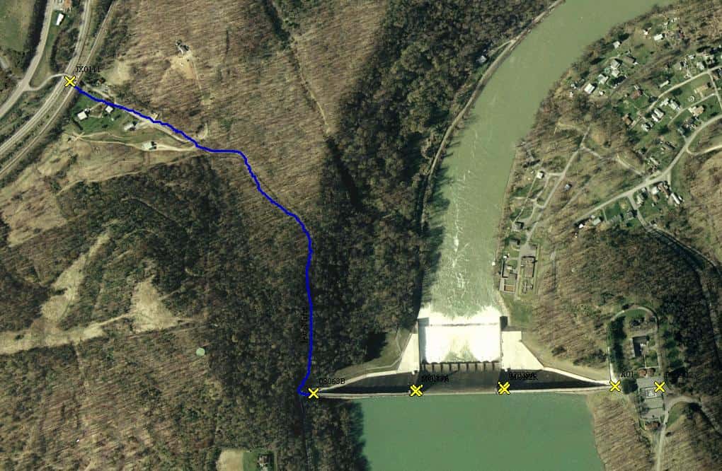
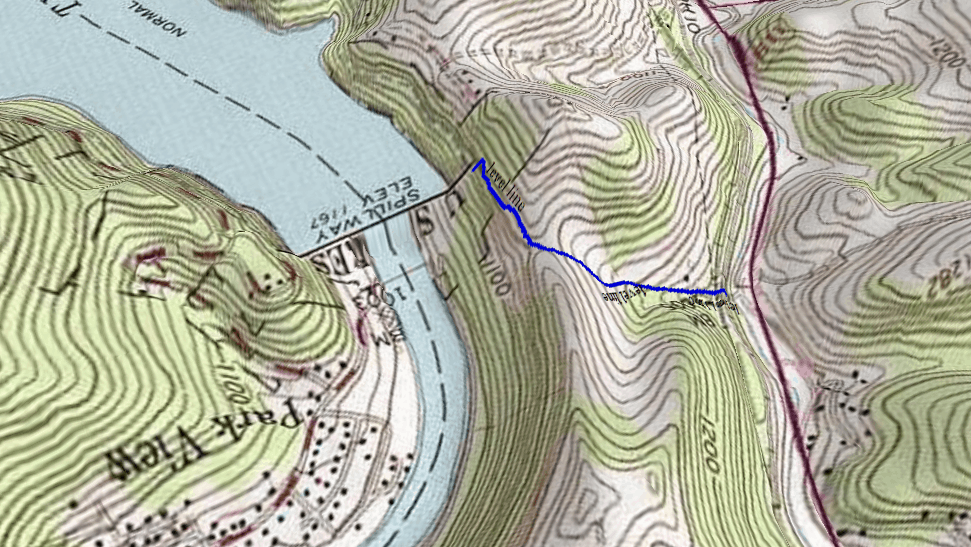
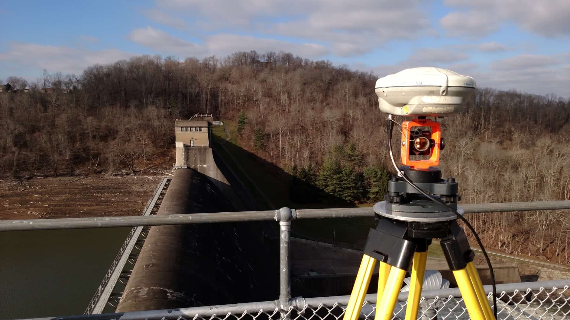
This project does have an existing benchmark about 1 mile west on a massive railroad abutment (relocated railroad, all of the old marks are now under the lake). So we decided to run from that mark up to the west dam. It was a run through the woods, up a large hill (through a saddle) and back down to the dam. We first ran it with the standard 4 m wooden rod, did not get a good closure, so we re-ran it with a 3 m invar rod. 6.8 mm over 1.7 km, just barely met second order class I. Here is a picture taken from the roof of the east tower looking towards the west tower showing the woods we ran through.
Here is the level run overlaid on an aerial...
on the USGS quad:
Then we decided to try and connect to the PPC, which meant going through the air gallery. The steps down to the air gallery were not conducive to running levels...
So we did the tie through the shafts. Coincidentally (or maybe not) the elevation differences from alignment disks on the surface at each tower to the alignment disks in the air gallery were the same to the mm on both sides, -12.113 meters.
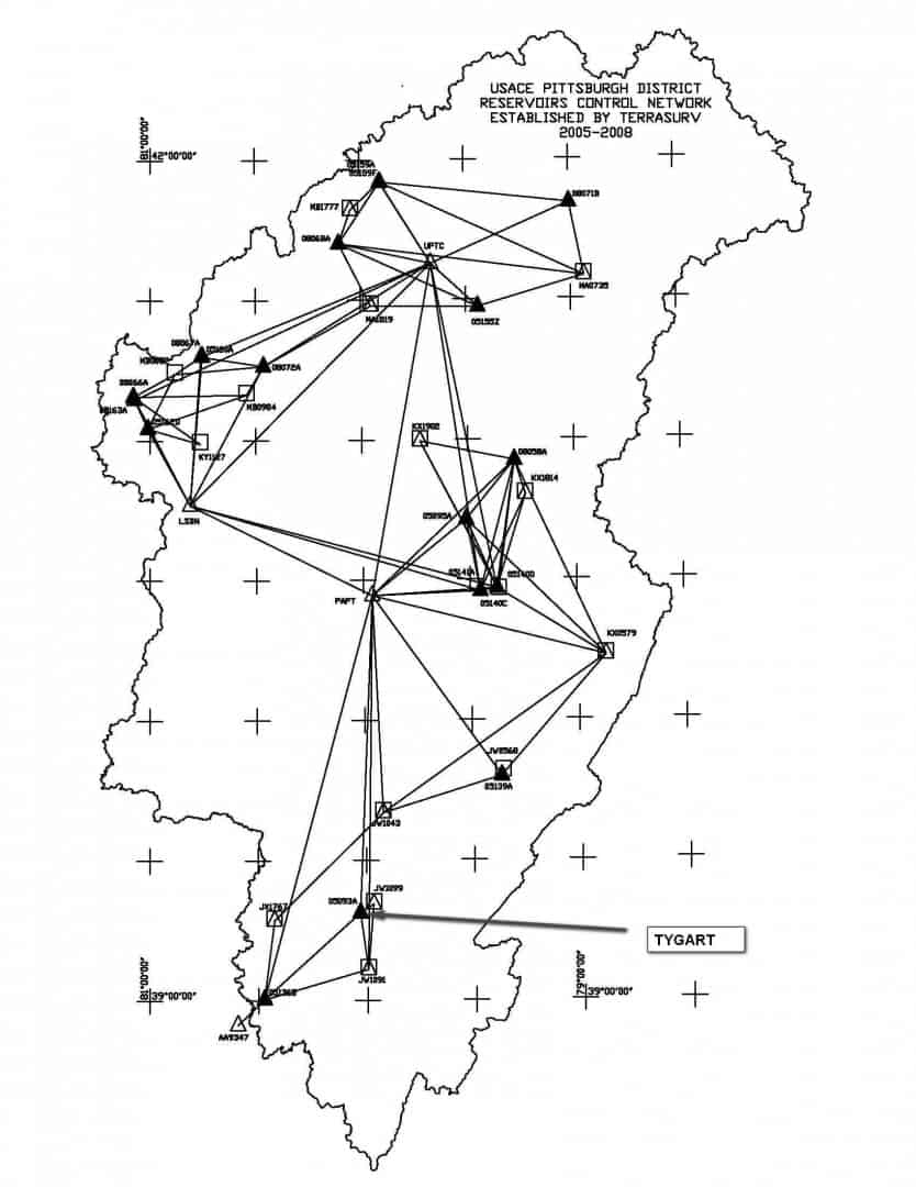
After adding it all together, the GPS derived orthometric height at the PPC had a misclosure of 0.012 m versus the level run from the NSRS benchmark. So that helped to validate the bluebook survey we did of the reservoirs, which is shown in the map below. That project was supposed to attain ?ñ0.03 m for all of the PPC stations at the reservoirs. For scale, the district (shown by the squigly line) covers 26,000 sq miles.
A Bureau of Reclamation surveyor came up to me in the hotel parking lot this week (he was confused why a firefighter had a truck full of surveying equipment), they are doing a big static survey on the Friant-Kern Canal (Tulare County) because it subsided 2' in a couple of years. He said DWR (CA Dept of Water Resources) had questioned their data because their survey wasn't matching Bureau of Rec surveys from a few years before. So now they are trying keep up with the subsidence. I'm not a firefighter, I just wear the blue uniform because it opens doors, gates, amazing the places I can go just for asking.
John Hamilton a couple more questions; In the next to last picture you show a person climbing the steps up from the air gallery,
is there no way to trig level to the bottom at that location?
Your last picture; in that district how many dams do you have?
How good was the GPS control for that district?
JOHN NOLTON
John Nolton: Trig levels would be a possibility. Maybe. However, there are several short segments with 90?ø bends (I think there are 4 or 5 turns on the way down if I recall, and access from the steps in to the tunnel is very short. There is a rectangular opening that he is crouching down to go through, and the tunnel is on the other side.
There are 16 reservoir dams (and 23 navigation locks and dams). We do alignment and settlement on all 39, usually about every other year, although some are done yearly. The GPS survey I submitted (GPS2513) had horizontal and vertical network accuracy estimates of about 1 cm each as listed on the datasheets. It was a height mod survey.
We occupy the PPC at each project every survey to detect any gross movement of the monitoring network (2 cm level). From there we try to get 3 mm using a total station on concrete structures and 1 to 2 cm using GPS on earthen dams.
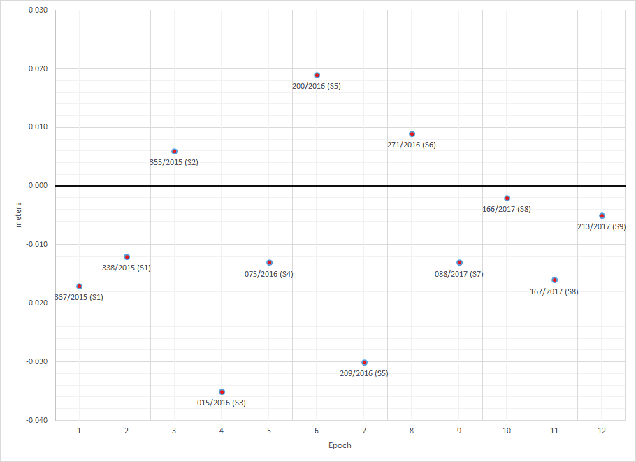
At this particular dam here is a history over the last two years of OPUS solutions for the PPC. Note that we center the antenna very carefully, to better than 1 mm using an optical plummet. Coordinate 0,0 on the chart is the published NAD83 (2011) position. The PPC is not the most unobstructed station around, it has deciduous trees about 20 meters to the east. Typical observation times are 6 hours. Published network accuracies are 0.65 cm H and 1.39 cm V.
Vertical, as expected, about 1.5X worse, although most are within ?ñ0.02 m of published.
The reason for doing this survey 6 times a year is that they are working a new underground longwall coal mine nearby. So the above differences in position could be due to mining (doubtful) or simply the accuracy attainable with OPUS using ~6 hour sessions.
At the top establish a temp bracket with hole cut to hole a ball prism, establish ENZ on the prism, point the prism down, establish tripod centered at bottom of gallery with plummet, swap TS to tribrach and measure EDM to prism.
Random ball prism found on internet; http://www.capitalsurveyingsupplies.com/50-mm-diameter-prism-ball/
J.H. Thanks for the post and the explanation. Trig leveling is out. One thing is you are lucky that you have a short
vertical distance (~12 meters). Also that level line through the woods does not look like it is fun;
if leveling can ever be fun.
JOHN NOLTON
JOHN NOLTON, post: 441686, member: 225 wrote: J.H. Thanks for the post and the explanation. Trig leveling is out. One thing is you are lucky that you have a short
vertical distance (~12 meters). Also that level line through the woods does not look like it is fun;
if leveling can ever be fun.JOHN NOLTON
The worst part about that level line is we ran it twice, once with a standard rod, which didn't close, and then with an invar rod, which did. It was no fun, cold, raining, miserable. At least it was in winter with no leaves on the trees.
