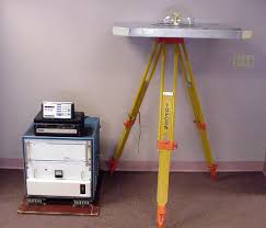
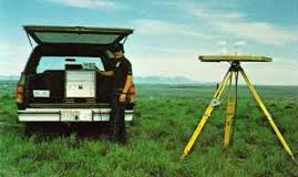
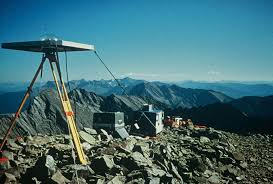
My only encounter with such a thing was purely accidental. I was driving between two of our farms one day and encountered a fellow operating one of these. That was probably about 1986-1990. The tripod was setting over a USGS monument in a railroad right-of-way within 40 feet of the center of the county road I was on. His Suburban was completely full of gear and running with the air-conditioner on. We had a nice chat. He was involved with a project via the FAA concerning a small airport roughly 30 miles away in a straight line. The A/C was on to keep the electronics cool. The vehicle's battery and electrical system were beefed up to handle the constant extra loading. I hadn't thought about that much until I attended a educational program featuring Jan Van Sickle two weeks ago. He was describing his early experiences with GPS when a photo similar to one of these appeared on the big screen. It is called a Macrometer.
http://amhistory.si.edu/surveying/object.cfm?recordnumber=997498
http://link.springer.com/article/10.1007/BF02520902
http://link.springer.com/article/10.1007/BF02521057
http://scrippsscholars.ucsd.edu/ybock/content/geodetic-accuracy-macrometer-model-v-1000
Those were lots of fun...3 AM in the dead of winter, pull up to the point, fire up the generator...then sit there for 2 hours. And hope the wind wasn't blowing, the ground plane made a nice sail.
I read about those in the early GPS days when I was in autodidactic mode in book/articles by Van Sickle and there was another book available from a Canadian group.
I thought it was only government and oil field operations that were users. There were private survey companies such as John Chance in Lafayette LA that were involved in pushing GPS usage in the Gulf of Mexico. I think Chance had their own satellites or own way of doing vlbi in the early days,
I agree with John Hamilton that the early days were fun when you had only a few hours to lock on a 3 or 4 birds.
It could be early early in the morning in the dark or the middle of the night.
You did the session and then reconned the next days observation points.
Getting and setting up
On a station in a coastal marsh in the dark was a challenge since there wasn't any GPS nav to get you there.
: )
My first job out of college in 1986 was with Geo/Hydro, which was one of the first (or the first) GPS company, they started out using Macrometer V1000's (pictured in the first post) around 1984. Each day before the sessions we had to bring all of the units together and sync the clocks using either GOES time receiver or a Trimble 4000A. Then the 4000S came out, and we started using those for "lower order" surveys. The V1000 required a $3000/month subscription to get an ephemeris for processing, whereas the Trimble did not (but there was no software at first).
I remember processing the V1000 data, on a special computer, took a day or so to process a few baselines, manually fixing cycle slips.
At the DOT we helped David Doyle and the NGS boys complete the HARN network in '92 and '93. By then we were all using the Ashtech MXII and Trimble 4000SST. We still fought some tough mission planning and limited constellation geometry waiting for a minimum of six SVs above a 10 degree mask. Those were the days...(NOT)..
I always thought I wanted to run one of those and they were around after I started my career in 1979, but I think largely gone sometime around 1985'ish. I did come upon one collecting once with the operator reading a good novel, thought that would be the life...
John probably knows, but weren't these things around $250K EACH?
SHG
John Hamilton, post: 389093, member: 640 wrote: Those were lots of fun...3 AM in the dead of winter, pull up to the point, fire up the generator...then sit there for 2 hours. And hope the wind wasn't blowing, the ground plane made a nice sail.
I thought you guys in the US got the user friendly constellation times! That was what our lecturer at university (in Australia) told us when we had to get up around 3am to go see one of the first Trimble units, which took up the entire back cargo area in a Landcruiser.
All that sleeping time wasted to look at a big silver box with flashing lights! This was back in 85 or 86. A few years after that I was viewing magnavox MX1502 units as the height of portability when I was working on seismic crews. Good times.
Sent from my SM-G935F using Tapatalk
In The Sandpit, post: 389124, member: 99 wrote: I thought you guys in the US got the user friendly constellation times! That was what our lecturer at university (in Australia) told us when we had to get up around 3am to go see one of the first Trimble units, which took up the entire back cargo area in a Landcruiser.
All that sleeping time wasted to look at a big silver box with flashing lights! This was back in 85 or 86. A few years after that I was viewing magnavox MX1502 units as the height of portability when I was working on seismic crews. Good times.
Sent from my SM-G935F using Tapatalk
They were just as messed up here as anywhere else. In the central US we use to experience what we called "satellite siesta". It was an anomaly that consistently occurred between 1 and 4 pm where there was almost nothing in the sky...except for the one SV that the NANUs said was being serviced..
We still get a PDOP spike around noon to 1pm.
Yeah I saw a Macrometer demo when I was with the Geodetic Survey Squadron in Cheyenne- We had asto pos teams using T4s and we used MX1502 and JMR1 for Doppler work- The first operational GPS gear I sued was a TI 4100 man that thing was big and bulky.
TI400 was portable compared to the macrometer. The timing in the east coast was middle of the night in winter, middle of the day in summer. Supposedly optimized over Yuma Arizona for testing. Had a guy working for me back then who got arrested for DUI driving between points in the middle of the night. Another weird thing back then was NOBODY had ever heard of GPS, so explaining what you were doing to the police at 4 AM was always interesting.
An alarm clock, blanket, and pillow were standard items in the truck in the winter.
Yes, they were $250K. Then a new box came out, I forget the name (maybe istac?), they were *only* $125K. So we bought a bunch. And they did not work well at all, pretty much good for about 25 cm. That set the company on a path to bankruptcy. Trimble 4000S (either 4 or 5 channel, I don't remember) were a bargain at $50K.
We used the Macrometers for the first network GPS survey ever performed which was Summit Co., Ohio in 1983. The process was as John Hamilton described above. Based on that work and a subsequent review and analysis NGS abandoned the use of triangulation in 1984. As they say, the rest is history. To my knowledge the last complete Macrometer is the one pictured above which is in the NGS office in Silver Spring, MD. NGS has at least one other antenna but the plexiglas antenna cover has been broken. Those were replaced with TI4100's and a few Wild WM101s.
Were those Macrometers single or dual frequency? I remember the WM101 (WM was Wild - Magnavox) and WM102; the 102 was dual frequency.
paden cash, post: 389102, member: 20 wrote: At the DOT we helped David Doyle and the NGS boys complete the HARN network in '92 and '93. By then we were all using the Ashtech MXII and Trimble 4000SST. We still fought some tough mission planning and limited constellation geometry waiting for a minimum of six SVs above a 10 degree mask. Those were the days...(NOT)..
I remember with the 4000SST's we always aimed them the same direction under the theory that we didn't know exactly where the phase center was, and if they were always the same directions as the others running @ the same time, any offset in the phase center would be the same so that their relative positions would cancel out that part of the error.
Tom Adams, post: 389182, member: 7285 wrote: I remember with the 4000SST's we always aimed them the same direction under the theory that we didn't know exactly where the phase center was, and if they were always the same directions as the others running @ the same time, any offset in the phase center would be the same so that their relative positions would cancel out that part of the error.
We had a lot of "superstitious" procedures we adopted. Some were based in fact, some not. One "Location Engineer" (the head PLS at one of 13 field survey offices) had labeled the antenna and cables to correspond with each receiver. He was convinced that once a receiver had been connected to an antenna, it would not work correctly with any other antenna. My specific voodoo was to get it set up and turned on and then nap in the truck. That way if anything went wrong, it could not have been my fault as I was 15 meters away from it asleep...
Those were the days where either Trimble or Ashtech (whoever was low bidder) would send their rep for a "training" day. Four hours of gobble-d-gook about multipath and PDOP and then after lunch they'd show us how to set them up and turn them on....then maybe get a half hour at the end of the day on the processing software. We came to realize the processing software was written by folks halfway around the world that didn't speak 'Engelska' very well and the trainers knew just as little as we did..
I remember starting the processing (with an IBM 486) on files when I left the office at 6PM. If I was lucky it might be finished when I returned the next morning at 6AM. I do not miss those days at all.
paden cash, post: 389208, member: 20 wrote: ....I remember starting the processing (with an IBM 486) on files when I left the office at 6PM. If I was lucky it might be finished when I returned the next morning at 6AM. I do not miss those days at all.
386, 486, and then finally the 586 which was called the pentium. yes...and hit the process button before you go home. Find your errors, if there were any, and reprocess if necessary the end of the next day. And the pentium math module (double precision) that had a bug they had to fix. Gotten a bit higher-power computers since then.
I believe the first GPS that I saw was sitting on a CalTrans second order traverse point just North of my office on U.S. Highway 101. There was a tripod with a antenna more like today's antennas. There was a tent nearby with a soldier from Great Britain on loan to the Defense Mapping Agency and a large box with Lexie(sic) lights continually changing the position of the antenna. The large box was made by Magnavox. There were more of these receivers scattered about my county on State second order points and USC&GS points. It appeared that they were ground truthing their derived locations. The team was supported by helicopters and military vehicles. The Englishman was at that same site for several weeks.
Yep. Dr. Richard Collins and the macrometer. No code received. Interferometic measurement of the doppler shift of the GPS signal. The TI-4100s came out, $175k a box, single frequency. Then Charlie Trimble and Trimble 4000S when Javad was working for him. Those were the days, we knew the madness of insatiable quest for precise positioning was the future for the surveyor and public. Seems both like yesterday and a long time ago. Thanks for trip down memory lane, I feel older than dirt now. LOL
Sent from my SM-G920V using Tapatalk
If it was 1983 then it was probably the first. I had thought that the City of Pittsburgh was the first city wide GPS survey, but it was 1984. I remember the newspaper covered a news conference in Point Park about the "new space technology", but the problem was they called it satellite surveillance rather than satellite surveying.
I later worked for the company that did the 1984 Pittsburgh survey, I tried to get the 1984 data, but it had been backed up on VHS tapes (un-retrievable) using a VCR that a guy that worked there rigged up somehow. .
Tom Adams, post: 389182, member: 7285 wrote: I remember with the 4000SST's we always aimed them the same direction under the theory that we didn't know exactly where the phase center was, and if they were always the same directions as the others running @ the same time, any offset in the phase center would be the same so that their relative positions would cancel out that part of the error.
NGS still calibrates antennas with an antenna orientation in mind or I still point the "north" reference mark on my antennas north within a few degrees using a compass for ALL of my static work, not so much obviously for continuous kinematic such as road profile, etc. because it is pretty much impossible and for that work probably doesn't matter.
SHG


