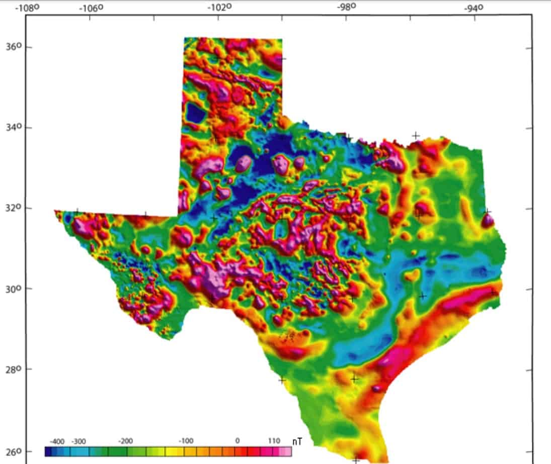
Looks to me like one should not have too much trouble finding magnetic anomalies in Texas.
http://pubs.usgs.gov/ds/2006/232/
Loyal
Loyal, post: 382265, member: 228 wrote: Looks to me like one should not have too much trouble finding magnetic anomalies in Texas.
The land surveyor is more interested in declination anomalies that total field anomalies, though. Do we think that aerial survey methods can detect declination anomalies with a standard error of under 20 minutes?
Kent McMillan, post: 382268, member: 3 wrote: The land surveyor is more interested in declination anomalies that total field anomalies, though. Do we think that aerial survey methods can detect declination anomalies with a standard error of under 20 minutes?
Don't know.
BUT, my experience with Magnetic Surveys (Air-Mag, Ground Mag w/ a proton magnetometer), and the "running" of geophysical grid lines (with magnetic variance observations with a compass), indicate a correlation between total field strength anomalies and "LOCAL variation of the needle." 5-10 degrees in VERY short distances are not unheard of, and local variances UP to 5 degrees is not all that uncommon, even in areas one might not expect.
Mileage will of course vary, but I have SEEN the results of hundreds of careful observations across a good chunk of the Western US.
Loyal
Loyal, post: 382272, member: 228 wrote: BUT, my experience with Magnetic Surveys (Air-Mag, Ground Mag w/ a proton magnetometer), and the "running" of geophysical grid lines (with magnetic variance observations with a compass), indicate a correlation between total field strength anomalies and "LOCAL variation of the needle." 5-10 degrees in VERY short distances are not unheard of, and local variances UP to 5 degrees is not all that uncommon, even in areas one might not expect.
I'm going to go out on a limb and say that the only place in Texas where declination anomalies of even 2å¡ would be commonly encountered in natural settings free of artificial objects would be near igneous intrusions like old volcanic plugs. Everywhere, else mostly not.
Kent McMillan, post: 382281, member: 3 wrote: I'm going to go out on a limb and say that the only place in Texas where declination anomalies of even 2å¡ would be commonly encountered in natural settings free of artificial objects would be near igneous intrusions like old volcanic plugs. Everywhere, else mostly not.
I will certainly defer to your experience in Texas.
My [very] limited knowledge of geology does extend into that part of the country. Just bear in mind that magnetic anomalies are not limited to (obvious) igneous intrusions.
Loyal
Loyal, post: 382287, member: 228 wrote: My [very] limited knowledge of geology does extend into that part of the country. Just bear in mind that magnetic anomalies are not limited to (obvious) igneous intrusions.
When we are mainly concerned about declination anomalies, there are two important clues to the presence or absence of them. The obvious first clue are the actual declination observations that were made in all of the Texas counties. The second clue lies in the directions of lines surveyed with compasses. Where lines run for miles pretty nearly as straight as can be run with a compass, the for all practical purposes declination anomalies aren't a factor.
Loyal's post with the magnetic anomalies comes as close as one could ever hope to creating the appearance of a very large lake in the Texas Panhandle. This must be a mirage effect instead of a magnetic effect.
Holy Cow, post: 382317, member: 50 wrote: Loyal's post with the magnetic anomalies comes as close as one could ever hope to creating the appearance of a very large lake in the Texas Panhandle. This must be a mirage effect instead of a magnetic effect.
Those blue areas are actually areas where there are a large population of Republicans. It's hard to get them to vote however, due to the fact their horns won't fit through the doorway...
post disappearing in three...two...one
One other interesting detail about those latitudes and longitudes is that they were probably taken with a sextant. The apparent precision of a position such as that of the station on the Pecos River given as 31å¡52'31" N; 103å¡48'54" W were most likely just the result of averaging the results from a series of observations, not using an extremely precise instrument.
I can't help but wonder if that Pecos River was Pope's Wells encampment.
Andy Nold, post: 382660, member: 7 wrote: I can't help but wonder if that Pecos River was Pope's Wells encampment.
Kuechler and his surveying party did cross the Pecos at Pope's Crossing and so must have followed the Butterfield Overland Trail West from Fort Chadbourne.
The early military exporations, including that of Brevet Capt. Pope, expressed observed longitudes in relation to that of the Naval Observatory in Washington, which was apparently assigned an offiiclal longitude of 77å¡02'48.0" W from Greenwich during the period from 1855 through 1869.
Longitudes were also reported by the early explorers in terms of time, so
31å¡52'31" N
103å¡48'54" W
would have been reported with a longitude of
6hrs 55min 16sec W


