Reading RPLS is free for the whole profession. Members post, reply, and get the members-only rooms.


Notifications
Clear all
Software, CAD & Mapping
7
Posts
4
Users
0
Reactions
940
Views

Topic starter
Translate
▼
English
Spanish
French
German
Italian
Portuguese
Russian
Chinese
Japanese
Korean
Arabic
Hindi
Dutch
Polish
Turkish
Vietnamese
Thai
Swedish
Danish
Finnish
Norwegian
Czech
Hungarian
Romanian
Greek
Hebrew
Indonesian
Malay
Ukrainian
Bulgarian
Croatian
Slovak
Slovenian
Serbian
Lithuanian
Latvian
Estonian
I do not have, nor have I ever seen, a Carlson data collector. I will probably be working with a company who uses Carlson data collector (not sure what software) with Leica receivers. I want to get the raw GPS vector components (DX, DY, DZ) and a correlation matrix or something similar to do adjustments for multiple occupations of points.
So I asked a friend who is knowledgeable about Carlson office software, and he sent me a link to the manual for SurvCE, and it had the following:
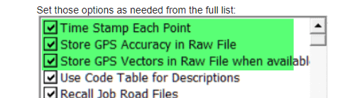
So, I wonder what that data looks like in the data collector file? Is it ascii? Can it be imported to Star*Net? Are there other possibilities than SurvCE that they might have and that might be different? I asked my client to ask them exactly what hardware/software they are using, but I have not yet heard back.
Posted : October 24, 2017 2:50 pm

Translate
▼
English
Spanish
French
German
Italian
Portuguese
Russian
Chinese
Japanese
Korean
Arabic
Hindi
Dutch
Polish
Turkish
Vietnamese
Thai
Swedish
Danish
Finnish
Norwegian
Czech
Hungarian
Romanian
Greek
Hebrew
Indonesian
Malay
Ukrainian
Bulgarian
Croatian
Slovak
Slovenian
Serbian
Lithuanian
Latvian
Estonian
John,
It (Carlson Surve-CE) appears to be receiver dependent in that regard (and they are ASCII files).
When attached to a X90+
 GPS,PN0819105,LA40.363540912942,LN-111.320234072864,EL2797.945311,--2 IN AC ALLIANCE 4-5398
--GS,PN0819105,N 173298.6553,E 54278.0726,EL9223.3445,--2 IN AC ALLIANCE 4-5398
G0,2016/08/19 19:58:55,(Average) - Base ID read at rover: 0015
G1,BP15,PN0819105,DX-1101.40445,DY709.97171,DZ446.01219
G2,VX0.00001617,VY0.00005872,VZ0.00003984
G3,XY0.00001378,XZ-0.00000536,YZ-0.00002576
--GT,PN0819105,SW1910,ST503733000,EW1910,ET503952000
--Valid Readings: 180 of 180
--Fixed Readings: 180 of 180
--Nor Min: 173298.6214  Max: 173298.6897
--Eas Min: 54278.0469  Max: 54278.0885
--Elv Min: 9223.2881  Max: 9223.4031
--Nor Avg: 173298.6553  SD: 0.0123
--Eas Avg: 54278.0726  SD: 0.0065
--Elv Avg: 9223.3445  SD: 0.0259
--NRMS Avg: 0.0160 SD: 0.0003 Min: 0.0155 Max: 0.0173
--ERMS Avg: 0.0116 SD: 0.0002 Min: 0.0113 Max: 0.0125
--HSIG Avg: 0.0198 SD: 0.0003 Min: 0.0193 Max: 0.0214
--VSIG Avg: 0.0291 SD: 0.0004 Min: 0.0286 Max: 0.0313
--HDOP Avg: 0.7067  Min: 0.7060 Max: 0.7075
--VDOP Avg: 1.2057 Min: 1.2006 Max: 1.2100
--PDOP Avg: 1.3975 Min: 1.3928 Max: 1.4017
--Number of Satellites Avg: 17 Min: 17 Max: 17
--DT08-19-2016
--TM13:59:18
It does.
When attached to an i80
 GPS,PN0820100,LA40.361653740882,LN-111.332263821040,EL3001.825682,--POSS STONE MOUND
--GS,PN0820100,N 507749.8021,E 13623.1976,EL9892.0957,--POSS STONE MOUND
--GT,PN0820100,SW1963,ST59251000,EW1963,ET59455000
--Valid Readings: 193 of 193
--Fixed Readings: 193 of 193
--Nor Min: 507749.7835  Max: 507749.8238
--Eas Min: 13623.1786  Max: 13623.2185
--Elv Min: 9892.0516  Max: 9892.1420
--Nor Avg: 507749.8021  SD: 0.0060
--Eas Avg: 13623.1976  SD: 0.0087
--Elv Avg: 9892.0957  SD: 0.0151
--NRMS Avg: 0.0256 SD: 0.0015 Min: 0.0233 Max: 0.0286
--ERMS Avg: 0.0253 SD: 0.0016 Min: 0.0229 Max: 0.0285
--HSDV Avg: 0.0360 SD: 0.0022 Min: 0.0327 Max: 0.0404
--VSDV Avg: 0.0712 SD: 0.0036 Min: 0.0659 Max: 0.0784
--HDOP Avg: 0.6881  Min: 0.6844 Max: 0.6918
--VDOP Avg: 1.1737 Min: 1.1728 Max: 1.1742
--PDOP Avg: 1.3605 Min: 1.3579 Max: 1.3629
--Number of Satellites Avg: 17 Min: 17 Max: 17
--DT01-15-2015
--TM08:26:08
It does not.
"They" are supposedly working on that!
Loyal
Posted : October 24, 2017 3:44 pm
Topic starter
Translate
▼
English
Spanish
French
German
Italian
Portuguese
Russian
Chinese
Japanese
Korean
Arabic
Hindi
Dutch
Polish
Turkish
Vietnamese
Thai
Swedish
Danish
Finnish
Norwegian
Czech
Hungarian
Romanian
Greek
Hebrew
Indonesian
Malay
Ukrainian
Bulgarian
Croatian
Slovak
Slovenian
Serbian
Lithuanian
Latvian
Estonian
Thanks, Loyal. I will ask them for a sample of their data. I am used to working with trimble receivers/trimble data collector/survey controller or access.
Posted : October 24, 2017 4:20 pm

Translate
▼
English
Spanish
French
German
Italian
Portuguese
Russian
Chinese
Japanese
Korean
Arabic
Hindi
Dutch
Polish
Turkish
Vietnamese
Thai
Swedish
Danish
Finnish
Norwegian
Czech
Hungarian
Romanian
Greek
Hebrew
Indonesian
Malay
Ukrainian
Bulgarian
Croatian
Slovak
Slovenian
Serbian
Lithuanian
Latvian
Estonian
I was under the impression Carlson software would not work with Leica receivers. That's why I got the Geomax brand. Then again I run network GNSS, so maybe that's where the conflict appears.
Posted : October 24, 2017 4:34 pm
Topic starter
Translate
▼
English
Spanish
French
German
Italian
Portuguese
Russian
Chinese
Japanese
Korean
Arabic
Hindi
Dutch
Polish
Turkish
Vietnamese
Thai
Swedish
Danish
Finnish
Norwegian
Czech
Hungarian
Romanian
Greek
Hebrew
Indonesian
Malay
Ukrainian
Bulgarian
Croatian
Slovak
Slovenian
Serbian
Lithuanian
Latvian
Estonian
I have not directly spoken with them, this is what I was told by my client, I have asked for an exact list of equipment and a sample file
Posted : October 24, 2017 4:40 pm

Translate
▼
English
Spanish
French
German
Italian
Portuguese
Russian
Chinese
Japanese
Korean
Arabic
Hindi
Dutch
Polish
Turkish
Vietnamese
Thai
Swedish
Danish
Finnish
Norwegian
Czech
Hungarian
Romanian
Greek
Hebrew
Indonesian
Malay
Ukrainian
Bulgarian
Croatian
Slovak
Slovenian
Serbian
Lithuanian
Latvian
Estonian
I believe the G lines (the vector components) are identical for all receivers that make them.
The PDF in this folder [ https://www.x9gps.com/Tools/Utilities/RW52GPS/index.html&apos ;">RW52GPS ] has some examples and some notes.
Here is the [ http://web.carlsonsw.com/files/knowledgebase/kbase_attach/223/Raw%20File%20Records_3.0.pdf&apos ;">vector definition ]
Posted : October 24, 2017 4:44 pm
Topic starter
Translate
▼
English
Spanish
French
German
Italian
Portuguese
Russian
Chinese
Japanese
Korean
Arabic
Hindi
Dutch
Polish
Turkish
Vietnamese
Thai
Swedish
Danish
Finnish
Norwegian
Czech
Hungarian
Romanian
Greek
Hebrew
Indonesian
Malay
Ukrainian
Bulgarian
Croatian
Slovak
Slovenian
Serbian
Lithuanian
Latvian
Estonian
Great info, thanks Mark.
Posted : October 24, 2017 5:03 pm