Reading RPLS is free for the whole profession. Members post, reply, and get the members-only rooms.


Notifications
Clear all

Topic starter
Translate
▼
English
Spanish
French
German
Italian
Portuguese
Russian
Chinese
Japanese
Korean
Arabic
Hindi
Dutch
Polish
Turkish
Vietnamese
Thai
Swedish
Danish
Finnish
Norwegian
Czech
Hungarian
Romanian
Greek
Hebrew
Indonesian
Malay
Ukrainian
Bulgarian
Croatian
Slovak
Slovenian
Serbian
Lithuanian
Latvian
Estonian
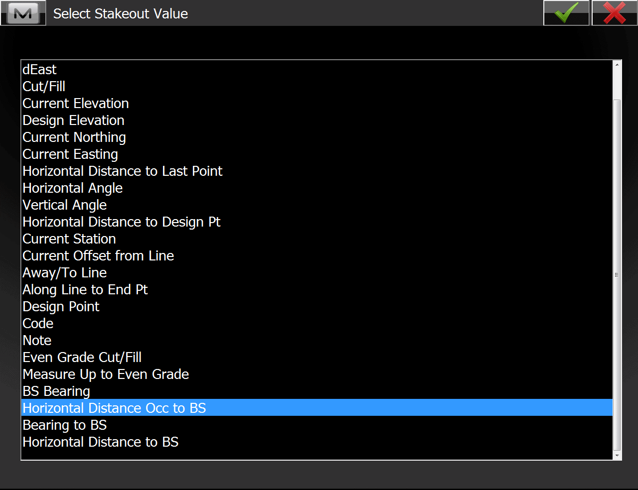
In the Magnet stake to line program, it seems they have 3 data fields that give you the exact same information.
In good old Survey Pro the to & from would be the horizontal distance from the instrument to get on the line; which was quite helpful when in the woods and having limited line of sight.
With Magnet it replicates the distance perpendicular to the line, oriented to the end point, which near useless considering you already have a side offset distance to station.
Anyone know how to get an actual "to & from" distance; the green line on the image below?
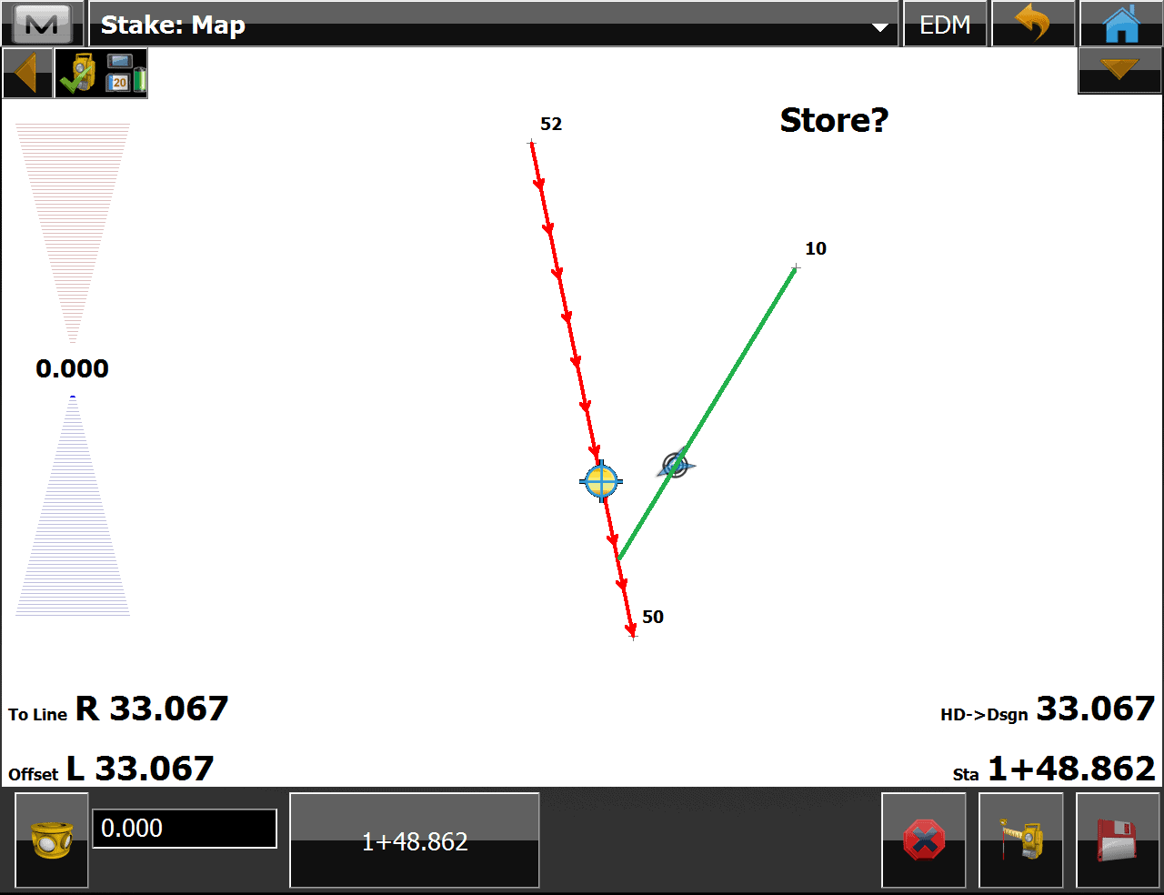
Here are the data field options:
Posted : August 10, 2017 8:46 am

Translate
▼
English
Spanish
French
German
Italian
Portuguese
Russian
Chinese
Japanese
Korean
Arabic
Hindi
Dutch
Polish
Turkish
Vietnamese
Thai
Swedish
Danish
Finnish
Norwegian
Czech
Hungarian
Romanian
Greek
Hebrew
Indonesian
Malay
Ukrainian
Bulgarian
Croatian
Slovak
Slovenian
Serbian
Lithuanian
Latvian
Estonian
Maybe away to line
Posted : August 10, 2017 9:10 am
Topic starter
Translate
▼
English
Spanish
French
German
Italian
Portuguese
Russian
Chinese
Japanese
Korean
Arabic
Hindi
Dutch
Polish
Turkish
Vietnamese
Thai
Swedish
Danish
Finnish
Norwegian
Czech
Hungarian
Romanian
Greek
Hebrew
Indonesian
Malay
Ukrainian
Bulgarian
Croatian
Slovak
Slovenian
Serbian
Lithuanian
Latvian
Estonian
mvanhank222, post: 441168, member: 8673 wrote: Maybe away to line
That's the top field in the lower left, which is perp to stationing
Posted : August 10, 2017 10:13 am

Translate
▼
English
Spanish
French
German
Italian
Portuguese
Russian
Chinese
Japanese
Korean
Arabic
Hindi
Dutch
Polish
Turkish
Vietnamese
Thai
Swedish
Danish
Finnish
Norwegian
Czech
Hungarian
Romanian
Greek
Hebrew
Indonesian
Malay
Ukrainian
Bulgarian
Croatian
Slovak
Slovenian
Serbian
Lithuanian
Latvian
Estonian
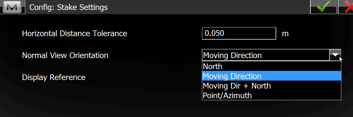
????
Posted : August 10, 2017 12:23 pm
Topic starter
Translate
▼
English
Spanish
French
German
Italian
Portuguese
Russian
Chinese
Japanese
Korean
Arabic
Hindi
Dutch
Polish
Turkish
Vietnamese
Thai
Swedish
Danish
Finnish
Norwegian
Czech
Hungarian
Romanian
Greek
Hebrew
Indonesian
Malay
Ukrainian
Bulgarian
Croatian
Slovak
Slovenian
Serbian
Lithuanian
Latvian
Estonian
Thanks but wasn't it, though that does change the view on the real time stake out screen, which I've been trying to fiddle with.
Posted : August 10, 2017 1:22 pm

Translate
▼
English
Spanish
French
German
Italian
Portuguese
Russian
Chinese
Japanese
Korean
Arabic
Hindi
Dutch
Polish
Turkish
Vietnamese
Thai
Swedish
Danish
Finnish
Norwegian
Czech
Hungarian
Romanian
Greek
Hebrew
Indonesian
Malay
Ukrainian
Bulgarian
Croatian
Slovak
Slovenian
Serbian
Lithuanian
Latvian
Estonian
I know what you're looking for, I've been in the field all week driving home now after a 10-hour day. I believe the command is called PTL which means point to line. I will have to create a screenshot to show you how to turn this on. still find it funny no one else can answer these questions for you. I'm using text-to-talk, while driving. Appears to be working quite well.
Posted : August 10, 2017 3:08 pm
Translate
▼
English
Spanish
French
German
Italian
Portuguese
Russian
Chinese
Japanese
Korean
Arabic
Hindi
Dutch
Polish
Turkish
Vietnamese
Thai
Swedish
Danish
Finnish
Norwegian
Czech
Hungarian
Romanian
Greek
Hebrew
Indonesian
Malay
Ukrainian
Bulgarian
Croatian
Slovak
Slovenian
Serbian
Lithuanian
Latvian
Estonian
OK, finally a chance to get to my PC.
It is not as simple as you would or did with TDS, but can be done.
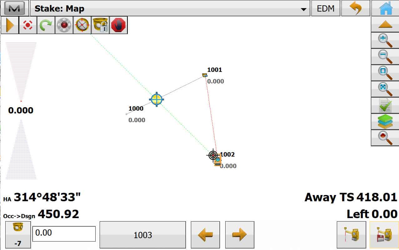
1st you need set your backsight to Azimuth, not Zero.
Then use command Stake> Offsets >Intersection
Line 1
"From Point" 1000
"Az to Point" 1001
Line 2
"From Point" your Instrument Occupied Point 1002
"Azimuth" of your current Inst Horiz Angle 314?ø48'33"
StakeOut
Posted : August 11, 2017 1:22 pm
Topic starter
Translate
▼
English
Spanish
French
German
Italian
Portuguese
Russian
Chinese
Japanese
Korean
Arabic
Hindi
Dutch
Polish
Turkish
Vietnamese
Thai
Swedish
Danish
Finnish
Norwegian
Czech
Hungarian
Romanian
Greek
Hebrew
Indonesian
Malay
Ukrainian
Bulgarian
Croatian
Slovak
Slovenian
Serbian
Lithuanian
Latvian
Estonian
Thanks I'll check that out Monday. Staking out property lines in the woods next week for pre-approval site walk, so that will be handy if it works.
Posted : August 11, 2017 3:20 pm