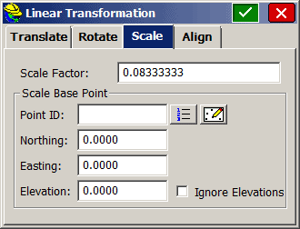
I received a plan from the Landscape Architect and the coordinates were in decimal inches. So, I figured I'd input the coordinates in the DC and then use the "Transformation" menu to scale the coordinates by 0.08333. And after trying several times, we had no luck. It simply added the point number offset, as directed, and created exactly the same coordinates.
Is there some limit to the scale factor?
Why wouldn't they include the ability to scale from inches to feet, or even feet to meters?
Sure would have been a handy thing to have.
Scott Zelenak, post: 330143, member: 327 wrote: I received a plan from the Landscape Architect and the coordinates were in decimal inches. So, I figured I'd input the coordinates in the DC and then use the "Transformation" menu to scale the coordinates by 0.08333. And after trying several times, we had no luck. It simply added the point number offset, as directed, and created exactly the same coordinates.
Is there some limit to the scale factor?
Why wouldn't they include the ability to scale from inches to feet, or even feet to meters?
Sure would have been a handy thing to have.
There isn't a "limit" to my knowledge... I'm presuming your transformation factor(s) resembled the following?
Yeah, that's it.
When we run the routine it doesn't change the coordinates though.
That's what your laptop is for.
The few times I have transformed on the DC it has led to bad results so I avoid it. I don't think the software companies rigorously test their routines. One of the versions of SurvCE would mess up the elevations but at least you could process later. The current version of access deletes all of your observations before the transformation which is really handy!
Scott Zelenak, post: 330355, member: 327 wrote: Yeah, that's it.
When we run the routine it doesn't change the coordinates though.
Which version of SurvCE do you have on the collector? Would it be possible for you to send me your decimal inches file and/or CRD file so I can attempt to replicate the behavior? If so, lnelsonATcarlsonswDOTcom.
" I don't think the software companies rigorously test their routines."
NOT true about Carlson at all.
With the "Brains" they have in Maysville and Boston, their stuff gets looked at real close. Add to that numerous Beta Testers across the country and most things get caught. 100% never will happen because of the "human factor" of the end users.
There's more to it than most think. I got an insight having lunch with Dave Carlson last User's Conference. Dave inhabits a totally different realm than the averagr bear. Probably a different world.
Ladd Nelson, post: 30400, member: 307 wrote: Which version of SurvCE do you have on the collector? Would it be possible for you to send me your decimal inches file and/or CRD file so I can attempt to replicate the behavior? If so, lnelsonATcarlsonswDOTcom.
We are also having trouble when trying to translate & rotate on our Surveyor 2. Sometimes it works & many times it doesn't move the coordinates at all. Cost two crews about 45 min today! We need to get to the bottom of it. We were not adding any scaling to the equation tho.
cptdent, post: 330402, member: 527 wrote: " I don't think the software companies rigorously test their routines."
NOT true about Carlson at all.
With the "Brains" they have in Maysville and Boston, their stuff gets looked at real close. Add to that numerous Beta Testers across the country and most things get caught. 100% never will happen because of the "human factor" of the end users.
There's more to it than most think. I got an insight having lunch with Dave Carlson last User's Conference. Dave inhabits a totally different realm than the averagr bear. Probably a different world.
As much as I love Carlson and the people over there I do often feel like the users end up doing the bulk of the beta testing. I'm sure it's nearly impossible to test it with every piece of equipment SurvCE supports every time they do an update. I once had to convince Bruce Carlson to go to a nearby park and setup a Leica robot and do some tests to prove SurvCE v2.x was not taking into account the final ATR correction and that you would get a different answer each time you checked the backsite. To his credit he was a very humble gentleman who went along with me and accepted my proof there was a problem. He got the software engineer on the phone right then and there and figured out what the problem was. Great guy. I can see why he has had such great success with the Carlson company.
My policy is to stick to v1.67, 2.61, or Leica SurvCE v2.09 with the Leica 1200 robotic guns. There are probably some gems in the newer versions, but I haven't had a chance to experiment yet.
-Will Haynes


