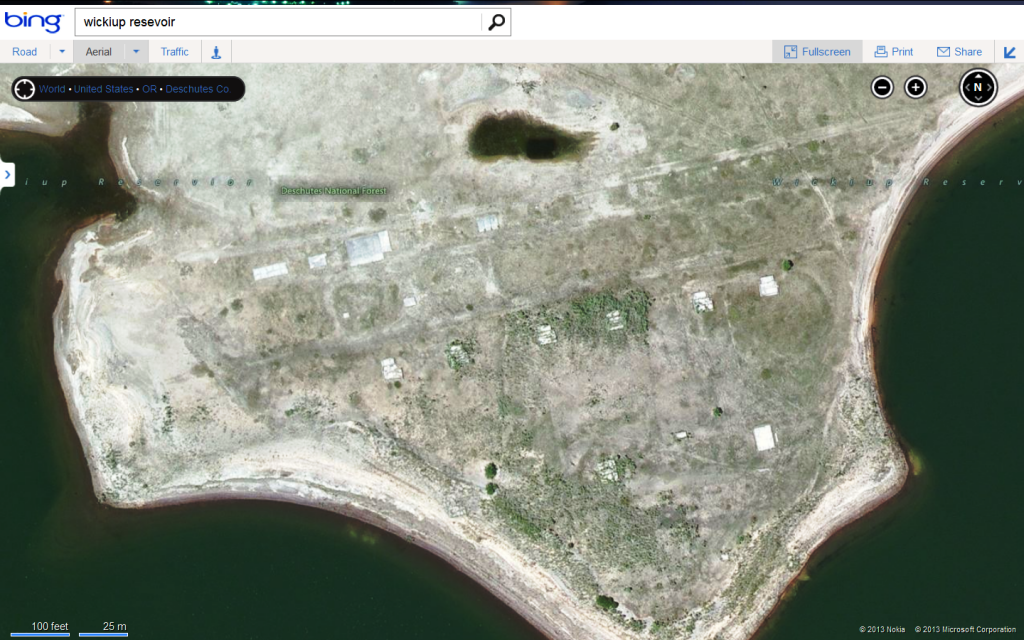
A couple months ago I received an email from an author in Ohio, Gary, who is writing a booklet about a now deceased WWII soldier from Ohio who in his youth had worked at the Civilian Conservation Corps “Camp Wickiup”. Gary made extensive searches of historical records but could not pinpoint the location of the camp, which he knew from various accounts was within the area that had been inundated by Wickiup Reservoir.

Prior to the dam being built, the area was known as “The Wickiups” due to the remains of an old Piute fishing/hunting camp as evidenced in this 1915 map:

The camp was opened in 1938 to house CCC workers logging the reservoir site and building the dam.

Gary sent some photos he’d found of the camp, but there were no telling geographic clues to where it was located:


I’d never heard of the camp so I had him contact my friends John and Jean, a retired couple who are hands down the most knowledgeable history sleuths in the area.
John and Jean knew of other CCC camps in the area, but not Wickiup. They searched all the likely local and state records to no avail concerning the exact location. They know just about everyone in town over the age of 80 but none of the thin gray line were of any help. So they drove down to the reservoir and started chatting up campers, fishermen, and USFS folks. A Camp Ground host recalled seeing a map at the South Twin Lakes resort store and sure enough, there was this aerial photo on the wall with the "Old CCC Camp" labeled:

The location was somewhat vague on the old photo (and it turned out, incorrect), but when they got home and google earth’d it, the ruins of the camp jumped out:

Since the reservoir is low now, the dog and I took the kayak out to take a look see at the camp remains.
There’s lots of mud flats right now and a good many birds, including pelicans, cranes, herons, ospreys and eagles.

The stumps show that this was a big oldgrowth Ponderosa Pine forest when it was logged in the 1930s


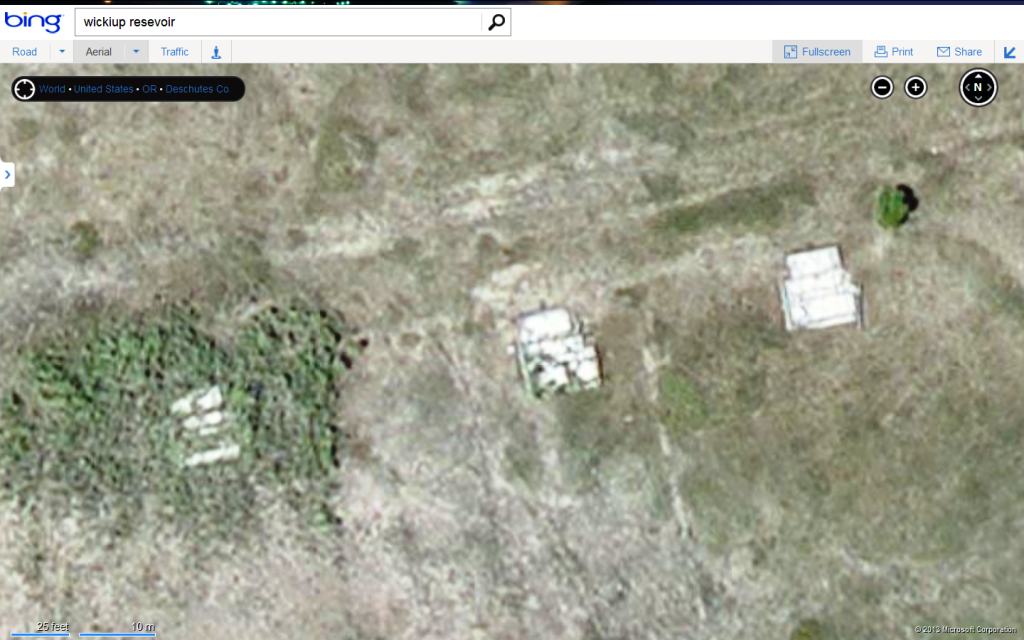
After a paddle of 1.5 miles we got to the camp. At its peak the camp had over 600 workers and from Gary’s photos it appears that the barracks were not built on permanent, substantial foundations. The majority of the remains (6) are the concrete foundations of what appeared to be bathhouses, with 5 toilet fixtures in one room and maybe a community showers in the other:


The north row of concrete slabs in the aerial photo I believe are the “camp shops and garage” shown in a snowy 1939 photo.


The southerly two remains in the aerial were larger 30’X40’ structures without the toilet facilities. The easterly one has what may have been a 3 holer outhouse next to it:

Once WWII began, Camp Wickiup became a “Civilian Public Service” (CPS) camp for Conscientious Objectors. They continued the work on the reservoir site, fought forest fires and built roads.
The CPS camp was closed in 1946 and the camp was razed in 1947.
It would be interesting to find out if the CCC had standard plans for their camp buildings. I’ve seen lots barracks photos, but none of these more substantial buildings.
From the boat ramp by Wickiup Butte:


Great Story! Actually visiting the ruins kind of ties everything together.
Mike, nice find. Sure jumps right out in GE, never had seen that before. I take it that this is submerged when the reservoir is full? I haven't been out there in a few years, probably was out there last to use the HARN about 1.6 miles easterly of the camp on the SE end of the dam.
SHG
> Sure jumps right out in GE, never had seen that before.
You got that right Shelby. When John emailed me the GE coords and I zoomed in I was amazed to see it jump out like that. Wouldn't have had any idea what it was if I'd found it on my own. I haven't been to Wickiup when it is full, but judging by a big shiny fishing lure I found in the middle of the camp, I'd guess it is under water part of the year.
Thanks Perry. My only regret is that John and Jean didn't have time to go out since (1) they unraveled the mystery and (2) they have a fancy metal detector. The place has probably been gone over in the past, but you never know.
Edit: had they gone and had we found, say, a 1934 penny or the button of a coat, we would have only documented it in situ and then immediately notified the appropriate govt. agencies. In triplicate.
Great Story. It looks like you had a dog and a bald eagle kind of giving the tour for part of it...
Halfway through, I was thinking of making some kind of snide remark, like why don't you look closely at the old photos for a lat and long....and then though about "why don't you just search for "Camp Wickiup" on Google Maps". It looks like my second remark came close to the truth.
Thanks for posting this.
Nice work Mike, It really pops out on GE when your looking in the right place. The roads seem to show up pretty good too. Seems logical the same road alignments were probably used back then. The August 2005, and the July 1994 photos on GE really show the roads and site at dry times.
Bing Maps "Camp Wickiup"
wanted to see the resolution difference as Bing maps are usually much better than google. Looks like the contrast on Google Maps is better then Bing in your area.


Once was a CCC camp on the Umatilla River about 30 +/- miles above Pendleton. It was turned into Prisoner of War Camp for German Prisoners. I remember seeing prisoners in it after the war, a big deal for a kid. Those prisoners were used in work gangs on many projects around the area and were well thought of. That camp was razed in the early 50's after sitting vacant for several years.
jud
Jud - Camp Stark (NH)
We had a similar German Prison Camp in northern NH in the town of Stark NH. It was a CCC camp before WW2 and was converted to a prison camp. I've seen a couple documentaries about the place and I remember the prisoners are also well thought of by the locals. The locals and the former POW's have had a few reunions and one of the locals had even visited a former POW in Germany.
Stark remembers former POW Camp

Great post! The research is fun but to actually visit the site is way cool. B-)
Mike,
Looks like this would be a good story for the "Oregon Surveyor".
Joe and Jean
Terrific story! I love stuff like this. Thanks very much for the post.
Cheers,
Henry
> Mike,
> Looks like this would be a good story for the "Oregon Surveyor".
>
> Joe and Jean
Joe, it's funny you mention that because early on I was wondering if they had old plans, maps and the like for these camps that would make for an interesting retracement of the layout. Being the feds, I bet they did but if anything survived it's probably un-indexed in a crate in a warehouse back east. Bench runs were probably done to topo and establish elevations for the impounded area (I scanned the foundations for BM disks to no avail) but if so the notes are likely impossible to unearth.
Tell Jean that next month will be the 160th anniversary of the lost Elliott wagon train passing by her folk's place way out east of town. A couple days later they staggered by my house on the way to salvation at the river...
Amazing post!
Great Post! Thanks for sharing.


