
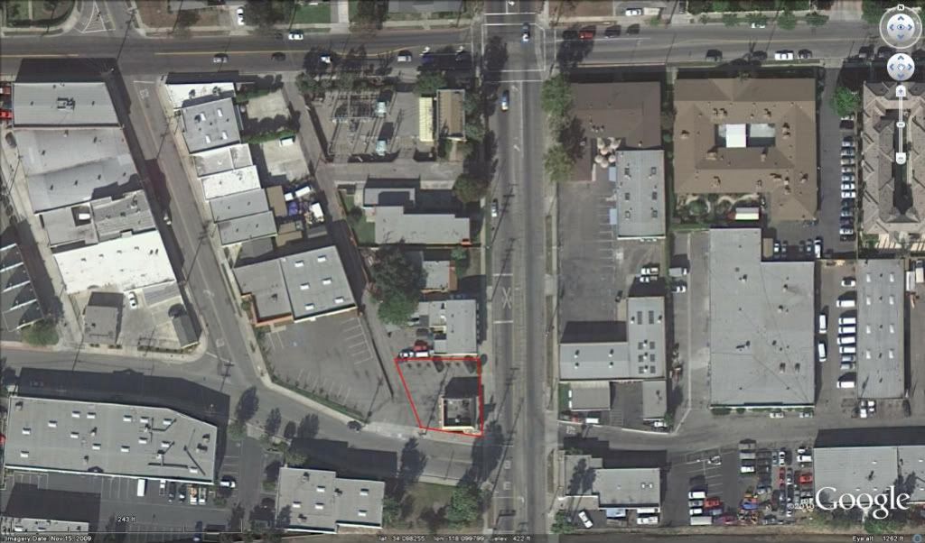
The lot is the red lined corner lot. Last week I sent a proposal out to the gal and she did not want to pay for an RS, so I figured she would get hold of someone that would just drop her lot in using record dimensions and take the money and run..
She was about to sign a contract with someone else but called her architect before she did.. apparently he told her to not sign and call me to do the survey and to pay the RS fee and the other costs I had asked for..she called yesterday.
I think this is one of the most messed up boundaries I have even seen in the San Gabriel Valley. I am really looking forward to doing this one, but it is just pouring right now.
Here's the record map. Try running closures on block 2.
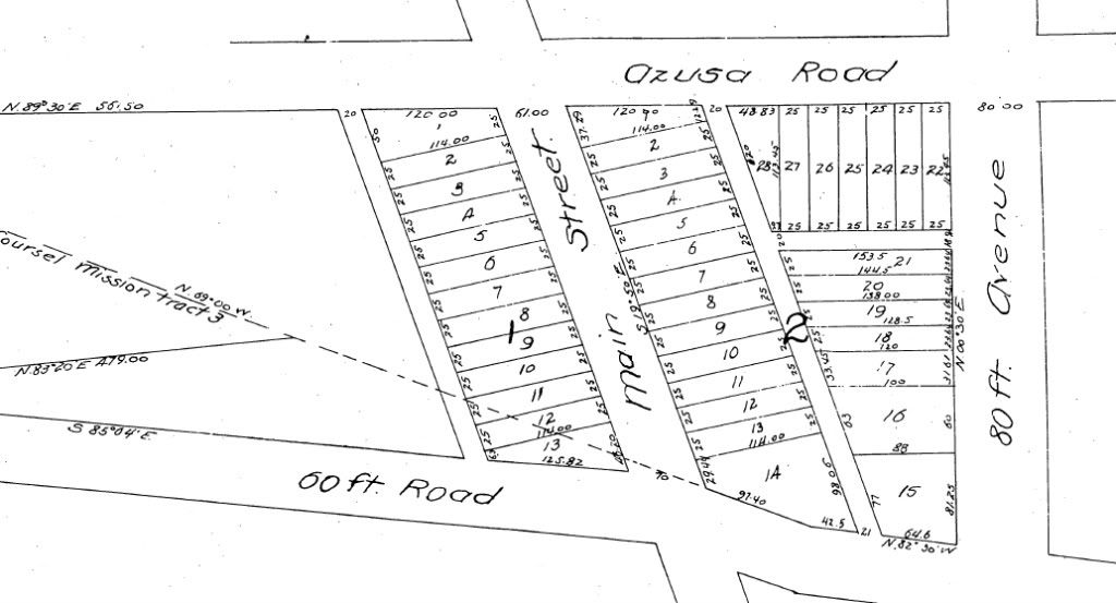
Here is a tax map that will help in clarifying some of the lot dimensions.
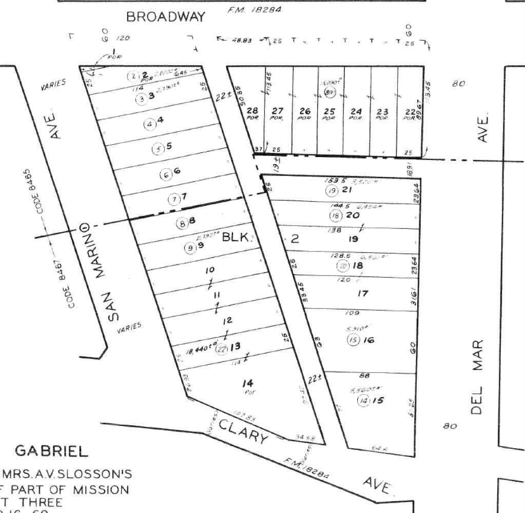
There was a R/W take on the north end for Broadway that did not parallel the lot line. There was also a C/L shift along Del Mar and Clary, which had a new C/L alignment all together.
Monuments exist out here, but for this survey they are low priority. This one will be an occupation based boundary. There are alley approach throats at Broadway, Clary and Del Mar that will play a big part in locating where the alleys join on Broadway and Del Mar, Clary is another matter.
An RS was done in 1921 for lots 7-9. If I get luck I will find the two iron pipes that RS set in the alley. The alley is basically unimproved. All it has is a skimpy AC coating that looks at least 50 years old.
1921 RS
http://survey.dpw.lacounty.gov/landrecords/survey/RS011/RS011-026.pdf
I like these jobs, so many of the LA surveys are so easy it's nice to have one that is a challenge.
Now I need the :rain: to let up
Nice job you got there. Should be a bear. I hope you charged for it.
AS3
Yep, looks like a tough one, but the challenging one can be very rewarding once the boundary is figured out. Regardless of the work volume, these seem to pop up just enough to test/hone your skills. And sometimes, lose hair. 🙂

It looks easy Paul. All the error can go in those plus or minus distances!
Oh yeah the "varies", that's also helpful.

> It looks easy Paul. All the error can go in those plus or minus distances!
> Oh yeah the "varies", that's also helpful.
Yeah, I was thinking the same thing. 🙂
Like what we do here? Donate
Need a new or refreshed website? Five Point Web Solutions
Looking for a web host? Website Hosting & Management
Nice looking job sounds like splitting the alleys are the way to go, along with the mon's from the RS,have fun.
Today's Survey.. the rain stopped...Beautiful Day
Typical LA weather. .pouring until 7 AM then it was like...clearing! The rest of the day was just beautiful with cloudy skies and great temps.
About those +/- distances. Well, those are only shown on the tax map, so they don't count. I'm not sure how the assessor came up with those, but I can't use them. The varies that is shown on the tax map is also unuseable. It is there because a street vacation took place on the west side only of San Marino that was not a parallel vacation, hence the varies.
Here's a picture of the taco stand and part of the parking lot. The gal showed up and handed the retainer and signed contract over, but can you believe it? She did not tell the cooks that we get to eat free ..sheesh!

After we did the architectural on the taco stand we ran line north along Del Mar and placed control where we could shoot all the occupation along the west side of the street for lot sideline bearings. It was not much to locate, just an old building line and a 6" non retaining screen wall.
The alley approach on Del Mar just south of Broadway was the only approach that was useable. That approach worked out well, and using record angle at the split of the approach set up the north alley. There is some minor overlap of a concrete drive surface on the south side but nothing to break a sweat over. There is a large Edison Complex on the north side of the alley and all of thier perimeter walls are clear of the alley R/W. You would think that a company like Edison would have done the right thing and hired a competent surveyor to fix this area with an RS. Probably some Edison project manager looking to make brownie points hired a low baller to survey that site. They lucked out on the walls.
The alley approach on Broadway was within the original lot lines because of the R/W take and the one along Clary was like a 40 foot wide approach, no defining lines on either of them and they could not be used for establishment.
We found one of the 1" iron pipes that the 1921 RS placed, the rest of his monuments were all destroyed. Unfortunately I can only hold his pipe for one lot corner that will tie to another monument we found along San Marino Avenue. If I use any of his dimensions to re establish the SW corner of lot 15 then the lot line would be running about 3 feet inside the Taco Stand.

We ended up locating all the major items within the alley on the west of Del Mar that runs North/South. We also found a lead/nail at the NE corner of lot 15 that an old chainlink fence was built to and is being accepted by both owners of the respective lots. The east/west lot distance has grown by about 18" so far. I am still messing with the north/south alley alignment, so the final length of that line is still an unknown.
San Marino Avenue held a few pleasant surprises. There were 4 tagged leads, LS 2342, one lead only (no nail) and a stupid lil pincushion of 1 inch. Both of the pincushion monuments had the tag pulled out.
Dumb 1" pincushion

OK, here we have a 1" pincushion in a block that has feet mis closure problems, and to top it off, this is the occupation line that is being pin cushioned...

Was a good day all around. I'll finish this up next week and set the lot corners and the alley intersection where the N/S and E/W alley intersect in the block.
It also appears that the city just over built some sidewalk along Clary. Not a big thing really, some places here in Glendale are over built by 5 feet.