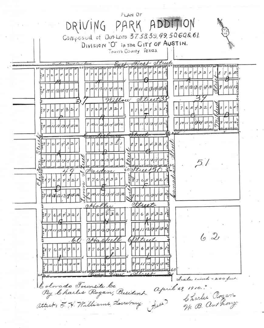
In Central Texas in the late 19th and early 20th centuries subdivision plats were by default recorded by one of the County Clerk's deputies laboriously copying the actual plat submitted for record. Sometimes, the surveyor or engineer who had laid it out or drawn it up got involved in the recording process and the copy in the records was of excellent, professional quality. Then there are instances like this 1910-vintage plat of a subdivision in Austin known DRIVING PARK ADDITION.
Whenever I see something like that, I wonder what the original plat really looked like. The Big Chief Tablet quality of the recorded version doesn't exactly inspire a great level of confidence in the quality of the surveying effort. By chance, I found the original of this plat today. It turns out to have looked like this:
One of the subdividers was a fellow named Charles Rogan who from 1899 until 1903 was Commissioner of the Texas General Land Office. Where did I find the original tracing of the plat? Why, in the holdings of the Texas General Land Office. The draftsman noted on the map was one "McD" who I'd think was more than likely a GLO employee named H.F. McDonald. I guess the perks of holding public office carried over into private life afterwards.
http://www.sacmaps.com/Subdivision/BOOK_010/001-001.TIF
Bungalow Tract has a picture of a Bungalow on it.
http://www.sacmaps.com/Subdivision/BOOK_010/042-001.TIF
The old maps looked nice but they show zero monuments, they are like a filed diagram for the Realtor.
J.C Boyd was a good surveyor.
Dave Karoly, post: 349597, member: 94 wrote: The old maps looked nice but they show zero monuments, they are like a filed diagram for the Realtor.
Does the open circle indicate a permanent monument with the rest of the corners being understood to be marked by redwood stakes or hubs?
Probably based on the practice of Joe Spink in the massive subdivision development of the 1950s. Those subdivision maps show very few monuments but the open circles on the street centerlines are usually occupied by an open 3/4" iron pipe. Spink appears around the 1930s so it could be assumed he got that from earlier local practice.
At some point I got the idea that the surveyor laid out the major control and the builders measured the lots in since everything was square. I do know if you go into some of those old lot and block subdivisions and split the curbs they will measure amazingly close to record. Then you measure out lots down the street and the lot lines exactly split the backyard garage pairs (usually about a foot apart). So they obviously used some control.
Dave Karoly, post: 349597, member: 94 wrote: http://www.sacmaps.com/Subdivision/BOOK_010/001-001.TIF
Bungalow Tract has a picture of a Bungalow on it.
http://www.sacmaps.com/Subdivision/BOOK_010/042-001.TIFThe old maps looked nice but they show zero monuments, they are like a filed diagram for the Realtor.
J.C Boyd was a good surveyor.
I've seen some Boyd surveys! I also can't stand that these old maps rarely, if ever, show any monumentation being done. There are parts of Stockton, CA that never had a monument set, not even a block corner, and now, retracement is done entirely by street improvements and fences.
Nice find! Looks like you're turning 90s.
In the County were we mainly work there are five subdivision, that were all done by the same developer. The Surveyor that done all of the work usually did a very good job on everything except these five. There were very few original monuments set, with a lot of blocks not having any and no mathematical way to get from one block to another.
Jones, post: 350298, member: 10458 wrote: In the County were we mainly work there are five subdivision, that were all done by the same developer. The Surveyor that done all of the work usually did a very good job on everything except these five. There were very few original monuments set, with a lot of blocks not having any and no mathematical way to get from one block to another.
[sarcasm]OH QUIT WHINING...IT HAS A VICINITY MAP SO YOU KNOW WHERE IT IS IN NORTH CAROLINA![/sarcasm]


