Jack Chiles, post: 417278, member: 24 wrote: Good morning, Kent.
So you would opine that all boundary surveys require research back to the deed(s) which established junior-senior rights for all of the boundaries of the tract being surveyed?
Do you feel that the Board is asking us to show said junior-senior deeds on the resulting plat?
JRC
Jack:
Sorry to be slow to answer, but I'm out in West Texas at the moment examining a major claim stemming (amazingly enough) from a surveyor evidently failing to do adequate research. To answer your question: I think it's a no-brainer that land surveyors have to know which tract is the senior grant in order to reconcile discrepancies in light of any prior right of possession. I had thought that under the existing rules, a professional surveyor should routinely note the original conveyances from common source of title that created the boundary in question so that those following his or her work can pick up from there.
Does it matter that the original conveyance was in 1838 instead of 2008? No, not in my view, and as time moves forward research is only getting easier in most counties, particularly the urban ones.
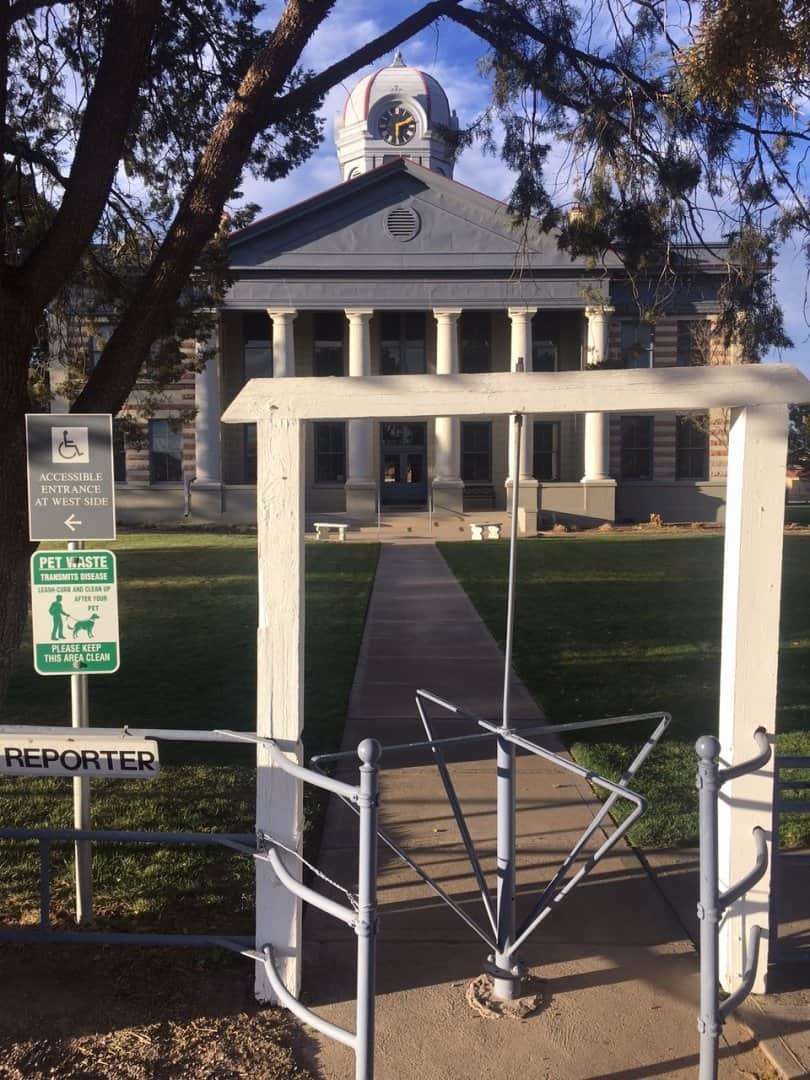
Can you guess which county courthouse this one is?
(Hint: that's an Alligator Juniper to the left of the turnstile)
From TX17. Your pic like it might be from around the corner on TX166...or somewhere thereabouts. Say howdy to the antelope and rattlesnakes for us.
paden cash, post: 417467, member: 20 wrote: From TX17. Your pic like it might be from around the corner on TX166...or somewhere thereabouts.
But wait; there's more!
@30.5411885,-103.8511336,3a,75y,270h,90t/data=!3m6!1e1!3m4!1schmxOS9jRW3Ibzgpe6sB8g!2e0!7i13312!8i6656?hl=en"> https://www.google.com/maps/ @30.5411885,-103.8511336,3a,75y,270h,90t/data=!3m6!1e1!3m4!1schmxOS9jRW3Ibzgpe6sB8g!2e0!7i13312!8i6656?hl=en
BTW, the Chihuahuan Desert Reseach Institute on the other side of the highway is definitely worth more than a four-hour visit and hike. (The best clue in the original was the dome of the telescope at McDonald Observatory that appears on the silhouette of the distant peak to the right of Blue Mountain.)
Kent McMillan, post: 417592, member: 3 wrote: But wait; there's more!
@30.5411885,-103.8511336,3a,75y,270h,90t/data=!3m6!1e1!3m4!1schmxOS9jRW3Ibzgpe6sB8g!2e0!7i13312!8i6656?hl=en"> https://www.google.com/maps/ @30.5411885,-103.8511336,3a,75y,270h,90t/data=!3m6!1e1!3m4!1schmxOS9jRW3Ibzgpe6sB8g!2e0!7i13312!8i6656?hl=en
BTW, the Chihuahuan Desert Reseach Institute on the other side of the highway is definitely worth more than a four-hour visit and hike. (The best clue in the original was the dome of the telescope at McDonald Observatory that appears on the silhouette of the distant peak to the right of Blue Mountain.)
Looks like a lot of limestone maybe. Is there enough water to have any caves in the area?
paden cash, post: 417595, member: 20 wrote: Looks like a lot of limestone maybe. Is there enough water to have any caves in the area?
The limestone begins more than 30 miles away, I think. That photo is all red basalt and other igneous effluvia. Tomorrow I'll be in the Edwards Limestone in Terrell County if things go according to plan on the return leg of the excursion.
Kent McMillan, post: 417434, member: 3 wrote: Jack:
Sorry to be slow to answer, but I'm out in West Texas at the moment examining a major claim stemming (amazingly enough) from a surveyor evidently failing to do adequate research. To answer your question: I think it's a no-brainer that land surveyors have to know which tract is the senior grant in order to reconcile discrepancies in light of any prior right of possession. I had thought that under the existing rules, a professional surveyor should routinely note the original conveyances from common source of title that created the boundary in question so that those following his or her work can pick up from there.
Does it matter that the original conveyance was in 1838 instead of 2008? No, not in my view, and as time moves forward research is only getting easier in most counties, particularly the urban ones.
Can you guess which county courthouse this one is?

(Hint: that's an Alligator Juniper to the left of the turnstile)
Hmmm, just from the tree, I'd guess whichever county Ft. Davis is in.
Shawn Billings, post: 417335, member: 6521 wrote: I see your point on the new wording Andy.
Apparently they had enough complaints on this proposed rule change that they revised the wording again. Sounds like they did the right thing to me.
Kent McMillan, post: 417592, member: 3 wrote: But wait; there's more!
@30.5411885,-103.8511336,3a,75y,270h,90t/data=!3m6!1e1!3m4!1schmxOS9jRW3Ibzgpe6sB8g!2e0!7i13312!8i6656?hl=en"> https://www.google.com/maps/ @30.5411885,-103.8511336,3a,75y,270h,90t/data=!3m6!1e1!3m4!1schmxOS9jRW3Ibzgpe6sB8g!2e0!7i13312!8i6656?hl=en
BTW, the Chihuahuan Desert Reseach Institute on the other side of the highway is definitely worth more than a four-hour visit and hike. (The best clue in the original was the dome of the telescope at McDonald Observatory that appears on the silhouette of the distant peak to the right of Blue Mountain.)
How in the world did you end up with that job way out there? That's a good little poke from Austin. Do you specialize in boundary disputes?
StLSurveyor, post: 429963, member: 7070 wrote: How in the world did you end up with that job way out there? That's a good little poke from Austin. Do you specialize in boundary disputes?
That's only about a six-hour drive from Austin. I was out there to investigate a major claim made on a title insurance policy that revolved around questions of boundary location. Interestingly, the Jeff Davis County Courthouse seen above was designed by the same architect who also was responsible for this one in Henderson County at the opposite end of Texas:


