[SARCASM]Learning to survey and interpret 120 year old survey notes online is a great start to determining your westerly land boundary.
You just need some of that fancy RTK equipment........
[/SARCASM]
You did a good job drafting up those examples.
---------
Had a guy come in last week with copies of his "survey maps". He had a forester helping him and they had already taped down the lines and verified that the occupation fit the survey pretty good. He only had one easement he was concerned about and wanted to find out if there were any other surveys that showed that easement. He was going to do some work with heavy equipment in that area and wanted to be sure.
Turns out all he had were assessor's tax maps and there were no recorded surveys in that area since the subdivision was first laid out 100 years ago.
It's scary the amount of liability some people are willing to take on.
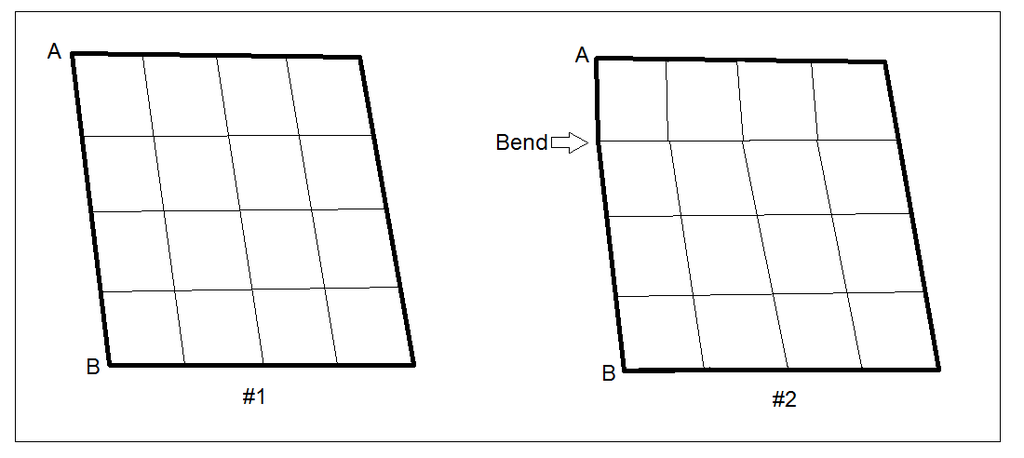
BM1002, post: 395479, member: 12198 wrote: I'm trying to figure out the western side of our land line and had some questions for any surveyors. Are section lines always straight from one corner of the sections to the next? I found supposed markers for both corners of the section, I just don't know if it's possible for there to be a bend in a section line (like #2) or if they are always straight from A to B for example (like #1)?
Also are sections always lined up at the corners (like #1), or can they be offset sometimes (like #2)? What about quarter sections, are they always lined up at the corners, or can they be offset (like at "D" below)? Any help would be appreciated.
BM1002:
These kinds of questions come up a lot on this forum. But really what someone, like yourself, should do is call or find a, or maybe a few, local surveyor(s), or at least some that are licensed or registered to practice in AL, and find one that wouldn't mind helping you out for a few hours. There are surveyors on this forum that are registered in AL, that I am sure would help you out. That is likely the best place for you to go from here. Some surveyors may charge you for research or consulting time, some may not, just depends on how much info you need.
Boundary Surveying, unlike some professions, can be very specific to an individuals State. From your OP you clearly have some knowledge of surveying...just make sure that you are getting advise, or knowledge from someone qualified, licensed, to give it.
Mack00079, post: 395555, member: 11516 wrote: The answer will depend on several factors.
1. Are you near a township corner? If so then yes the corners are sometimes offset.
2. Has their been a court judgement?
3. Are you sure you have found the correct corners?With question one you could be experiencing a township correction and or a section correction. The line you have in drawing two looks like the previous surveyor ( not the original surveyor ) did not understand corrections as per the time period the original work was done and decided to make it "correct". As for my number 2 we have a system where courts that know nothing of land law make judgements and sometimes those judgements lead to "new" section lines. I have worked in the Huntsville and surrounding area for eighteen years. I can say without a doubt that the sections in and around the mountain areas are neither square nor parallelograms. In reading original notes if you will email me the section township and range and the notes you have I would be more than happy to decipher to the amount I can. I will be at the ASPLS conference Wednesday through Friday if you are there feel free to bring the info with you and contact me. My email is mack00079@yahoo.com.
I am close to a township corner, no court judgement, and I believe I found the corners.
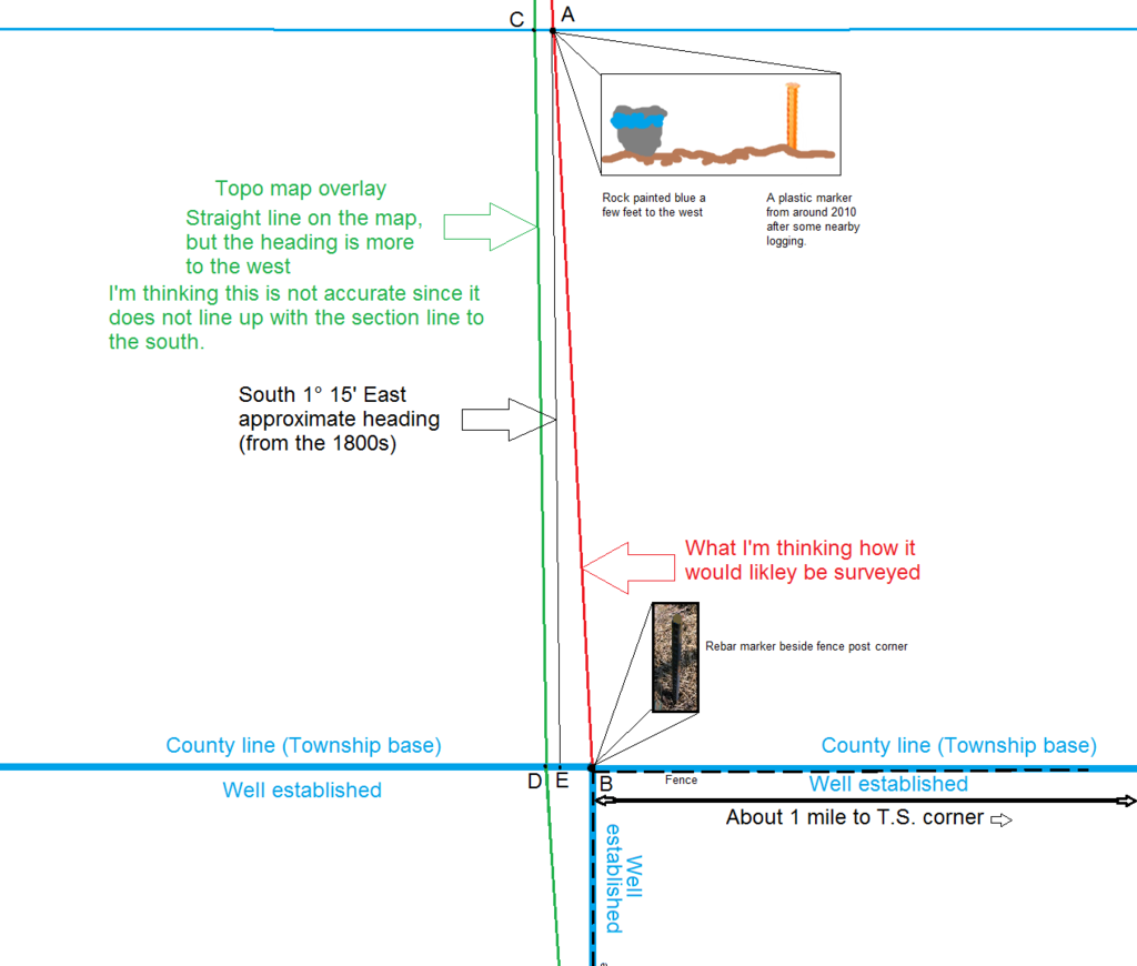
The many maps I've looked at online old and new all line up at "B" corner all the way across the county line (such as the topo maps and #1 I drew). The only map that did not line up is the GIS tax map sites for the two different counties. The county to the south has it's GIS tax map lined up perfect with the fence line, but the county to the north lines up just like the topo map (both do not continue north or south over the county line). This GIS map for the northern county side has large errors offset to the west along the entire line even at "A", again just like the topo map.
I'm thinking the topo line location is a large error because a previous survey in the 1980s the cut tree line was well to the east of the topo line (over 130 feet to the east) and lined up almost perfect with the red line. So I think I found the proper corners.
If a surveyor agreed with these two section corners, could there still be a slight bend in the section line if one quarter section property corner was ever found from the 1980s along the section line between A and B, or would the modern day measurement from A to B override that old marker that would give a tiny bend in the section line?
If that maker was never found at the quarter, I assume the new quarter section corners would fall precisely along the accurate modern day measurement between A and B, does that sound right?
Thanks everyone for the help, here is a illustration I made to show what I'm seeing:

The answer can old be had by a true and correct survey run on the ground by someone licensed to survey and who has the knowledge and special skill in Public lands Surveys. Line run and marked upon ground cannot be changed by a surveyor or even a court of law. Thee is no error in the original monuments set as part of the original survey according the laws of the US enacted in 1805. Cragin v Powell instructs us that the plats and field notes are as much a part of the grant as if they had been attached to the deed. The original monuments may or may not answer the question of whether or not the line has a bend in it. One needs to find original monuments provided that there are undisturbed. The entire process is an evidentiary process that involves more that just calculation and measurement. I have never set foot in AL, but I can tell you this the plastic stake and rebar are NOT ORIGINAL CORNERS. Evidence may prove them to be acceptable locations
Dave Karoly, post: 395497, member: 94 wrote: A line run with a compass is not straight, I guarantee it.
it is fir a bit
You are not going to find an absolute answer to your problem until you get a surveyor involved that will look at ALL the evidence.
The answer to all of your questions will be "it depends".
2 comments. You are certainly an interesting fellow, coming on this forum, with about 1/2 the facts, and all your research.
1.) You know enough to be dangerous, 2.) and you don't know enough to do it right.
Now, you could really get interesting, if you knew how to run precise surveying equipment!
Suggestion, take your folder of info, and take a local surveyor to lunch. Buy him something nice, and just enjoy a long lunch. You will both leave the table, with something.
Nate
DANEMINCE@YAHOO.COM, post: 395651, member: 296 wrote: but I can tell you this the plastic stake and rebar are NOT ORIGINAL CORNERS. Evidence may prove them to be acceptable locations
That is the danger. The only way you will ever know if those positions are acceptable is if you get a local surveyor involved. At this point there is no way to even know if those "mouments" were even intended to be the corners you think they are.
I know a well qualified surveyor in end would have the final say on markers ( I would like this if cost is not too much for marking two points), I was just curious on some issues. The surveying field is likely what I would have gone into if it weren't for the math, I'm not good at mind number calculation. Thanks for the help everyone.
You can go to your local bookstore, buy a bible, (or a comic book), and start your own religion.
In some cases, land surveyors are that way too. (lots of differences)
But, amongst the more studicious, and professional, usually there is little difference.
If you do it yourself, (save money!) or try to flush out the least expensive surveyor, you often will wind up with the dregs of the jug.
With all the research you have done... Have you gone and survey shopped yet?
We'd all like to hear the results, if you do that!
I'm not real great at "in your head" math... Calculators are for me.... 🙂
It used to be that "Higgins" survey instructions was taught in high school.
I wouldn't let that hold you back. The math part that is.
There is a huge difference between the price paid for professional services and the true value of knowing the truth about your real estate. Until one understands that difference it all seems like shopping for pork and beans at the grocery store.
Holy Cow, post: 395888, member: 50 wrote: There is a huge difference between the price paid for professional services and the true value of knowing the truth about your real estate. Until one understands that difference it all seems like shopping for pork and beans at the grocery store.
"The title to your real property is no better than your survey."
- Wise old surveyor sage


