Brian Allen, post: 371228, member: 1333 wrote: The "intentions of the surveyor" are usually completely irrelevant. It is the intentions and actions of the landowners that establish the location of boundaries.
I am talking about the contents of mapping. Certainly, if the intentions of the parties are not faithfully mapped, then how are we to know that the mapping is consistent with those intentions. You are mistaken to think that I am suggesting that extrinsic evidence can add to or subtract from the intentions of the land owners. A retracing surveyor considers all the relevant evidence in the formation of the professional opinion. Perhaps you ought to have asked me to explain my view rather than assuming I do not know what I am talking about.
Nate - I think adding some deed/easement references and owner names would add usefulness to your record of survey.
I was also wondering about the found axle. What is the significance of showing that when there no information given as to it's position or relation to your survey?
Brian Allen, post: 371228, member: 1333 wrote: The "intentions of the surveyor" are usually completely irrelevant. It is the intentions and actions of the landowners that establish the location of boundaries.
I am talking about the contents of mapping. Certainly, if the intentions of the parties are not faithfully mapped, then how are we to know that the mapping is consistent with those intentions. You are mistaken to think I am speaking of any other thing than what exactly is on the face of the map. PLEASE READ CAREFULLY EXACTLY WHAT I WROTE AND DO NOT TRY TO READ IT AS SOMETHING ELSE. My comment has to do ONLY with weighing the evidence of a map. If there is a previous survey, be it the creating survey or a subsequent retracement, then it is part of the evidence that must be considered and given its proper weight. Just as monuments found at or near the corners being retrace must be properly weighed whether they are called for OR NOT. The actual problem with the profession is that the evaluation of evidence is not well understood. Many surveyors seize upon some limited understanding of the duty of surveyors and then they insist upon applying this principle or that principle to the fact set before them in an inflexible manner come hell or high water and to the exclusion of common sense. There are rules and then there are exceptions to the rules and then there are cases where neither the rules nor the exceptions to the rules apply.
Mr. Digger, the Axle is shown on the RW Zickwolf plat. It shows them graphically, for the purpose of letting others know that I considered it. I tied those corners. I also tied a BUNCH of other mons, in this quasi Sub. So, I know the general pattern of monuments. I have also been to a scrap metal yard, collecting rebar, etc. And, there is some mental association, that happens while you are there. When you grow up surveying, as I did, you think of an old axle, and there is a nice one, at the scrap yard. It sort of finishes the picture, as to what was underground. Also, since this is a source of "Cut rate, but often high quality" monuments, the reference to "Cooks Scrap Metal" brings a complete smorgasbord to mind, with a whole cacophony of survey monuments. When Mr. James O Tallent, went to the scrap yard, he did the same thing. He was monument shopping. Kind of like "Instant Bernsten, right down the street".
He would have picked up MORE than pinch tops.
It's just the nature of things. How it worked.
I met Mr. James O Tallent, sometime in the 1980's, and considered him to be "The sloppy surveyor of Caddo Hills Estates". Now, I'm yielding to his markers. I want to share this part of my personal journey. It is a process of REALIZING that it is not the PERFECTION of his work that counts. It is the Legality.
That's part of why I started the original post, in the first place.
Carry on.
N
imaudigger, post: 371444, member: 7286 wrote: Nate - I think adding some deed/easement references and owner names would add usefulness to your record of survey.
Note the other plats linked, by Dan Robison. Some of them are there.
I can post more.
N
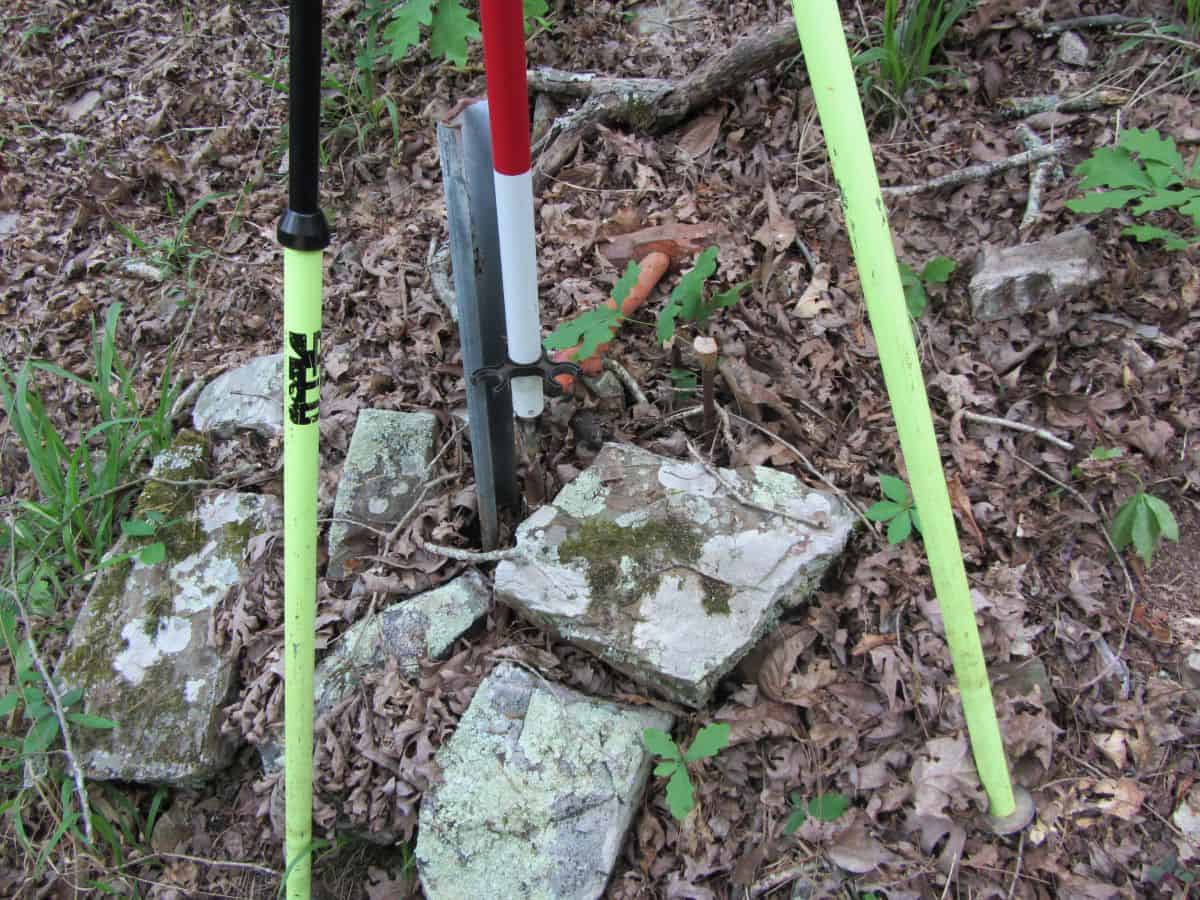
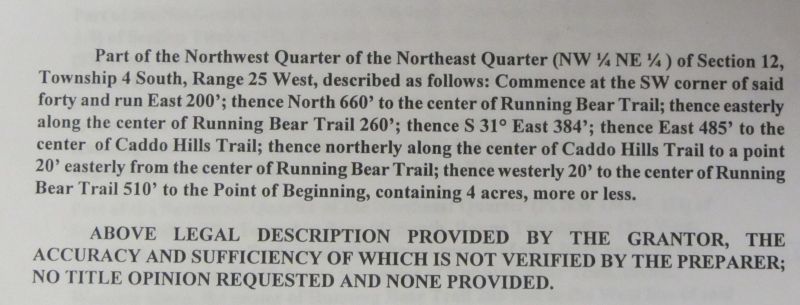
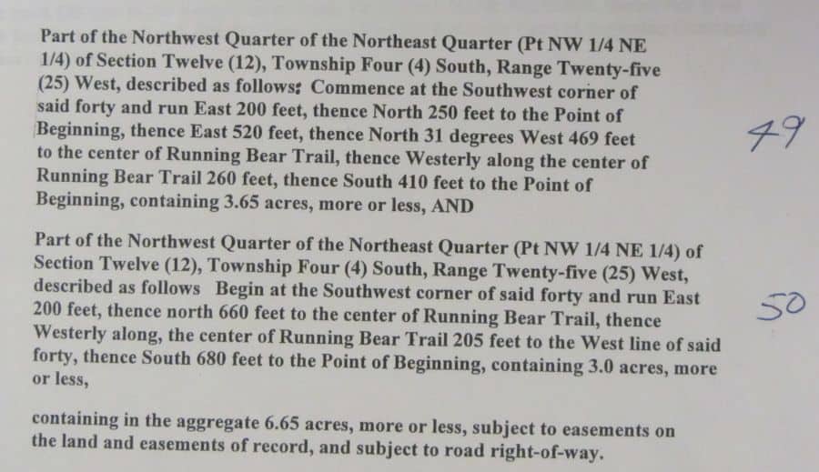
Here is corner "D", as shown on my plat. It is a 1/2" Pinch Top Pipe  And, here are the previous descriptions, for the parcels shown on my plat.


The calls for the roads, etc are real. I have others too.
I have one that calls for the actual tract number, included in the meets and bounds desc.
N
Tommy Young, post: 371419, member: 703 wrote: Measuring ability has nothing to do with this.
Measurement is always a piece of evidence, we're Surveyor's. No one said it was the highest form of evidence, but evidence none the less.
Well, I guess so. If it was in Texas, or even in Pike County, it'd be too far off, so I stand corrected! 🙂
N
Nate The Surveyor, post: 371466, member: 291 wrote: Here is corner "D", as shown on my plat. It is a 1/2" Pinch Top Pipe
And, here are the previous descriptions, for the parcels shown on my plat.


The calls for the roads, etc are real. I have others too.
I have one that calls for the actual tract number, included in the meets and bounds desc.
N
Of course. The only thing unpredictable from your original post was whether STJ would show the monuments he/she disagreed with. I gave it a 50/50 chance. The fact that STJ actually located them, and in addition actually showed them on the map, might mean all hope is not lost. Maybe you can bring him into the fold of real surveyors yet.
STJ is passed away. So is James O Tallent (C&T) SJT had a party chief doing alot of his work though... and he's around someplace....
I was did not intend on letting the actual names of the involved parties get out.
Just out of... well, they are not alive, to speak for themselves.
N
MightyMoe, post: 371425, member: 700 wrote: I did quite a bit of stadia for topo......there is no reason to see 200feet miss by 9 feet, but that's kinda what I'm seeing also. I always figured those points were a single tie from stadia control and it compounded the errors somehow
While the fellow regularly used stadia, he may have paced that line off.
Nate The Surveyor, post: 371465, member: 291 wrote: Note the other plats linked, by Dan Robison. Some of them are there.
I can post more.N
I meant that providing reference to the legal documents that you relied upon would be useful to other professionals following your work at a later date.
It's something I'm used to seeing on recorded surveys.
roger_LS, post: 371474, member: 11550 wrote: Measurement is always a piece of evidence, we're Surveyor's. No one said it was the highest form of evidence, but evidence none the less.
I don't disagree, but too many surveyors are ranking it way too high.
ItÛªs still the same old story/ A fight for love and glory...
The reason I started this thread, was to give some of the newcomers, permission to "Think outside the box". To consider the REALITY of the situations, that they encounter, and to look at things from a "Purely legal point of view", and to let the math go to aside, (Not out of state, or too far... ok? Thanks Roger!) while they analyze, and think.
It's part of our job... to consider things from differing points of view.
And, IF you document, what you did, well, it makes you "re-traceable, and follow-able". That is, you actually are serving in the capacity of a surveyor.
And, I am sure that more will come along, that will add to what I have done.
Enjoy your surveying. Te Deum!
Nate
imaudigger, post: 371484, member: 7286 wrote: I meant that providing reference to the legal documents that you relied upon would be useful to other professionals following your work at a later date.
It's something I'm used to seeing on recorded surveys.
[USER=291]@Nate The Surveyor[/USER]
Nate,
Might I suggest labeling the lines with the 'record' bearings/distances?
Where different, show both plat and deed.
I think showing measured and record for not only the boundary but also the interior lot lines would demonstrate your analysis (and also shed light on how SJT came to his conclusion).
:gammon: East line of Lot 50
:gammon: West line of Lots 48 and 49
:gammon: Common line of Lots 48 and 49
Did the actions or beliefs of the owners of Lots 48 and 49 have anything to add to your analysis/opinion?
DDSM:beer:
Nate The Surveyor, post: 371493, member: 291 wrote: The reason I started this thread, was to give some of the newcomers, permission to "Think outside the box". To consider the REALITY of the situations, that they encounter, and to look at things from a "Purely legal point of view", and to let the math go to aside, (Not out of state, or too far... ok? Thanks Roger!) while they analyze, and think.
It's part of our job... to consider things from differing points of view.
And, IF you document, what you did, well, it makes you "re-traceable, and follow-able". That is, you actually are serving in the capacity of a surveyor.
And, I am sure that more will come along, that will add to what I have done.Enjoy your surveying. Te Deum!
Nate
That is correct.
Some of us have been taught that a description with no calls for monuments can never be finally monumented, all monuments are off a little bit. This is incorrect. Once the tract is monumented, and no one objects within a reasonable amount of time then we should be accepting those monuments, not setting more or setting virtual pin cushions.
Nate The Surveyor, post: 371449, member: 291 wrote: Mr. Digger, the Axle is shown on the RW Zickwolf plat. It shows them graphically, for the purpose of letting others know that I considered it. I tied those corners. I also tied a BUNCH of other mons, in this quasi Sub. So, I know the general pattern of monuments. I have also been to a scrap metal yard, collecting rebar, etc. And, there is some mental association, that happens while you are there. When you grow up surveying, as I did, you think of an old axle, and there is a nice one, at the scrap yard. It sort of finishes the picture, as to what was underground. Also, since this is a source of "Cut rate, but often high quality" monuments, the reference to "Cooks Scrap Metal" brings a complete smorgasbord to mind, with a whole cacophony of survey monuments. When Mr. James O Tallent, went to the scrap yard, he did the same thing. He was monument shopping. Kind of like "Instant Bernsten, right down the street".
He would have picked up MORE than pinch tops.
It's just the nature of things. How it worked.
I met Mr. James O Tallent, sometime in the 1980's, and considered him to be "The sloppy surveyor of Caddo Hills Estates". Now, I'm yielding to his markers. I want to share this part of my personal journey. It is a process of REALIZING that it is not the PERFECTION of his work that counts. It is the Legality.
That's part of why I started the original post, in the first place.
Carry on.
N
In the space below your report paragraph, it would be helpful to
List your reference plats with book/page #. That would provide a tie to the axle on the Zickwolf plat.
As of now, there is no reference to said axle. Don't mean to be picky but more concise info is always better.
Carry on
Nate The Surveyor, post: 371479, member: 291 wrote: STJ is passed away. So is James O Tallent (C&T) S
Just out of... well, they are not alive, to speak for themselves.
N
Their plats should provide the info to speak for them.
Thanks for all the helpful suggestions. What I have posted here... is not quite the final... I have a number of things to add. I set some steel fenceposts around the perimeter. Trouble is, I was not intending to post it... When I made the op.
But, no matter there.
I have a deadline tomorrow, at 5 pm, and so I am a bit distracted.
No matter. The basic stuff is there. Some of my posting has been from my phone... and that is not as handy. I won't be back at this computer for a few days, starting tomorrow night.
N


