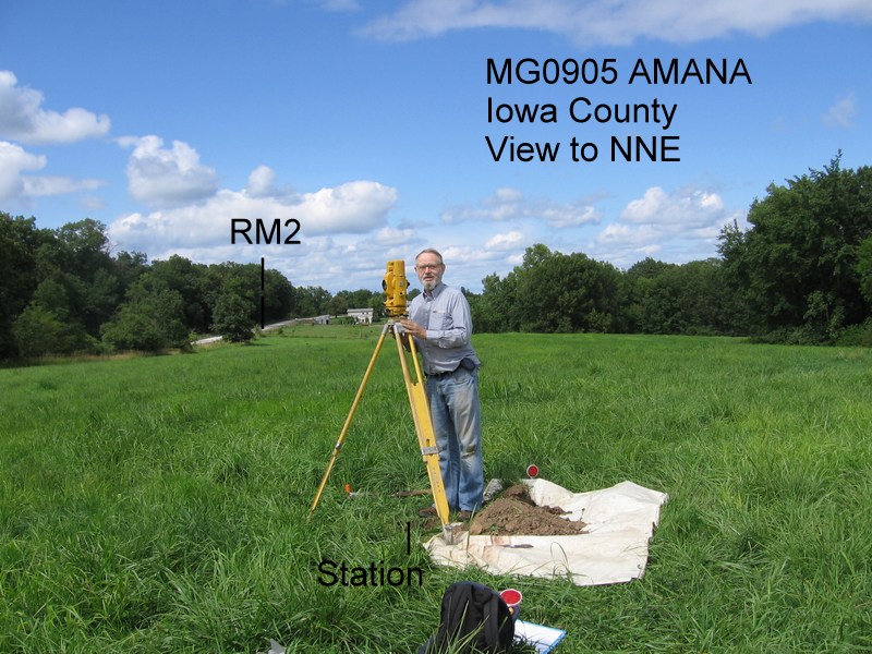
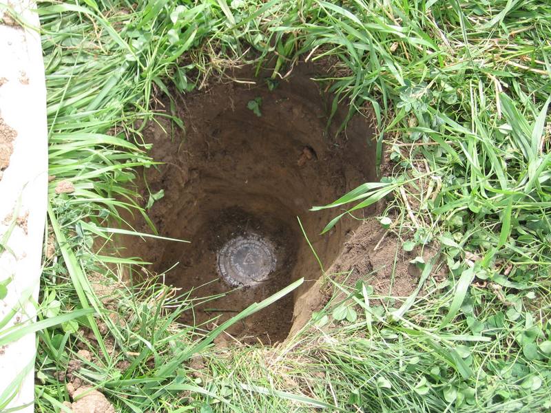
It's not a Jerry Penry level achievement, and maybe routine for some of you. But I don't get to play surveyor every day, and I want to show off my 1930 triangulation station find.
It was a little more challenging than the typical triangulation station that, even if it isn't visible, is usually within a 100-foot tape of its reference marks. This one was 131 ft and 708 ft from its RMs and 16 inches down.
I had thought I wasn't going to find RM1 and would have to bring azimuth in to RM2 from distant towers over a hill. Polaris isn't visible from either RM and although I've done sun shots, I'm not practiced at it.
Then the metal detector found RM1 slightly buried. I went to the station coordinates by handheld GPS, set up the obsolete instrument (GTS-2B), and measured distance to each RM. The GPS was off about 6 feet. I measured off the differences and repeated. The ground was too hard to readily probe the depth of the disk, but the measurements turned out to be good enough.
I left iron beside the concrete that is sufficient for a magnetic locator.
I was disappointed that I couldn't identify the blaze on what appears to be the right giant oak tree.

I always find it amazing how control points like this get buried
Bury a magnet next to it and it will sing like a canary.
SWEET!
Good job Bill.
> I always find it amazing how control points like this get buried
Well, in 1930 the mark was reportedly "1 foot below the surface", so the amount of soil accumlation since then has been only a few inches.
[pre]
MG0905'DESCRIBED BY COAST AND GEODETIC SURVEY 1930 (FLG)
MG0905'STATION IS ABOUT 4 MILES N AND 2-1/2 MILES W OF HOMESTEAD,
MG0905'3-1/2 MILES W AND 1-1/4 MILES NE OF THE VILLAGE OF HIGH AMANA,
MG0905'6 MILES S OF THE TOWN OF NORWAY IN THE SW 1/4 SEC. 17, T 81 N,
MG0905'R 9 W, ON LAND OWNED BY THE AMANA COLONY. IT IS IN A SMALL
MG0905'CLEARED PLOT IN THE WOODED LAND, ON THE HIGHEST GROUND ABOUT
MG0905'40 FEET E OF THE ROAD FENCE AND ABOUT 125 YARDS SW OF A DESERTED
MG0905'HOUSE AND BARN. IT IS ABOUT 1/4 MILE S OF THE T-ROAD LEADING
MG0905'E. THE MARK IS 1 FOOT BELOW THE SURFACE.
[/pre]
I'm frankly a bit surprised that soil erosion hasn't reduced the cover on the mark. I wonder if that isn't more of a result of the field being in Amana Colony without nearly a century of mechanical plowing.
Sometimes I wish we had a similar Landsurvey system with good reference points.
Our section borders are not marked, most of them follow the natural canals or roads, but these borders have no legal value overhere.
Thnaks for sharing the pictures, nice place for some searching!
Christof.
This monument is not connected in any way to the land survey system.
It is a geodetic horizontal control station that was important in the triangulations across the US. It is unlikely that anyone will ever make serious use of it again, now that we have GPS, but I like finding and reporting the condition of both bench marks (important) and triangulation stations (not so important) that are in the NGS data base.
It was common C&GS practice, especially in the 1930's, to place triangulation stations on a hill just inside a farm field, with reference marks at the road fence. Since the field would be cultivated, they put the station disk below plow depth. The buried location would be very stable and protected from damage.
As Kent indicated, in many cases the cultivation and erosion over the decades reduced the soil depth on ridges, and the farmers sometimes removed the troublesome "rock" their machinery hit.
In this case, I suspect the area was often plowed from the late 1850's to the mid twentieth century. However, the irregular area between the trees does not fit so well with modern farming practices that prefer straight quarter-mile rows, and I'm not surprised to now find it a hayfield.
This disk somehow went from "1 foot" in 1930 to "16 inches" in 1958 and again in 2013. Accumulation of plant material would build the depth over decades, but probably not 4 inches between 1930 and 1958.
My brother and I once found another triangulation station where the concrete of the main disk was lying at the corner of the field (disk missing), because it had become an obstacle. We were able to find the "backup" underground disk 29 inches below the surface. My arm was just long enough to reach in the hole and clean the disk, but it was a stretch.
http://www.ngs.noaa.gov/cgi-bin/ds_mark.prl?PidBox=le0530 

That is awesome. I love to find those old marks and report them too.
This reminds me of something I saw on the NGS site a few months ago. It shows areas of uncertainty in the current geoid model:
http://www.ngs.noaa.gov/web/news/Surveyors_Take_Active_Role_in_Future_of_NSRS.shtml
Of course you have to have GE and DSWorld to view the map but it is interesting to say the least. I think I may get back into this in the future, with my son, when I get back to my Old Kentucky Home. I know where several vertical points are that I can easily get to and observe.
Ok, I understand.
We have the same old points, wel documented concrete poles at soil level!
They were only used for public works, you setup the totalstation and took a backsight at one of the sightable church-, water- or radio towers, most of them are part of the geodetic system. We have churches everywhere here. It was very common, when no groundpoint was available, to do a resection on a number of church towers ... the good old days I guess, we now have RTK-GPS all over the country.
Chr.


