


A couple weeks ago I saw a demonstration of an iPhone app which measures the quantities of stockpiles.
The company that developed this worked with Kniferiver on a bunch of stockpile sites in the Portland area and throughout the northwest to perfect the program. They say they hit within 1% to 2% of LIDAR measurements.
The tool is an iPhone 5 or 6 app and once the measurement it complete, you up load it to the company’s web site. It is then processed and I believe they say in 18 hours you have your quantities and tonnage (based on the factor you give them). We measured this pile at noon and it was available the next morning. The cost is something like $50 a pile. The app is free, you buy a subscription to have the data processed.
Briefly, two traffic cones are placed 25 feet apart in front of the pile. You start filming with the iPhone in video mode at the right-hand cone (#1), walk clockwise past the left hand cone (#2), and continue around the pile. You finish by overlapping your filming past cone #1 and end at #2. The phone has to have GPS activated. When you start walking the pile the program methodically beeps, letting you know that you are doing OK. If you turn the camera away from the pile, are too shaky or in some other way do something the phone thinks is weird, it buzzes and beeps and farts out warnings. Once the measurement is complete it will identify sketchy areas and let you review the short video clip of these areas
Cones. The distance from the cones to the pile does not matter. You just have to be sure the cones are 25 feet apart:
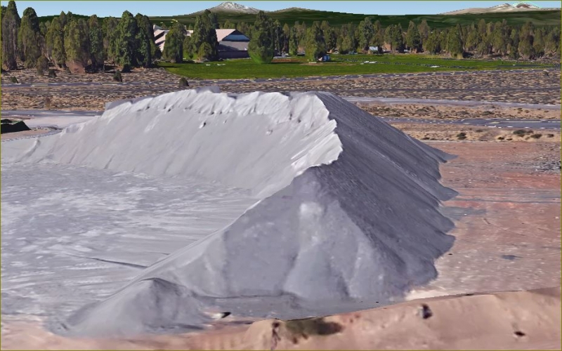
Videoing a pile (different pile from the one shown below):
Your distance from the pile can vary along your circumnavigation, just as long as you have the bottom and top of the pile in the screen. The video is shot in portrait format:

Another nearby pile necessitated scooting in closer to the measurement pile which meant top and bottom could not be filmed. They said to keep the top in view. Once the constriction ends you drift away to get the top/bottom view again. I believe it then interpolates the missing segment along the toe of the pile. This happened for about 50 to 80 feet on the pile we measured:
You do not film the top of the pile. They said they offer other methods of measurement for piles that are dished in or have significant volume heaped up beyond the “false summit” you view from the ground.
Here is a clip of the report from the test stock pile (13,550 cu. yd.):
The next day we measured the pile. Over 500 shots. Here’s our measurement (13,148 cu. yd.)
I made a volume DTM from our work and contoured it to get "fill contours" (rather than elevation contours)and then roughly scaled/rotated an image clipped from the iPhone contour pdf into the Acad drawing to compare (note that after we measured the pile the contractor began hauling loads out of it. You can see the difference in the “face” of the pile as noted below. The decreased yardage was nominal.) The black 1 foot contours are the iPhone contours and the blue are the survey measure 5’ index contours:

Here is a rough oblique view rendering of the pile from the SW, the "face" is on the left. The top had a bunch of 1 to 3 foot hummocks:
> A couple weeks ago I saw a demonstration of an iPhone app which measures the quantities of stockpiles.
>
> The company that developed this worked with Kniferiver on a bunch of stockpile sites in the Portland area and throughout the northwest to perfect the program. They say they hit within 1% to 2% of LIDAR measurements.
It's a cool idea, definitely worth the cost. It would be interesting to test the method by simply repeating the measurements on the same stockpile, but with a fresh layout of traffic cones, to see whether the two volumes agreed within 1% to 2%. iMortgageMapper can't be far behind.
I agree and mentioned that they should let a company send in two videos of the same pile to get a redundancy check. As I understand it, you only get one upload per pile, unless you want to pay twice (still inexpensive).
TxDot & iPhone stockpile measure
Oh, this just in... for more information you can talk to your friends at TxDot about this service.
TxDot & iPhone stockpile measure
> Oh, this just in... for more information you can talk to your friends at TxDot about this service.
>
>> https://www.stockpilereports.com/news/txdot-awards-stockpile-reports-statewide-contract-measurement-materials-using-iphone/br >
Looks as if they may need some training on 25 ft. o.c. traffic cone control point placement.
TxDot & iPhone stockpile measure
This is an intriguing application.
I'd definitely want a second opinion from a retake of images. I would have thought the company would welcome that, unless they are so confident of their product as to not warrant a second measure.
How accurate is the 25' meant to be?
Curious what colour and texture affects the output?
A dense black coal pile for example, or smooth white clay, bentonite etc.
Wonder how that would go modelling a quarry face. Need some adoption but same principles apply.
Just need cones at both ends perhaps?

Excellent post.
TxDot & iPhone stockpile measure
>I would have thought the company would welcome that, unless they are so confident of their product as to not warrant a second measure.
I think they've go this so tuned in that what you said is the case. However, I just saw the demo and didn't wheel and deal with the representatives. They may be offering training followed by other checks so customers can become proficient and gain confidence with the product. I'm not sure. The representatives who demo'd the product were great. Both are 2007 graduates of Oregon State and have extensive survey and GIS and imaging (obviously) experience.
> How accurate is the 25' meant to be?
Not very. Just with a cloth tape. They recommend setting up two cones 25 feet apart and then drilling holes in the bases and connecting them with non stretchy rope so they will be 25' every time you set them up. That's what you see in the photo above.
> Curious what colour and texture affects the output?
> A dense black coal pile for example, or smooth white clay, bentonite etc.
I guess they had problems modeling a pile of pure white golf course sand in Florida. I asked if you had a water hose and could zig-zag the pile with a water stream if that'd work and they said probably so.
> Wonder how that would go modelling a quarry face. Need some adoption but same principles apply.
> Just need cones at both ends perhaps?
Maybe.
Very cool. Good use of cloud processing.
TxDot & iPhone stockpile measure
> Wonder how that would go modelling a quarry face. Need some adoption but same principles apply.
> Just need cones at both ends perhaps?
More on you observation Richard. When I saw the detail the iPhone got on the Mt. Rushmore-like* face of the pile I thought that, if you had lath, stakes, pin flags or the like marking a couple points you had coordinates on, a surveyor could accurately topo, via photography, very complex features like rock outcrops, cliffs, et cetera in no time flat without having to use a scanner. Then you could bring the 3d data into your work and using the common points, splice it into your surface. I hadn't thought of cones at both ends... not sure how all that is resolved with the software that grinds this out. I didn't ask the reps if they can do an open ended video. If not, I'm sure the answer would have been "soon".
I believe google earth is using the sort of photo 3D mapping/rendering technology based on the screen shot below of another nearby stock pile (now gone) when viewed oblique with 3D buildings checked:
* For all of you in the Southern Hemisphere, Mt. Rushmore is a sculpted cliff face in the USA depicting 3 surveyors and a myopic cowboy: http://en.wikipedia.org/wiki/Mount_Rushmore
Looks like as a tool in a Surveyor's or Photogrammetrist's hands it could prove to be cost effective.
My question is do they have any licensed professionals on staff? I think a case could be made that they are practicing Land Surveying or Photogrammetry as per Oregon Statutes 672.
That's an interesting point John. At what point does a service supporting a profession become the actual practice of the profession. When NGS provides a coordinate on an OPUS return, has NGS surveyed without a license? It's not entirely equivalent but I can see your case. Perhaps so long as a PLS reviews the result before providing it to a client the law is satisfied.
Gavin and Shawn
If all they were doing was generating volumes from photos sent to them you might be right but they apparently also offer aerial photogrammetry which needs a license in Oregon.
Here is a quote from their website:
"Aerial photography for stockpile measurement is an exclusive benefit to subscribers to the Stockpile Reports service. Customers simply contact us when they wish to have a flight performed, and indicate the site(s) to be measured. Aerial photographers are trained and certified by Stockpile Reports on optimal image capture, performing flights for customers around the USA."
For what its worth, I sent an inquiry to the Oregon Board a few hours ago to see if they would venture an opinion.
> It is a tough line to define... what does or does not fall within the state's definition.
FWIW removing stains on teeth fell specifically within the state's definition of practicing dentisty in North Carolina when the Supreme Court ruled this week that regulating it was a violation of the Sherman Antitrust Act.
Why should it be regulated? I don't see any reason that it should require a license.
TxDot & iPhone stockpile measure
Always admired those sculptures as a kid. Amazing.
Once we considered the best way to survey a very rocky cliff by the coast for roadworks.
Idea came to involve 2 good SLR cameras and take overlapping images and use photogrametry.
Unfortunately it never came to fruition.
This opens up a whole realm of possibilities.
The mind boggles.
Well worth keeping an eye out for.
Here stockpiles are generally but not always, measured by registered Land surveyors, or at least they have to be signed off by one.
Not sure how this use would work if surveyors don't have control of the software? But then it's only software.
Haven't really decided how I'd approach this if I had to use my expertise and 'status' to undertake a measure up for contract or dispute if this was readily available.
That said, as mentioned below photogrametry is acceptable so why not this? It's another modern form of digital photogrametry. Probably answered my own questioning.
Why should it be regulated? I don't see any reason that it should require a license.
:good: :good:
That's just plain silly and borders on preposterous. Anybody who believes that a state board is going to regulate the computation of stockpiles when the onus, risk and liability falls completely on the contractor obviously doesn't understand the industry.
Edit: Unless it's written into the contract that quantities need to be verified by a Licensed Surveyor and then it's a contractual and not a statutory issue. Other than that it's an agreement between 2 parties. Stock Pile Quantities are a pay item and how the owner decides to verify them is on him/her, not the State Board.
In the event that a BOR issues a ruling requiring Licensure, it'll probably take all of 10 minutes for a competent court of law to simply say "WTF are you talking about Willis?" 😉

"I don't see any reason that it should require a license."
It falls under the definintion of Land Surveying in Arizona.
Ralph
Here in Oregon the law states the practice of surveying includes among other things:
(d) Surveying to establish lines, grades or elevations, or to determine or estimate quantities of materials required, removed or in place.
> "I don't see any reason that it should require a license."
>
> It falls under the definintion of Land Surveying in Arizona.
Really???
I'd like to see that enforced.