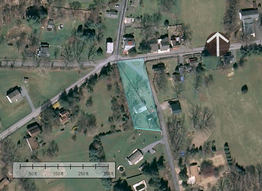
Kent McMillan, post: 444733, member: 3 wrote: As the whole picture starts to emerge, some of the details make a bit more sense. Here is a sketch of the two triangles of land mentioned by the original poster. The true bearing of the paved road running East and West scales as about N84?ø20'E in modern georeferenced aerial orthophotos. This would be the same line that was described as having a bearing of N87?ø45'E in the OP. So the bearing basis of Triangle B would appear to be a "North" direction with a true azimuth of N3?ø25'W. That would give the hypoteneuse of Triangle B a true bearing of N32?ø25'W, which is within a few minutes of what one would estimate for the true bearing of the same side of Triangle A
One odd feature of the improvements on the site is the angle at which the structure is sited. However, it appears to be all on Triangle A and roughly perpendicular to the hypoteneuse.
I took a quick look at the deed yesterday. I believe at least one of the calls was for a stone in the road. Could be mixing it up with another deed though, I was chasing down descriptions from the 1830's all day yesterday.
That "Y" in the road on the lot is a pretty common occurrence around here when the parcels front roadways and predate the automobile.
Several more things...
Where is the 1982 plat? If it's online post a link.
Surely, there we could have a look at some info from the Road Dpmt. Or Highway Dpmt.
There may be some references to the stones there....
James Fleming, post: 444742, member: 136 wrote: I took a quick look at the deed yesterday. I believe at least one of the calls was for a stone in the road. Could be mixing it up with another deed though, I was chasing down descriptions from the 1830's all day yesterday.
That "Y" in the road on the lot is a pretty common occurrence around here when the parcels front roadways and predate the automobile.
Yes, an examination of the records of the establishment (and alteration) of the roads along and across the parcels of interest would be pretty much required, I'd think.
It's possible that some of the original language of the descriptions has been stripped out of the same when copied in subsequent conveyancess, so actually examining the original severing conveyances would also be required.
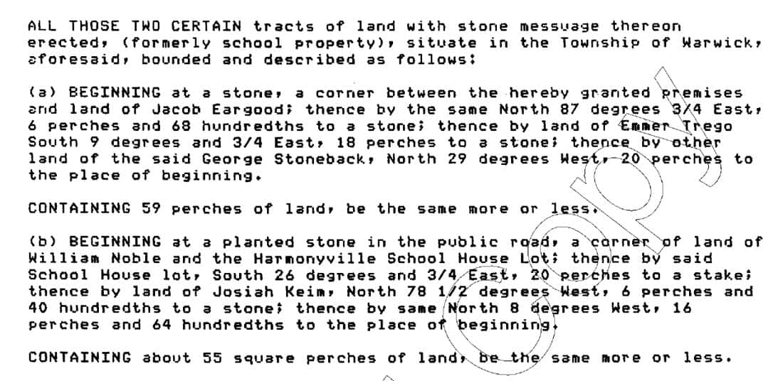
Oh, this one would have been much easier had we the actual language of the conveyance to begin with. Here it is from a deed executed in 1995, plainly a transcription of much earlier deeds.
What these almost certainly represent are two original conveyances of lots for a school in Harmonyville. The first one would cover the site where the school house is shown upon the 1873 map that I posted earlier and the second is of the land acquired (probably in about 1882 from George Stoneback on the West side of what is now S Hill Camp Road.
Generally, these descriptions confirm the essential elements of the sketch I posted above.
The first description mentions a George Stoneback as a landowner. Per the Proof of Death Register for Chester County, PA: George Stoneback died in Warwick Township in 1880. So the first description almost certainly predates that and, since the school house is shown in place in 1873, almost certainly predates 1873.
The first description also mentions an Emmor Trego. The US Federal Census of 1870 reported an Emmor Trego, age 81, living with his son, Albert Trego, in Warwick Township (Post Office = Cupola). Emmor Trego reported that he owned real estate worth $1500 and had a person al estate of $2500, so he was a landowner in 1870 and before, presumably.
If half of what you report about the company that did your "survey" is correct there is a serious lack of something. I suspect the fee you paid was in the hundreds, not the thousands, that's the first sign that what you are getting isn't worth much. I also suspect that the person you talked on the phone was an office tech or a drafters, not a surveyor. Either way there seems to be no competent individual exercising responsible charge.
You are likely going to have to hire a different surveyor to figure this out. I would put thought if lawyers on the back burner. An attorney can't tell you where your boundary is.
BTW, I think that the relevant subdivsion map was recorded as Plan B-80-105 in Chester County, PA, but I haven't yet been able to find it available for download, possibly because I'm not holding my mouth just right.
Better research, service, and education for free, from a Surveyor 2000 miles away in Texas... than the one you hired local.
That is disappointing.
But does confirm that this is a wonderful place 🙂
On the other hand, here's the subdivision plan just East of S Hill Camp Road. From a Texas perspective, this subdivision map is "unusual" to say the least since it looks more like an engineering plan than a boundary survey map.
Dagnabit. Don't trust anything drawn with North being anywhere other than UP.
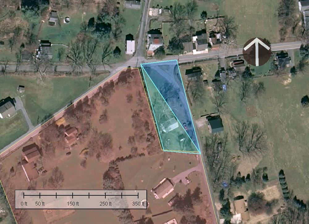
Oh, I finally found the recorded plan of the survey of the adjacent property complained of. Here's an overlay of that plan on a recent aerial with my best guess as to the actual ground location of the parcels subject of the OP shaded in turquoise blue.
At first impression, at least graphically, there is no major conflict. So it would appear that most of the conflict originates in some wildly mistaken ideas that the OP has possibly absorbed from someone somewhere.
Unfortunately, the attached plan of the survey of the adjacent property does not actually identify the boundary monuments found and set (as far as I can tell), so there is an open question as to how exactly the common boundary is marked, but my best estimate would be that the discrepancies that remain are on the level of a few feet at most, not tens of feet.
Kent McMillan, post: 444823, member: 3 wrote: Unfortunately, the attached plan of the survey of the adjacent property does not actually identify the boundary monuments found and set
No indeed. I'm not much impressed by that as a boundary resolution. The north line seems to follow the centerline of pavement and the south an existing "tree and stone row". But the east line varies from the road centerline by quite a bit and the west line varies from another "tree and stone row" by tens of feet. Yeah, it looks mighty iffy. That might be as good as it gets, but it's not something I'd just blindly follow.
Mark Mayer, post: 444825, member: 424 wrote: No indeed. I'm not much impressed by that as a boundary resolution. The north line seems to follow the centerline of pavement and the south an existing "tree and stone row". But the east line varies from the road centerline by quite a bit and the west line varies from another "tree and stone row" by tens of feet. Yeah, it looks mighty iffy. That might be as good as it gets, but it's not something I'd just blindly follow.
The most amazing thing about that plan is that the bearing basis is somewhere between 8 and 9 DEGREES off true. I'm guessing that it may have been based on magnetic North at the time of the survey, which would be very strange from a Texas perspective, if so.
Of course, it doesn't exactly build confidence to have the two bounding roads misidentified. Don't see that one very often, fortunately.
Last night, I didn't take the time to do as good a job of referencing the subdivision plat that adjoins the old Harmonyville School tracts as can be done this morning. The pinkish-shaded area should be pretty close to where the subdivision is on the ground based upon road pavements and utility poles shown on the plat.
I'm going to say that the original poster may well be ahead of the game to accept the line of the adjacent lot as platted as being the true West boundary of his land.


