

though this makes me laugh, reliably, any day of the week.


flyin solo, post: 424724, member: 8089 wrote: though this makes me laugh, reliably, any day of the week.
[SARCASM]Hey... at least it isn't to three decimal places![/SARCASM]

I get 14.923 acres, lol :rofl:
A Harris, post: 424731, member: 81 wrote: I get 14.923 acres, lol :rofl:
you forgot the å±
how many postage stamps fit in an acre +/-?
My favorite is the aerial mapping spec. (Marketing people don't get it):
"Flight altitude 20,000 ft (6096.012 m)"

flyin solo, post: 424724, member: 8089 wrote: this makes me laugh, reliably, any day of the week
Me, too! It kind of proves that even a halfway thorough understanding of practical mathematics is not really necessary in a surveying career.
Sergeant Schultz, post: 424941, member: 315 wrote: Me, too! It kind of proves that even a halfway thorough understanding of practical mathematics is not really necessary in a surveying career.
But it should be!
I have found that people that do not understand mathematics make terrible party chiefs and expect their computers to fix everything.
Sent one out with loads of information and existing control to find and take off and run a few miles and tie into other control.
He setup on an old hub and the other hub was a 1/4mi away and he backsited a monument 6ft away and took off, lol
A real genius.............
it's only thursday, but still...

at least his scale meets ALTA precision requirements.

Takes a mighty sharp eye to decide where 60.01 is as opposed to 60.02.
I think I have you beat 
ANOTHER_TEXAS_SURVEYOR, post: 426926, member: 8610 wrote: I think I have you beat
indeed. by this much. this = .5250 square feet.
flyin solo, post: 426799, member: 8089 wrote: it's only thursday, but still...
at least his scale meets ALTA precision requirements.
The North arrow is magnetic north - so who cares what the scale is. 😉
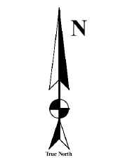
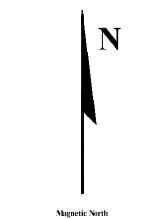
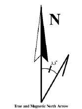
The style of north arrow used indicates if true north or magnetic north is indicated. The arrow on the left indicates true north by using a full barb. The middle arrow shows magnetic north using a half barb, and the third arrow indicates both directions and states the amount of declination. In general, it is best to indicate both directions.
erwsdot, post: 426956, member: 6038 wrote: The North arrow is magnetic north - so who cares what the scale is. 😉
The style of north arrow used indicates if true north or magnetic north is indicated. The arrow on the left indicates true north by using a full barb. The middle arrow shows magnetic north using a half barb, and the third arrow indicates both directions and states the amount of declination. In general, it is best to indicate both directions.
Now the great question regarding "what is 'true north'"....... and what is the proper arrow for "state-plane-grid north"?

I have a client that is reviewing my survey of a 1200'x1300' site lease. I am reporting the acreage as 35.81 and then he is checking my work by calculating the square footage at 1,560,000. Then he is converting my acreage to square feet and he only gets 1,559,883.6. He insists I am doing something wrong. I have been going round and round trying to explain it to him and I just can't help him to understand. This is desert land and we are only certifying to rural standards. If he wants me to certify to 35.812672 acres, he can't afford the survey.
Andy Nold, post: 426971, member: 7 wrote: I have a client that is reviewing my survey of a 1200'x1300' site lease. I am reporting the acreage as 35.81 and then he is checking my work by calculating the square footage at 1,560,000. Then he is converting my acreage to square feet and he only gets 1,559,883.6. He insists I am doing something wrong. I have been going round and round trying to explain it to him and I just can't help him to understand. This is desert land and we are only certifying to rural standards. If he wants me to certify to 35.812672 acres, he can't afford the survey.
been down that road a time or two. sorry. (the attorneys who execute 18 tons worth of documents with acreage that doesn't correspond to your measured value by like a thousandth or something...)
worst, though, is that same exercise with somebody who should know better.
i once quit a tech job because the RPLS contracted to review our work (cranking out r.o.w. parcels by the dozen) wouldn't approve a description unless it mathematically closed to some ridiculous precision- one that exceeded anything that any standard of practice dictated or that any CAD program could even possibly handle. eight places past the decimal or something. after crying to the powers that be for a while, and being told over and over again that the reviewer was to be satisfied, i just turned in my keys.
(best part has been running into said reviewer's actual work here and there in the years subsequent. which... he seemed to be a much more fastidious reviewer than a practicing surveyor.)
Andy Nold, post: 426971, member: 7 wrote: I have a client that is reviewing my survey of a 1200'x1300' site lease. I am reporting the acreage as 35.81 and then he is checking my work by calculating the square footage at 1,560,000. Then he is converting my acreage to square feet and he only gets 1,559,883.6. He insists I am doing something wrong. I have been going round and round trying to explain it to him and I just can't help him to understand. This is desert land and we are only certifying to rural standards. If he wants me to certify to 35.812672 acres, he can't afford the survey.
I like the idea of stating the acreage only on that large of parcel. If I must show square footage and acres, I prefer to state the square feet as the primary area and reference the acreage parenthetically. Hopefully they would check the acres by converting from the sf to acres. It's hard to explain significant digits to engineers and other non-surveyors. They just don't get it.
the software we use, and perhaps a lot of software, lets you tell it how far you want areas shown (ie: 0, 1, 2, 3....more places behind the decimal). The problem is that it does both square feet and acres to that same standard. It would be better to have it ask how many digits you want in the areas irrespective of where the decimal is. That way the square feet will be annotated close to the same precision as the acres. However, I would think the surveyor should edit his final product regardless (so he doesn't have sf to 2 or 3 places behind the decimal)