I'm in the process of trying to set a point within my community and bluebook it for quality control and also for other reasons. I have questions and need help from the great experts on this site. I appreciate anyone that can give me a hand. Email (scott at shieldssurvey.com) or call the numbers under my signature line.

For definitive and current information on the issue contact your NGS Regional Advisor Bill Stone. See above. For work in Colorado, Pamela Fromhertz is the contact.
The process entails developing a plan to meet your intended accuracy. Submit it for ore-approval. Make observations in accordance with the approved plan. In the case of projects observed with GPS you need to convert your processing results into the G-File format. You create descriptions/recovery notes for all points in the project. You create a series of adjustment parameter files (A-Files) for use with the NGS Adjustment software package (ADJUST). Perform a series of adjustments intended to provide optimal ellipsoidal coordinates and orthometric heights.
All the software and an invaluable document (Constrained Adjustment Guidelines) are available here: https://beta.ngs.noaa.gov/PC_PROD/ADJUST/
BTW, the software is only provided in DOS/Windows.
I can possibly provide help on specific questions posted to this thread.
HTH,
DMM
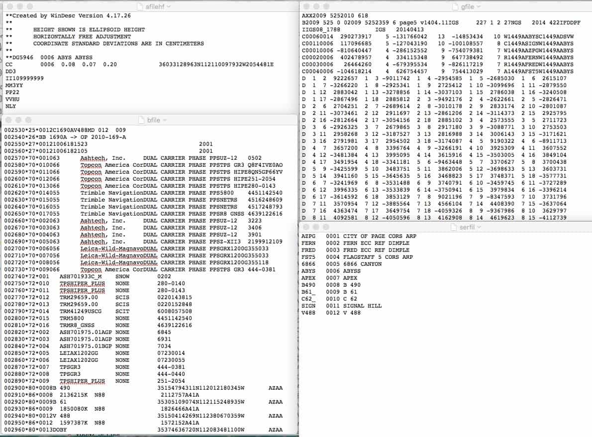
FWIW, I show above extracts from the files used in the adjustment portion of a submission to the NGS. They are all plain text files. Programs search for data in specific locations (columns).
1. The SERFIL is critical as it establishes the linkage between the input files for ADJUST. Its contents are the 4-character ID, a four-digit station serial number and the name of the associated point.
2. The "bfile" extract shows the elements of the file: *25*, *26* and *27* are "occupation records showing site occupied, date and time, receiver and antenna used and antenna height. The *70* and *72* records show receiver and antennas respectively that were used in the project. Note that each receiver and antenna are also assigned unique numbers. The *80* and *86* records are "a priori" positions and heights and codes for ALL monuments in the project. Obviously the known points can have published values.
3. The "afilehf" provides constraints and program instructions to the adjustment tool. The CC record contains the positions and heights and weighting information.
4. The "gfile" contains the GPS vector information including vector components, standard deviation for each component and the correlations between all baseline components. Some software packages do not provide the correlations.
NOT shown are the description file and output of checking programs.
The "Constrained Adjustment Guidelines" document mentioned previously has detailed information on the files and how adjustments are to be performed.
HTH,
DMM
Thanks DDM. I've found lots of info on the NGS site. Also I have talked to Mr. Stone. Just looking for someone to talk that has done this to help get this completed.
Get in touch with John Hamilton, he's done enough bluebooking to have developed custom software to smooth the process.
I've done enough of the bits and pieces of it to know that I want to avoid having to take a project all the way through from start to finish. It's pretty tedious and the time investment required to acquire the skillset isn't likely to pay off in the long run.
Have you considered OPUS Projects as an alternative? This was envisioned as a replacement for bluebooking as a means of sharing geodetic control reliably tied to the national spatial reference system.
I've learned enough about this process to know that I will never, ever, attempt it again.
Jim Frame, post: 418961, member: 10 wrote: Get in touch with John Hamilton, he's done enough bluebooking to have developed custom software to smooth the process.
I've done enough of the bits and pieces of it to know that I want to avoid having to take a project all the way through from start to finish. It's pretty tedious and the time investment required to acquire the skillset isn't likely to pay off in the long run.
Have you considered OPUS Projects as an alternative? This was envisioned as a replacement for bluebooking as a means of sharing geodetic control reliably tied to the national spatial reference system.
I've missed the deadline to take the class near me and my project has to be completed soon. Might have to punt and use opus. Still working on the details. Thanks for the reply.
Sent from my SM-G925V using Tapatalk


