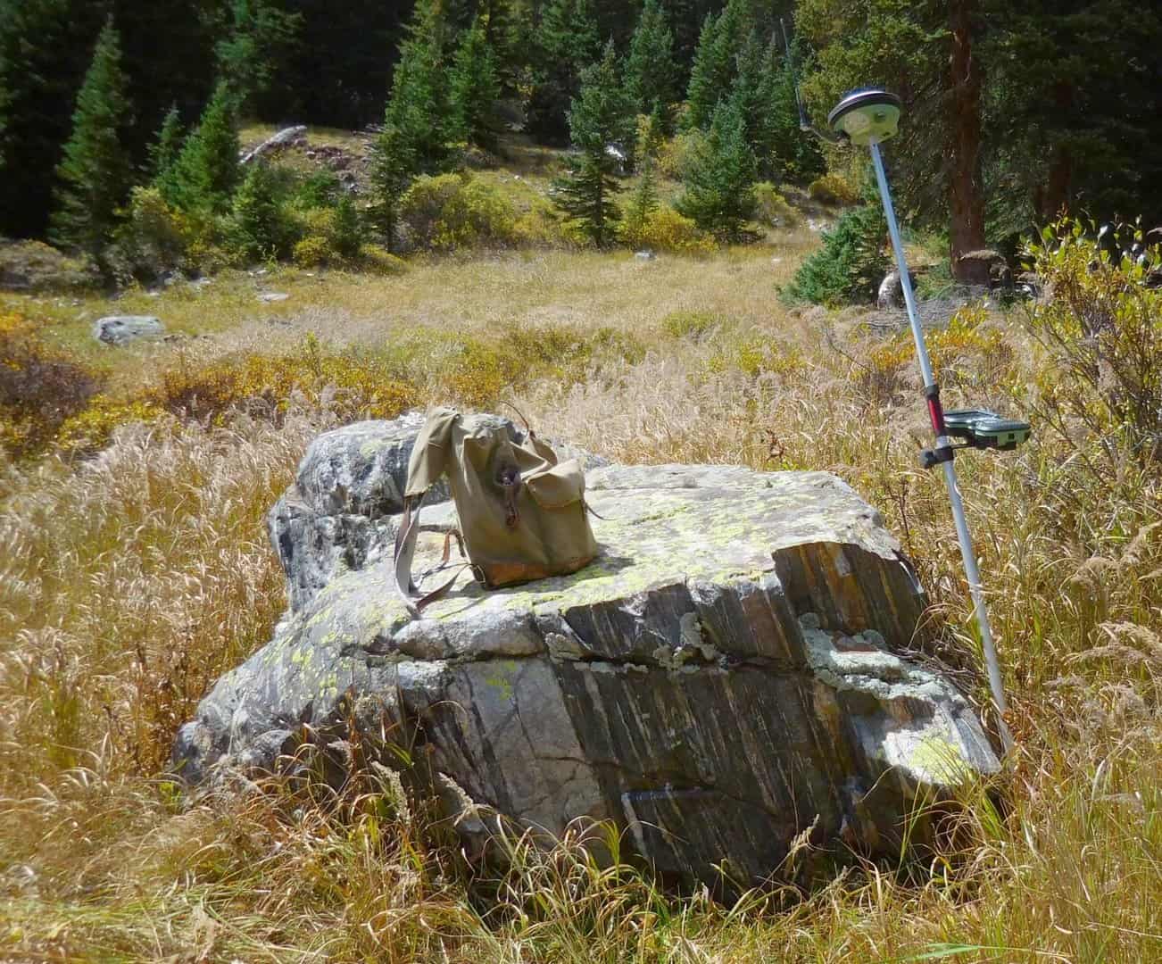
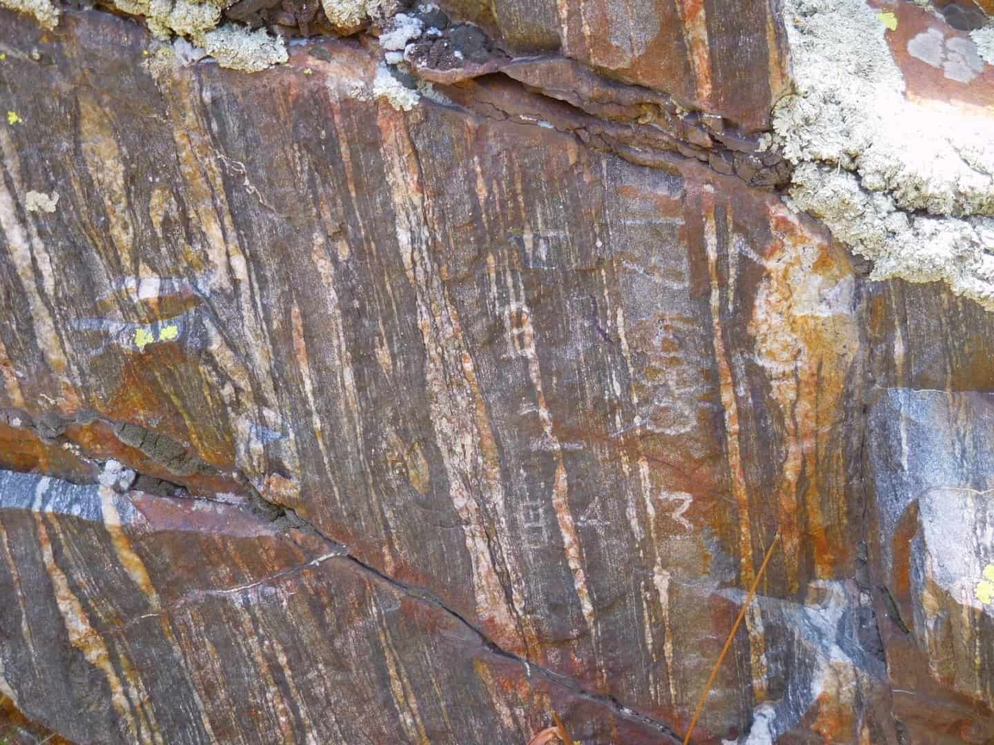
I had an opportunity to reoccupy the rock shown below to check its stability last month. In the midday sun and shadows it is very difficult to see the chiseled marks. The second photo shows some indications of the marks. I came back to pick up my Leica gear late in the day and the low angle sunlight lit up the chiseled marks from 1904 rather gneissly. I mention this because in another thread folks were discussing which compass they use. Being also a geologist, my choice is a Brunton International compass. One of its features that I find useful for surveying is the mirror. Instead of having to revisit a stone at different times in the day, reflecting the sun at different angles sure helps see faint chisel marks.
The last photo shows the chisel marks very distinctly except for the "7" in the mineral survey number "17480" that falls in a crack. The corner number ("3") and "B R" are very plain, but I'll let folks search for the chiseled "+" mark. The "S" between "B R" and "17480" is for the first letter of the associated lode claim's name.
The stone that this bearing rock is an accessory to is the stone I mentioned in the "Virtual Pin Cushions and Mineral Survey Retracements - A Colorado Tale" thread as Case 2 where a mineral surveyor in 1932 moved the stone 0.89 ft and rotated it 180å¡ before resetting it where he thought it belonged!
Better than a Gmean bearing rock 😉
I'm lichen it.
Wow...that's a gneiss one Gene!
😎
Loyal
On the subject of Mineral Survey accessories, we have yet to encounter a BO (Bearing Object) or BR (Bearing Rock) on any of the 3-4 dozen Mineral Surveys that we are currently retracing. Lots of BTs and BSs (Bearing Stumps), and a couple of BPs (Bearing Posts). This is only the second time I have encountered "Bearing Posts," and they were set in the 1880s by the same Mineral Surveyor who set some out in the Tintic District that I encountered a few years ago. Unlike those in the Tintic District, which are now in an open pit mine, there is a chance of maybe recovering some of these. Of course the rotted remains of the sub-surface base of the post is all we can hope to recover.
Loyal
Better than the schist I deal with all day.
:laughing:
Scott Zelenak, post: 393851, member: 327 wrote: Better than the schist I deal with all day.
:laughing:
We just take it for granite you're the best man for that job. 🙂
You guys rock!
Scott Zelenak, post: 393851, member: 327 wrote: Better than the schist I deal with all day.
:laughing:
Well, here's a tranquilized banded schist that I bagged on the same day. I've been monitoring its migration habits for the last several years.
A close-up of the tag information. Another bearing rock for the same survey, but for Cors. Nos. 2 of the Sunflower No. 1 and Sunflower No. 2 lodes. It also is a bearing rock for Cor. No. 2 of the Enterprise Lode (MS 8413).
I can do this all week guys! 😀
Those are beautiful Gene, and the tranquil setting is nice too.
Keep'em coming buddy.
Loyal
The first two bearing rocks in this thread are 630 ft. and 300 ft. down the hill from this bearing rock (same survey). No matter the sun angle, this one is very difficult to see the scribing. The light colored area to the lower right of the RTK antenna was carefully cleaned to remove the lichen cover. In Colorado, I've noticed that bright green colored lichen has an affinity for quartz. The rock type is a quartz rich pegmatite where the quartz crystals form a rough, pebbly surface.
The rough and uneven surface combined with the hard quartz crystals makes chiseling (and seeing) the marks very difficult. If you look closely at the lower portion of the "white" area in the close-up view you can make out a faint, but distinct "7". The "480" to the right of the seven are there but difficult to see. The position of the "1" to the left of the seven is a guess and golly.
If you look closely you might find some indications of the corner number, "3" and "B R", but the "+" is invisible. As for an "S" for the lode name initial, I never found one. The deputy may have omitted that because of the hardness of the stone.
That's a mighty big "rock" you got there Gene; where's the dimple? 😉
😎
RADAR, post: 394082, member: 413 wrote: That's a mighty big "rock" you got there Gene; where's the dimple? 😉
😎
Dimples are for desert-reptile woosies, RADAR! 😀
That rock has a very faint, but large "+" on it, trust me. Otherwise, you'll just have to come for a visit and see for yourself.
Dimples look good on rocks, and girls.... Just sayin!
Gene Kooper, post: 394039, member: 9850 wrote: The first two bearing rocks in this thread are 630 ft. and 300 ft. down the hill from this bearing rock (same survey). No matter the sun angle, this one is very difficult to see the scribing. The light colored area to the lower right of the RTK antenna was carefully cleaned to remove the lichen cover. In Colorado, I've noticed that bright green colored lichen has an affinity for quartz. The rock type is a quartz rich pegmatite where the quartz crystals form a rough, pebbly surface.
The rough and uneven surface combined with the hard quartz crystals makes chiseling (and seeing) the marks very difficult. If you look closely at the lower portion of the "white" area in the close-up view you can make out a faint, but distinct "7". The "480" to the right of the seven are there but difficult to see. The position of the "1" to the left of the seven is a guess and golly.
If you look closely you might find some indications of the corner number, "3" and "B R", but the "+" is invisible. As for an "S" for the lode name initial, I never found one. The deputy may have omitted that because of the hardness of the stone.
So besides piszing on these stones...
What else do you do to
Further identify them
In the field
Gene,
I am so fricking jealous!
We do a major happy dance IF we can find the rotted remains of a Bearing Tree/Stump or wood post in a mound of stone!
Aside from a FEW "readable" Bearing Trees/Stumps, we have to rely on the spatial relationship of the Mounds, rotted wood, Bug Dust, to identify the Original Monuments. I've been trying to remember EVER finding a Stone Mineral Survey Monument (or even the record of one) in Utah. Of course there is a LOT that I don't remember these days. At least in Nevada there are some Stone Mineral Survey Corners!
"4x4x4 hewn quacking aspen post set in ground" (no mention of a stone mound), is driving me nuts!
😡
Loyal
One last bearing rock (well, there is one more nearby but I won't post about it). This time the bearing rock is a quartz-biotite gneiss. Finding the marks on this bearing rock requires a practiced eye and some braille work to feel the marks.
This is the bearing rock to Cor. No. 4, MS 8411 surveyed on June 23, 1893. The original description is for a 5' x 3' granite boulder sticking 3 ft. out of the ground. Obviously, subsequent sedimentation has nearly buried the rock.
Robert Hill, post: 394175, member: 378 wrote: So besides piszing on these stones...
What else do you do to
Further identify them
In the field
Robert,
Since these are original accessories to a GLO approved survey, they can be used to reestablish obliterated corners. All five of the bearing rocks in this thread were set by the same mineral surveyor, Dep. W.H. Powless. I have found his work to be excellent. He used a solar attachment to determine the true meridian for his surveys and I have found approx. a 4 arc-minute difference between his bearings and my work. When I compare the bearing rock positions based on my static GPS observations, I differ no more than 0.24 ft. from the record information (accounts for the 4' bearing difference). The stones that these bearing rocks are accessories to are anywhere from 0.7 to 2.8 ft out of position from the record information; the stones being downhill from those record positions.
My GPS observations have found little to no movement over the last 10 years, so I do not have clear and convincing evidence that the discrepancies are definitely due to movement by soil creep and/or frost heave. It is just the most likely hypothesis to explain the conflicting evidence. I will hold the stones and add several notes to the plat explaining that the bearing rocks are superior to the stones for showing the positions, but that since I don't have direct evidence of movement, the "light-weight" stone monuments will be held over the "multi-ton" bearing rocks for purposes of showing the current boundary lines. The notes are mostly for the next surveyor to retrace these claims, which might be in 2096.
"The original description is for a 5' x 3' granite boulder sticking 3 ft. out of the ground. Obviously, subsequent sedimentation has nearly buried the rock."
Uh hum, FYI, all good surveyors pack a shovel everywhere they go. An hour or so of serious digging should prove the authenticity of the dimensions reported.;);):eek:


