No great recovery here since they were pretty obvious, but these points have been on my list to see. So, I took the day off yesterday to make the 3-hour journey to get some pictures. These points need to be protected, so I sense an upcoming project. There are also six intermediate points between the end points that need to be searched for some time.
Very nice. I am surprised that the condition of the stones are still so good. Would be interesting to compare the triangulation stations to some GPS observations.
Thanks for sharing.
that is very interesting, thanks,
Did the top one survive by design or just a fluke it didn't get trashed?
I see there's a plaque inside the bollards, but wondered which came first.
Is the plaque original or a later addition after a rediscovery?
I think these have survived by sheer luck. They need to be protected by their own iron fences. What you seen inside the fence is just a standard USC&GS tin marker sign.
That really needs to be GPS'd! I see that EAST BASE is a FBN, but not WEST BASE. Wow-an original intact baseline is present in Salina and MEADES RANCH (92 km NW) is also located in Kansas. Makes me proud to be from Kansas (born in Wichita)! These would definitely be worth protecting, just for historical interest. I have not yet made the geodesist's pilgrimage to Meades Ranch, but hope to do so someday before I die. These two would be on that list of things to see as well.
I have actually done some GPS work in Salina (Smoky Hill bombing range), wish I would have known about this I could have observed between the two ends of the base. The one thing I remember about going there is we departed in a US Airways flight from Kansas City, landed in Manhattan, and everyone else got off. I was the only one left on the flight to Salina. We arrived at Salina about 11:30 PM, and the car rental company had left the car for me in the portico of the terminal, keys in it.
Four things.
Funny how the grading bows around East Base. Lucky.
And only 4.07 miles long on the base? Seems like a shortie.
And great work AGAIN! I love seeing the old marks whose installation and measurement was so accurate and precise.
AND when can I help GPSing the crap outta that?!?!
Those short baselines probably seemed like a thousand miles to the crews measuring them with the bars. The bars were leapfrogged on tripods and read with microscopes. It would be a great seminar to protect them, GPS them, and search for the intermediate stones. The obstacle would be working with the railroad. East Base might be on private property.
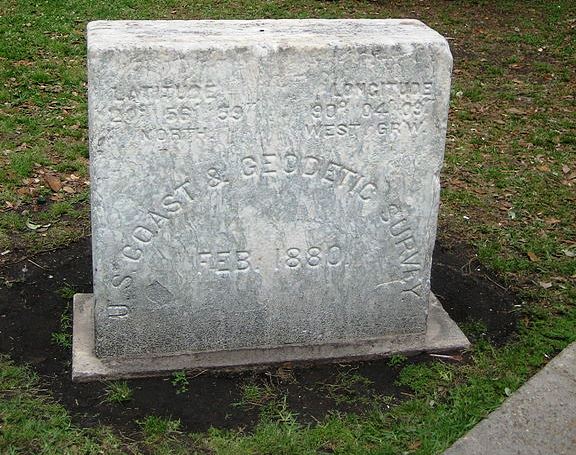
Here is the oldest USCGS marker that I have ever seen.
It is located in downtown New Orleans in Lafayette Square across from the Federal Courthouse and also adjacent to the original City Hall.
I believe it was part of the Tidal Survey done by USCGS in 1880
You can see the brass on on top,
these guys knew how to keep notes.they knew how to survey.
That is previous. I would like to a GPS baseline, direct measure between them. That would be interesting.
I also like that all of the descriptions in the the text are metric, with feet in parentheses.
In your writeup you say you "easily" recovered both monuments... the east one is certainly easy, but how did you find the west one? All the ties from the description were missing, I assume, and there was no magnetic material in the mark itself. There is a witness sign, but that doesn't really pinpoint it either. Did you just sort of randomly probe around the area of the sign?
There was a depression in the ground about the size I expected the monument to be opposite the "Survey Marker" sign, so figured that would be the place to start.


