Sometimes a lesson doesn't offer any answers or information, only questions. This is one of those lessons.
Somewhere in Cimarron County, Oklahoma, only about 6 miles east of the New Mexico State Line, sits a dusty little crossroads called Wheeless. Try as you may, there is little to no information to be found about this "less than exciting" patch of humanity. There ought to be a good story as to why or how it got its name. Can't find a thing.
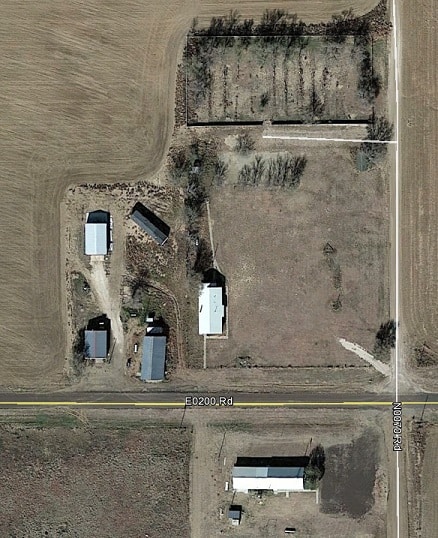
From an aerial, it doesn't look like much.
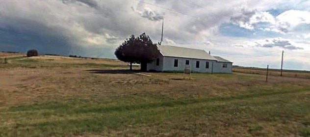
We do know there's a church, or at least USED to be a church. It may only be a community center nowadays.
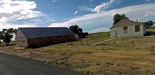
On t'nuther side of the road sits a few buildings that give me the idea it maybe use to be a school.
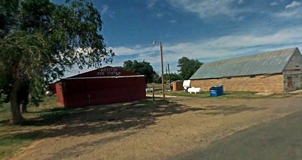
And at the west end of town sits the prominent, and at times necessary, Wheeless Fire Station:
The secret of existence at Wheeless may lie in what appears to be the cemetery on the north end of town, visible in the first pic.
Nobody knows and nobody's talking. Why Wheeless is there and how it got its name may indeed be lost to antiquity.
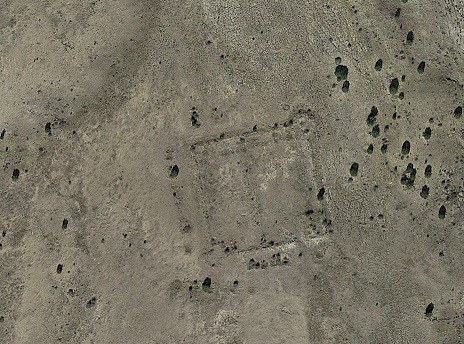
But there's ALWAYS something interesting....and Wheeless has its tourist's attraction. It's definitely not Meramec Caverns, and they don't have a 72 oz. steak for free if you eat it all in an hour. But about three and a half miles to the northwest of Wheeless sits the remains of Camp Nichols. It might have been named Fort Nichols if it had lasted longer than a few months.
Established by Kit Carson hisself, the camp housed U.S. Cavalry forces sent to protect the settlers and cattle drives on the Cimarron Cut-off of the Santa Fe Trail. At one time the fort was circumferented by a rock wall and housed a number of willing and able enlisted men. They were only there for a few months and then they were gone. Here is all that remains of the outpost nowadays.
And there is just about as much information available on Camp Nichols as there is for Wheeless; lost and forgotten in the corridors of Cimarron County, Oklahoma.
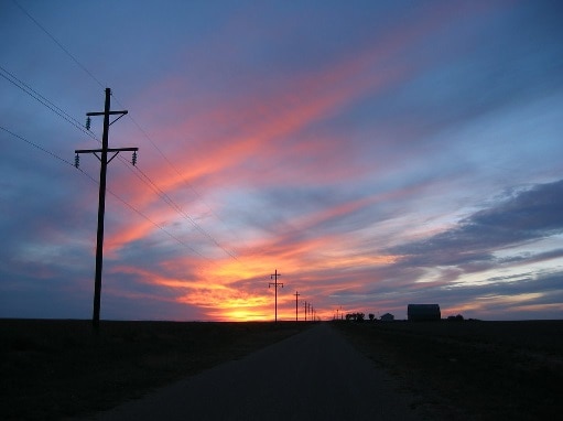
But maybe that's what "no man's land" (as they use to call the Panhandle of Oklahoma) is still really all about. It's about a land that is vast, hard and easily forgotten. But it is not without its beauty. Don't question the things that still exist there, don't long for the lost stories. Just enjoy the beauty of the wide open spaces that are still there, much like they were when the settler's first laid their eyes on it.
A unique beauty all its own.
One of the tricks to a good life is finding the beauty where ever you go. Some places it's easy, some places not so much.
Follow the link to read about Wheeless in the early days. Mr. Wheeless was the first postmaster so he named it for his family.
A search of the Wheeless Cemetery on Findagrave indicates it has been in use since at least 1908 with a burial in 2015. Some might want to call it Walkertown as 22 of the 131 burials have the surname Walker. There is one headstone there for a baby with the surname Wheeless but no other information.
For those unfamiliar with the uniqueness of the Oklahoma Panhandle it helps to understand that it only became eligible for legal settlement along with the creation of the State of Oklahoma in 1907. Six miles to the west of Wheeless is the eastern New Mexico state line. New Mexico didn't become a State until 1912. The Panhandle is 34 miles wide north and south but 166 miles long east and west consisting of Cimarron, Texas and Beaver Counties. Cimarron County is the only Oklahoma county along its northern state line that does not border Kansas.
The establishment of Camp Nichols by Kit Carson to protect travelers along the heavily traveled Cimarron Cut-Off of the Santa Fe Trail in 1865 predates the metropolis of Wheeless by 42 years. A community known as Mexhoma is located four miles to the west of Wheeless. (One burial in Wheeless Cemetery is someone named Mexhoma Kennedy.) About seven miles north of Wheeless was a community known as Mineral which existed prior to Wheeless. The infamous Robbers Roost of outlaw fame was near near Mineral and Kenton. Butch Cassidy and the Sundown Kid spent some time there on vacation, as did numerous other gangs including the Coe Gang.
Wheeless is equidistant from Boise City, county seat of Cimarron County, OK and Clayton, county seat of Unon County, NM. Felt, OK is 12 miles to the southeast and still has a high school producing about four graduates per year. Kenton, OK is 13 miles to the northwest and is famous for being the only spot in Oklahoma which officially runs on Mountain Time instead of Central Time. Seneca, NM is 14 miles to the southwest. This proves that Wheeless is the Hub of Activity. Also, about nine miles north of Wheeless is Lake Carl Etling, the only fishing spot for a VERY long distance (mentioned this lake in a post a day or two ago).
My grandfather and a collection of neighbors from west central Missouri headed to the new Oklahoma in 1907 to file homestead claims on quarter sections of land there. Thousands of others from all over the country did the same thing at the same time. So this block of land 34 miles by 166 miles with over 20,000 eligible quarter sections of "new" land sprang to life very quickly. Over 50 place names of "towns" were claimed in a very short time in Cimarron County alone. I have some post cards sent by my grandfather to my future grandmother back in Missouri that were mailed at Midwell, which ceased to exist. Nearly all of the homesteaders soon learned that rain was something they had forgotten to pack and bring with them to their new home as it was nearly non-existent. The soil is highly productive, but only when water is available to sustain life growth over the specific growing season of the plant desired.
Although a very high percentage of the homesteaders left the area upon completion of their five year requirement and many others were forced to abandon their dreams during the Dirty Thirties and Great Depression an amazing fraction of those homesteads are still owned by descendants today. Absentee ownership is more common than local ownership. Last year Ken Burns kicked out a great program about the Dust Bowl. A significant portion of the film kept returning to the diary of a woman who lived near Eva (Four Corners) and the center of the greatest concentration of the dust bowl events. This is near the midpoint (north to south) of the Panhandle directly to the south of the southwest corner of Kansas. That is maybe a dozen miles from my farm.
Norma Gene Butterbaugh Young and her parents owned the Boise City News newspaper for decades. She authored several books on the history of the area. The Tracks We Followed focused on the pioneer homesteaders. Not a Stop Light in the County and its sequel, Still Not a Stop Light in the County, provide great detail about the region, from Black Mesa, dinosaur tracks, Robbers Roost, Autograph Rock and The Santa Fe Trail to how things began, grew, died, found rebirth, died again, merged into something else, etc. One of the more fascinating general interest stories involves the accidental bombing of Boise City during World War II by a plane on a training mission.
Holy Cow, post: 325768, member: 50 wrote: .....One of the more fascinating general interest stories involves the accidental bombing of Boise City during World War II by a plane on a training mission.
BTW, I think the "bombing run" was actually flour sacks dropped from the plane.....
Thank you for filling in the gaps on the thriving metropolis of Wheeless, Mr. Cow. I'd have never known some of those tidbits if you hadn't spoke up. I worked the area extensively in the early nineties while at the highway department...and continued on with a few consulting contracts for county bridge work in the area after I quit my government job. That part of the world is truly a place all its own.
Funny story about the area: I was working on a county bridge topo south of Boise City (basically the exact center of nowhere) one warm August afternoon and blew a bottom radiator hose on our way back north to the blacktop. After everything cooled down I was able to cut the bad part off the hose and stretch it back on..in the hopes I could make it back to civilization. Trouble was we had very little water in the Covey and even though I had fixed the hose, I couldn't run the truck without refilling the radiator. I was scouting the horizon for a cattle trough with water when a local rancher roared by me. Despite my waving and darn near standing in the middle of the road, he kept going like he didn't see me. You have to understand that rancher that drove past may have been the only vehicle on that road for the entire week. My help and I walked a mile in each direction looking for some sort of water hole, but to no avail...and we would be loosing sunlight soon.
After about two hours I see dust coming in our direction. It was the same rancher that had blown past us hours earlier. He stopped and we chatted and he had 10 gallons of water in the back of his truck so we were saved. Although I was thankful for his help, I had to ask him why he passed us up earlier in the day. He calmly explained he had a doctor's appointment in Boise City he was headed to...and he knew we weren't goin' anywhere and would still be there on his way back. He was right.
Life has its own clock up there for sure. B-)
Ah... almost in my backyard. Grew up in Clayton. Done a few surveys in the area. Tough spot. Very few markers remaining. Some because only every other mile marked. The others buried many feet below the sand thanks to the dust bowl. But great history.
Might of used some of your crappy markers Paden. Just kidding about being crappy.
sent unknown location by me
Doesn't look like a flour sack to me!
http://www.travelok.com/listings/view.profile/id.677
This link about Boise City adds a bit on the bombing plus it points out what type of criminals have operated in Oklahoma since the early days.
Scotland, post: 325811, member: 559 wrote: Ah... almost in my backyard. Grew up in Clayton. Done a few surveys in the area. Tough spot. Very few markers remaining. Some because only every other mile marked. The others buried many feet below the sand thanks to the dust bowl. But great history.
Might of used some of your crappy markers Paden. Just kidding about being crappy.
sent unknown location by me
You're right about the depths. There was someone that did a good amount of surveying up there and left 1" sucker rod bars at the section corners, but the shallowest I ever found was a little over 3' deep. If you find one, the others will also be there. I've seen them run on for 15 miles or better, road or no road. I have no idea who set them. Most of the original notes call for pits and mounds or posts. BTW - Whoever it was blew past the 1/4 corners, never found one at a qtr. cor. ....and couldn't tell you how long they are...never dug one completely out of the ground!
You're right. I could've sworn I read they were flour sacks...must've been another Boise City....:pinch:
For Scotland
It's been some time but I've enjoyed fine dining at the Eklund Hotel in Clayton. The spooky part about eating there was all of the pictures and stories proudly displayed celebrating the hanging of Black Jack Ketchum. When the culprit grows fat in prison and the rope is too long............................well, let's just say that bad things can happen.
https://en.wikipedia.org/wiki/Tom_Ketchum
https://en.wikipedia.org/wiki/Eklund_Hotel
The casual driver knows they have entered the middle of nowhere when starting to leave Clayton headed towards Springer and discover a series of signs alerting drivers that not only is it 83 miles to Springer but................there ain't nothin' from here to there. No gas. No food. No nothing.
Lol. Paden. I've dug 6+ feet to find a buried fence. Rarely found anything else original. Some zinc pots if I'm lucky You are right about pits and mounds. Also common in SE Colorado.
Cow- very true. Like being in Montana. Eklund was good along with some other long gone restaurants. It reopened and actually was rebuilt to what it was waaayyy back. Blackjack was our famous gone-wrong hanging. Had a grave site at the cemetery.
I was told that part of Oklahoma aka "no-man's land" wasn't wanted by anyone. Texas, Kansas. .. finally the government forced Oklahoma to take. I like the small error on the PM and south state line.
sent unknown location by me
Another tidbit involving the Wheeless Cemetery.
I sincerely hope there aren't too many cemeteries with this combination of concerns.
The Boise City News
June 4, 2014 ·
Letter to the editor
There are two "No Hunting" signs at the Wheeless Cemetery. One on the gate and one on the south side of the cemetery property.
There are some hunters who, can't read but most likely choose to ignore the signs.
Empty shell boxes and shotgun shell casings have been found and a hunter seen sitting by the gate.
Those of us who have all our family and some life-long friends buried there, would appreciate it if you would respect the signs.
We are having enough trouble with the surrounding field covering up graves and monuments with sand.
If you are one of the hunters or one who owns blowing fields surrounding a cemetery PLEASE show some respect to our cemetery or any other cemetery.
We are getting some moisture now, make use of it!
Alma Jean Cryer
Scotland, post: 325842, member: 559 wrote: I was told that part of Oklahoma aka "no-man's land" wasn't wanted by anyone. Texas, Kansas. .. finally the government forced Oklahoma to take. I like the small error on the PM and south state line.
Texas would have been happy to hold on to the Oklahoma panhandle as part of its own panhandle as well as the rest of the land claimed by Texas all the way up to the source of the Rio Grande. However, admittance to the Union was more important and the fear of more war with Mexico led Texas to compromise by ceding claims to territory north of Latitude 36°30' - which you also might recognize as the division between slave and non-slave states.
paden cash, post: 325742, member: 20 wrote: Sometimes a lesson doesn't offer any answers or information, only questions. This is one of those lessons.
Somewhere in Cimarron County, Oklahoma, only about 6 miles east of the New Mexico State Line, sits a dusty little crossroads called Wheeless. Try as you may, there is little to no information to be found about this "less than exciting" patch of humanity. There ought to be a good story as to why or how it got its name. Can't find a thing.
From an aerial, it doesn't look like much.
We do know there's a church, or at least USED to be a church. It may only be a community center nowadays.
On t'nuther side of the road sits a few buildings that give me the idea it maybe use to be a school.
And at the west end of town sits the prominent, and at times necessary, Wheeless Fire Station:
The secret of existence at Wheeless may lie in what appears to be the cemetery on the north end of town, visible in the first pic.
Nobody knows and nobody's talking. Why Wheeless is there and how it got its name may indeed be lost to antiquity.
But there's ALWAYS something interesting....and Wheeless has its tourist's attraction. It's definitely not Meramec Caverns, and they don't have a 72 oz. steak for free if you eat it all in an hour. But about three and a half miles to the northwest of Wheeless sits the remains of Camp Nichols. It might have been named Fort Nichols if it had lasted longer than a few months.
Established by Kit Carson hisself, the camp housed U.S. Cavalry forces sent to protect the settlers and cattle drives on the Cimarron Cut-off of the Santa Fe Trail. At one time the fort was circumferented by a rock wall and housed a number of willing and able enlisted men. They were only there for a few months and then they were gone. Here is all that remains of the outpost nowadays.
And there is just about as much information available on Camp Nichols as there is for Wheeless; lost and forgotten in the corridors of Cimarron County, Oklahoma.
But maybe that's what "no man's land" (as they use to call the Panhandle of Oklahoma) is still really all about. It's about a land that is vast, hard and easily forgotten. But it is not without its beauty. Don't question the things that still exist there, don't long for the lost stories. Just enjoy the beauty of the wide open spaces that are still there, much like they were when the settler's first laid their eyes on it.
A unique beauty all its own.
It was formed by a bunch of Deadheads way back when. But they left........ ha. ha.B-)
