Hello guys,
I am doing a topographic survey along 10km road. the client asked to have a control point each 2km. that make in total 6 points. the road is a straight line south-west to north-east. I have 3 R8 receivers, what do you think would be the best way to measure these points?
to put one receiver at the beginning and one at the end and to travel with the third between the points? or to link between all the points like a chain, meaning to put one receiver at the first point and one at the second point and then to move the first receiver to the third point and go on.
another thing, should I trust the heights that I recieve from the network adjustment? or should I make levelling between all the points using a level.
knowing that the job is in an african country where there is no national geoid model and I will be using EGM96.
thanks in advance
I'd level rather than using a superseded gravity model.
I'd level even using EGM 2008.
I would shoot both ends with the GPS. Then hold one as control and level to the other end and back. You will see that levelling will be more precise than GPS values. Keep us informed of your work. Always interesting to see the results.
Sent from my SM-G925V using Tapatalk
The second method of traverse is quite common but the first one sounds good as well. You will have lots of redundancy if you use 3 receivers.
Levelling between the points would be worthwhile as well. Try to pick cool conditions to minimise refraction. I'm sure you know this already!
GPS both ends, hold one for vertical and level loop between them. Traverse between the two ends for horizontal.
Yazeed, post: 355935, member: 7947 wrote: Hello guys,
I am doing a topographic survey along 10km road. the client asked to have a control point each 2km. that make in total 6 points. the road is a straight line south-west to north-east. I have 3 R8 receivers, what do you think would be the best way to measure these points?
to put one receiver at the beginning and one at the end and to travel with the third between the points? or to link between all the points like a chain, meaning to put one receiver at the first point and one at the second point and then to move the first receiver to the third point and go on.
another thing, should I trust the heights that I recieve from the network adjustment? or should I make levelling between all the points using a level.
knowing that the job is in an african country where there is no national geoid model and I will be using EGM96.thanks in advance
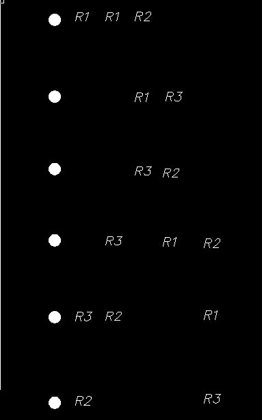
One possible plan for a static survey:
Each point should have at least two occupations, it's best to mix receivers and tribrachs.
In the US we have a bit of an advantage cause we are used to feet and meters, which will really help catch HI measure blunders in the field by measuring them in feet and meters.
Not sure what to do without a geoid model, that can be very messy, without a geoid I would certainly level the points, and then calibrate if GPS is going to be used to locate, , yuck, can't believe I'm saying that, you need a point "left" and "right" of the project to do it, calibrating along a straight line is dangerous.
My layout was done quickly, but I think you see the idea, redundancy is very important.
Thanks people that was very helpful
God bless America


