I'm lucky to have a couple of level runs over the mountain, the interesting result of using the geoid model and CORS values was that the "miss" on bench marks on the mountain was very close to the "miss" down on the plain. Same direction (high)
These aren't at 11,000+ Feet but there is a good 4000-5000' elevation change.
However they did it, they modeled the geoid shape rather well.
In some directions at some locations geoid heights are changing over .5'/mile so it can't be a simple thing to do accurately.
MightyMoe, post: 449047, member: 700 wrote: It has always been problematic to use CORS as a basis for elevations.
That is essentially what will happen in 2022 or thereabouts with the addition of a new geoid model. GNSS will be the basis of the new vertical datum and I would assume primarily using OPUS or at least the CORS.
SHG
Shelby H. Griggs PLS, post: 449079, member: 335 wrote: That is essentially what will happen in 2022 or thereabouts with the addition of a new geoid model. GNSS will be the basis of the new vertical datum and I would assume primarily using OPUS or at least the CORS.
SHG
It won't happen overnight, if it's anything like the last change 2045 might get it all done.
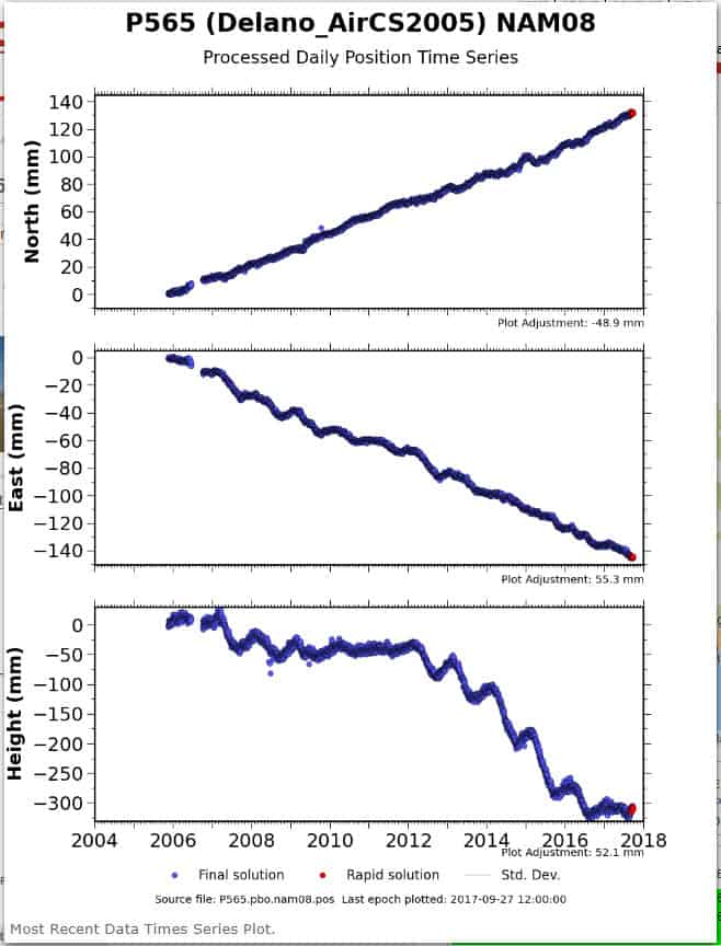
Here is the PBO times series for P565. The seasonal roller coaster would be hard enough to model, but the wildly changing vertical velocity (non-linear) would be almost impossible and would serve no purpose for looking into the future based on the past.
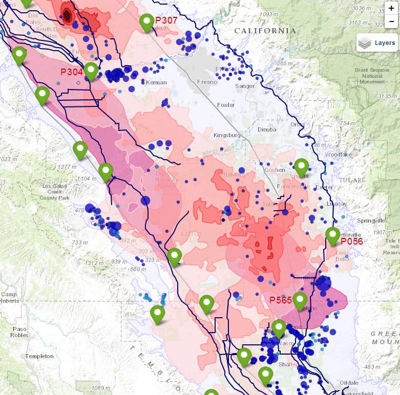
Here is a screen capture from the USGS San Joaquin Valley Drought Indicators site. As you can see, the subsidence has been severe and quite localized in some areas, so applying the logic that it is all sinking together isn't valid even over distances as short as a mile in some areas (El Nido Bowl in upper left).
Eppur si muove!
The NGS CORS long-term plots have not updated since 2012, they should refresh by early 2018 when NGS finishes reprocessing of all CORS data using IGS14 reference frame. This should also provide improved coordinates, velocities, and discontinuities (earthquakes and equipment changes). That reprocessing is reasonably automated (given the millions of files involved) until you get out west, where sites careen around like drunken sailors.
The NGS CORS short-term plots are generated from a special "net" version of OPUS which holds only the IGS frame as fixed. Normal OPUS obeys the National Spatial Reference Frame contention that all official coordinates are golden, though it does add HTDP to move things back and forth through time using the (from 2012-era) computed and modeled velocities. Many CORS were new back then and the velocities are relatively immature.
OPUS-S is now trained to solve from 5 nearby CORS and ignore the worst two solutions, so if only one CORS walks off from the official published position, OPUS should ignore it. For belt-and-suspenders, it also has an occasionally-updated blacklist of CORS to ignore, which includes these errant sites, mostly in California and Alaska.
The next reference frame won't be as beholden to these local motions, by design it takes off of ITRF with a simple clockwork-style Euler pole correction to remove all of the steady continental drift, and provides results at survey epoch (vs NSRS epoch 2010.0) Users can move points through time using an intra-frame velocity model (ala HTDP) to try to account for all of the localized variations, and the huge regional deformation out west where the Pacific plate drags California northward. This frame should be more honest and easier for to maintain, though it means that some local users will have to get used to their "control" drifting slightly over time. Eppur si muove indeed!
Joegeodesist, post: 450069, member: 6744 wrote: Eppur si muove!
The NGS CORS long-term plots have not updated since 2012, they should refresh by early 2018 when NGS finishes reprocessing of all CORS data using IGS14 reference frame. This should also provide improved coordinates, velocities, and discontinuities (earthquakes and equipment changes). That reprocessing is reasonably automated (given the millions of files involved) until you get out west, where sites careen around like drunken sailors.
The NGS CORS short-term plots are generated from a special "net" version of OPUS which holds only the IGS frame as fixed. Normal OPUS obeys the National Spatial Reference Frame contention that all official coordinates are golden, though it does add HTDP to move things back and forth through time using the (from 2012-era) computed and modeled velocities. Many CORS were new back then and the velocities are relatively immature.
OPUS-S is now trained to solve from 5 nearby CORS and ignore the worst two solutions, so if only one CORS walks off from the official published position, OPUS should ignore it. For belt-and-suspenders, it also has an occasionally-updated blacklist of CORS to ignore, which includes these errant sites, mostly in California and Alaska.
The next reference frame won't be as beholden to these local motions, by design it takes off of ITRF with a simple clockwork-style Euler pole correction to remove all of the steady continental drift, and provides results at survey epoch (vs NSRS epoch 2010.0) Users can move points through time using an intra-frame velocity model (ala HTDP) to try to account for all of the localized variations, and the huge regional deformation out west where the Pacific plate drags California northward. This frame should be more honest and easier for to maintain, though it means that some local users will have to get used to their "control" drifting slightly over time. Eppur si muove indeed!
Thanks Joe!
We are all (or most all of us) looking forward to the upcoming changes (both igs14 AND NATRF2022).
It might be a bit of a bumpy ride for some though (still time to check those shock absorbers).
😎
Loyal
Joegeodesist, post: 450069, member: 6744 wrote: OPUS-S is now trained to solve from 5 nearby CORS and ignore the worst two solutions, so if only one CORS walks off from the official published position, OPUS should ignore it.
When was this algorithm implemented? Might I get different results if I re-submitted a session from early this year?


