welcome to my world
That's the headline in a local news paper:
http://ensenada.net/noticias/nota.php?id=46585
translated https://translate.google.com/translate?tl=en-us&u=http%3A%2F%2Fensenada.net%2Fnoticias%2Fnota.php%3Fid%3D46585
not actually true. but not too bad for a newspaper
for some properties the tax guys have great difficulty creating their index maps (not many deeds have full mathematical geometry or a map attached), and much of others have just not bothered to go thru the full registration process.
enjoy
Which brings to mind that we don't have very many Mexican Surveyors on the board.
Probably stumble through a field of cash crops once or twice and become a liability to the local independent entrepreneurs.
Steve
sjc1989, post: 392702, member: 6718 wrote: Probably stumble through a field of cash crops once or twice and become a liability to the local independent entrepreneurs.
Steve
Funny... that is actually more common on the Northern coast of California.
I remember back in the late 80's or early 90's the Mexican government bought something like 650 Ashtech GPS receivers, and sent out an army of people to go all across the country and survey boundaries. The purpose was to give people title to their land, as title is required to use it as collateral for a bank loan to buy equipment, seed, fertilizer, etc. I remember reading a report on their work somewhere.
Here is one story about it:
http://www.heritage.org/research/reports/1992/10/bg914nbsp-salinas-prepares-mexican-agriculture
and another (page 14):
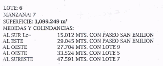
Peter Ehlert, post: 392703, member: 60 wrote: typical lot/block description. sub maps are not always easy to find
this deed also includes a survey plat
Medidas y Colindancias...learn something new every day! Thanks Peter.
Most of my surveying lingo en espanol at the paving company consisted of "dame cincuenta y cien". 😉
John Hamilton, post: 392706, member: 640 wrote: I remember back in the late 80's or early 90's the Mexican government bought something like 650 Ashtech GPS receivers, and sent out an army of people to go all across the country and survey boundaries. The purpose was to give people title to their land, as title is required to use it as collateral for a bank loan to buy equipment, seed, fertilizer, etc. I remember reading a report on their work somewhere.
Here is one story about it:
http://www.heritage.org/research/reports/1992/10/bg914nbsp-salinas-prepares-mexican-agriculture
and another (page 14):
thanks
that is about the Ejidos ( https://en.wikipedia.org/wiki/Ejido ) being formed as a result of the Agrarian Reform Act, kinda like homesteads... unoccupied federal lands are open for settlement. ( https://en.wikipedia.org/wiki/Land_reform_in_Mexico )
we have many nearby, one is rather new and it is quite aggressive, making wild claims. Kinda like stand on a hilltop, declare all open land as Ejido, then start the paperwork to create the Ejido, and eventually the possibility of conveying ownership to others.
paden cash, post: 392709, member: 20 wrote: Medidas y Colindancias...learn something new every day! Thanks Peter.
Most of my surveying lingo en espanol at the paving company consisted of "dame cincuenta y cien". 😉
Peter Ehlert, post: 392703, member: 60 wrote: typical lot/block description. sub maps are not always easy to find
this deed also includes a survey plat
here is the plat that is part of the deed documents, all on public record.
Peter Ehlert, post: 392713, member: 60 wrote: here is the plat that is part of the deed documents, all on public record.
I have lived in Monterrey in the past, and my oldest daughter has lived there for about 8 years now, and all of my wife's family lives there as well.
I saw a notice in the local paper there about the boundaries of a newly acquired tract in a national forest outside of the city. It was all described by UTM coordinates.
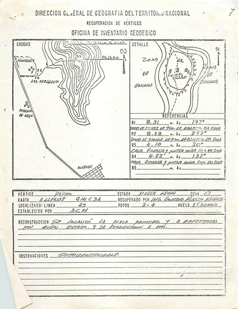
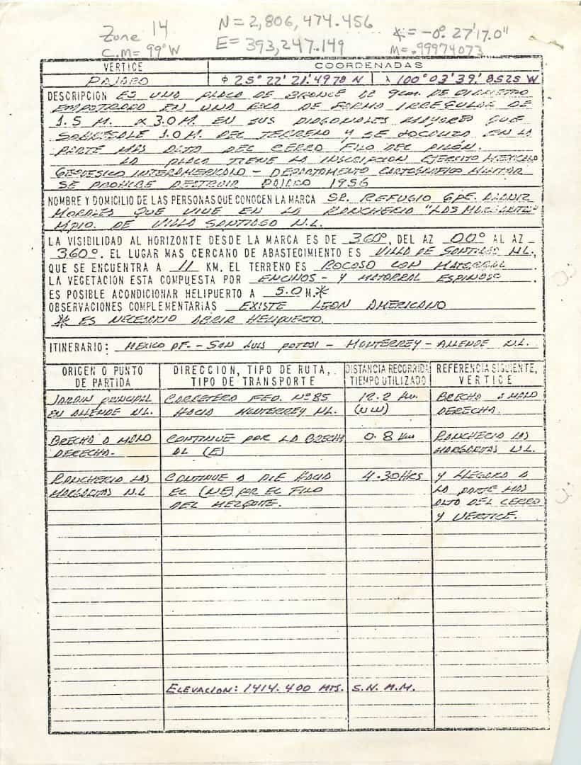
Funny story about when I lived there, which was in the early 80's. I wanted to go and recover some triangulation stations (just for fun). I had all of the 1:50K quad maps for the state of Nuevo Leon. So, I picked out a couple of stations, and went to the local INEGI office. INEGI is sort of a combination USGS/NGS/Census Bureau. Anyway, I showed the clerk the triangulation stations on the map, and said I wanted recovery sheets with coordinates. They were confused, and they starting calling different people over to help me, and somehow the "coordinates" part got emphasized. So finally, a guy came out with a scale and was going to scale the coordinates off of the map for me. Duh, I could have done that. Finally I got the right person and got some descriptions.
Here is one of the recovery sheets (the UTM in pencil at the top of page two is my comps). Note the interesting item about the middle of page 2, under "observaciones complementarios". It says "existe leon americano", which basically translates to "mountain (american) lions exist in area"
I found in my files an article in El Norte (Monterrey newspaper) dated March 8, 1993 where they tell about the ejido project (in spanish, of course). The headline is "They will measure ejidos"
This is a cool thread. Thanks Peter, John ,et al.


