

Ask A Surveyor
Public Group
Public Group
Active a week ago
If you are a landowner seeking advice from surveyors, please post your questions and issues here.... View more
Public Group
Organizer:
- Organized by
-
Group Description
If you are a landowner seeking advice from surveyors, please post your questions and issues here. DISCLAIMER: All surveying-related questions should be consulted with someone licensed in their jurisdiction and hired for professional services. The answers provided here are not to be construed as official advice from a professional that you would otherwise obtain in your local area.
“plot plan” versus “boundary survey”
“plot plan” versus “boundary survey”
duane-frymire replied 1 year, 2 months ago 28 Members · 59 Replies

The problem is the “plot plan” is considered a bona fide survey by the unsuspecting public.
Generally these were created by and for lending, due to federal requirements to lower closing costs to make homes more affordable to lower income folks 1980’/90’s. They certainly were not going to lower their own take, nor that of attorneys. The mortgage survey had to go. Likewise the attorneys opinion of title, but they simply formed title companies. My last mortgage I had to sign an acknowledgement that I was informed of common ownership interest of attorney, lender, and title insurance company. Then signed an owners affidavit that nothing had changed from a 15 year old survey. Anything to get those closing costs down (a worthy goal no doubt).
So instead of an Attorneys title opinion and a “bona fide” survey, the lender now gets a title insurance policy on every property which allows a lower cost (used to be only on major dollar properties). And these policies except anything a survey would disclose, but they will remove that exception with an inspection that they call “plot plan”.
The title policy and Plot Plan are required and in the name of the lender. But, the consumer pays as part of requirement for the loan.
Hence, many consumers think they have purchased a bona fide survey for themselves, when in reality they have not purchased a bona fide survey and it was not for themselves. And they have not purchased title insurance for themselves, only purchased it for the lender.
The reason the lender/title insurance will remove the survey exception is due to actuarial studies that showed very little risk of loss if a quick inspection was done. This quick inspection in most urban/suburban areas should be enough in most cases to determine if there are any major encroachments.
As can be seen in this thread there are other uses of the term plot plan. A consumer can use one to obtain a permit but is still liable if end up violating code.
A “bona fide” survey is an actual “professional opinion” of the precise location of the parcel lines. It’s not a guarantee either, but it’s a much higher level of risk management than the “product” of a “plot plan”.
I like the route of describing an ILC some States have taken. Would be nice to have a national definition of ILC, and something for proposed plans not based on a “bona fide” survey, but “plot plan” is used in so many ways in so many differing laws/agencies that it would be impossible at this point to use that term.

Sorry, you’re right. I should have said “proposed offsets”. I’m just used to saying I’m “checking the setbacks”.

I’m curious what everyone else’s definition of a “plot plan” or “site plan” is and what kind of note would you put on a “site plan” if you just wanted to show the boundary lines without doing a whole survey?

I’m curious what everyone else’s definition of a “plot plan” or “site plan” is and what kind of note would you put on a “site plan” if you just wanted to show the boundary lines without doing a whole survey?
I consider a site plan to be topo, utilities, boundary, show all easements, encumbrances, ect. A plot plan is a layout of proposed structures.
Often a pilgrim says they want an ALTA when all they need is a site plan. Site plan pre design, plot plan post design.

this ain’t no plot plan for sho.


I believe the plot plan is intended for the rough grading of the lot at the critical locations like at the Right of Way, setbacks, corners and drainage swales. In addition, utility services and drive approaches are shown to help the local jurisdictions review the design intent and facilitate inspections.
A boundary survey should be performed to establish the property lines and right of way which in turn establishes the setbacks and ultimately the building location. Ideally the boundary survey is the foundation from which the plot plan is developed.

This is a good example of the importance of understanding scope of work for either the client or the surveyor. Here in OR, plot plans are referred as site plans. We commonly receive site plans from architects and engineers prior to a topographic surveys. I don’t know why anyone couldn’t create one based on tax assessment maps, zoning code, and “planned” development. If a surveyor prepares one, there should be an understanding from the client to what accuracy or reliability the boundary will be depicted. A boundary survey is far different than a site plan, though a site plan will depict a boundary, for the intent of the plan. I’d like to know the back story behind the OP because it sounds like an odd question.

@wagner152
(KT_88)

Now…


Eh, I’ve called something a plot plan, but it was the result of a boundary survey, and looked the part of a boundary survey, just wasn’t going to be recorded.
I don’t know if plot plan is legally defined as being something other than a boundary survey. It may be getting mixed up with mortgage survey or mortgage inspection plan

Words mean things. You call it a “plot plan” (or similar) to distinguish it from a survey.
In my opinion “plot plan” is a colloquialism. If I receive a request for a “plot plan” I need an explanation for the purpose, what is being done, and who is making the requirement. There is a huge variation in the meaning and purpose.
In the definition of surveying terms one may find the meaning of plot, and the meaning of plan. There is no definition of “plot plan” so in my mind it is not a thing. All plans are plotted.
Once I have understood the purpose of any project I can make survey measurement accordingly. However the only measurements to be made with a tape are missing dimensions of a building that could not be observed with the survey instrument. No surveying can be performed with only a tape if you are adhering to the standards of practice.
Historic Boundaries and Conservation EffortsIn the definition of surveying terms one may find the meaning of plot, and the meaning of plan. There is no definition of “plot plan” so in my mind it is not a thing. All plans are plotted.
I’ve always understood a “plot plan” as a “plan” for a “plot” of land. Maybe could also be called a “lot plan”? Generally I just call everything a “site plan” though. However, back to the point, my dilemma is if all I need is to show the boundary relative to the project and I am nowhere close to the setbacks, then why do a full blown survey? Just a couple corners to tie into would be close enough I would think and keep costs down for the client.

In my New Jersey experience, a “Plot Plan” is something that relates to new home construction with the boundary being based on a recent survey and I’m not aware of any place in this country that a PLS or RLS can propose the location of a new structure as grading, drainage and other issues come into play. A Plot Plan is the responsibility of a PE to prepare with reference to our suryey plans.

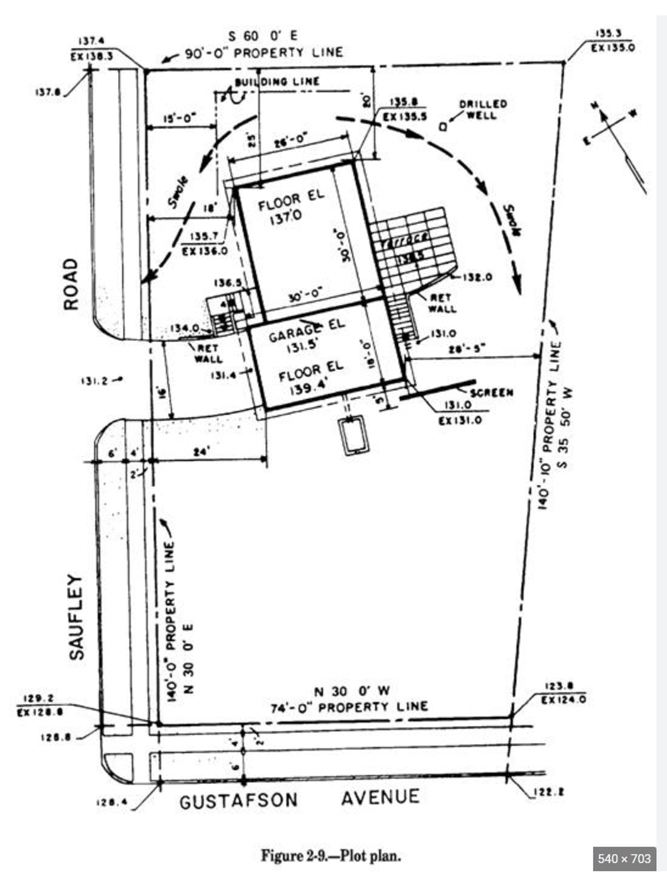
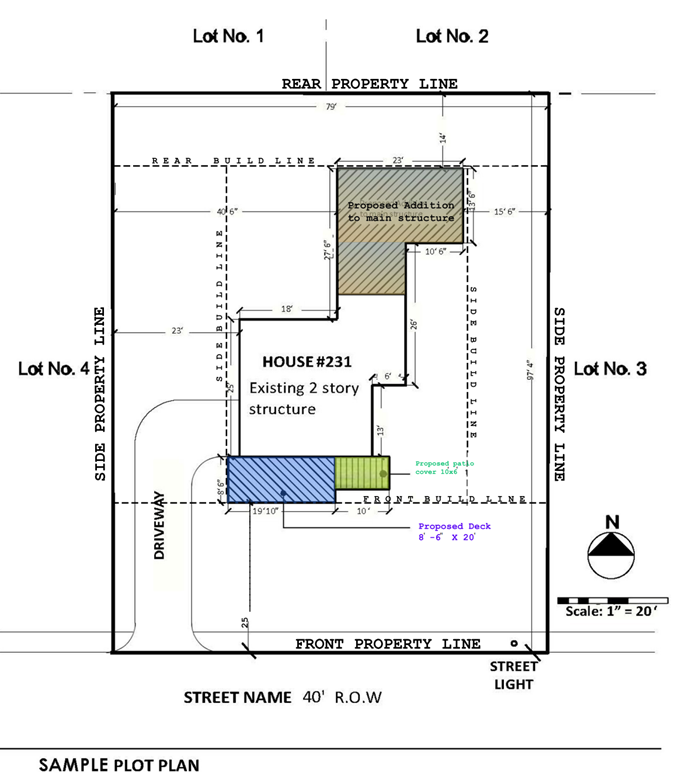
Two images found online… one with detailed measurements and bearings, the other not.
Both called plot plans?
@r-leonard
My experience with plot plans would be more similar to the bottom one but usually with more information regarding grading, sanitary etc.
Same here, and most of our plot plans come from a local engineering company.

plan = to be
survey = existing

I’m not aware of any place in this country that a PLS or RLS can propose the location of a new structure as grading, drainage and other issues come into play.
Maryland Statutes
Article – Business Occupations and Professions
§15–101. (2) “Practice land surveying” includes:
(iii) platting, layout, and preparation of surveys, plats, plans, and drawings, including:
1. site plans;
(vi) in conjunction with the site development or subdivision of land, the preparation and design of plans for the following projects, provided that such preparation and design are in accordance with design manuals, details, and standards accepted by the State or local authority:
1. road and street grades;
2. sediment and erosion control measures;
3. nonpressurized closed storm drainage and stormwater management systems; and
4. open conduit storm drainage and stormwater management systems.Delaware Code
(5) “Practice of land surveying” shall mean professional services or work involving special knowledge and application of the principles of mathematics and related sciences and the relevant requirement of law in connection with the use and development of land, as described herein:
c. The design, preparation and furnishing of subdivision plans, land development plans, sedimentation and erosion control plans, grading plans, condominium plans, record plats and horizontal alignments, and profiles and typical sections for roads, streets, utilities, sanitary sewers and storm drainage systems. This shall not be construed so as to permit the professional land surveyor to include the design of sewage disposal stations, lift stations, commercial and industrial buildings, pumping stations and bridges, or to prepare plans for the construction of engineering and architectural projects.
Code of Virginia
The “practice of land surveying” includes surveying of areas for a determination or correction, a description, the establishment or reestablishment of internal and external land boundaries, or the determination of topography, contours or location of physical improvements, and also includes the planning of land and subdivisions thereof. The term “planning of land and subdivisions thereof” shall include, but not be limited to, the preparation of incidental plans and profiles for roads, streets and sidewalks, grading, drainage on the surface, culverts and erosion control measures, with reference to existing state or local standards.
Pennsylvania Registration Law
“Professional Land Surveyor” means an individual licensed and registered under the laws of this Commonwealth to engage in the practice of land surveying. A professional land surveyor may perform engineering land surveys but may not practice any other branch of engineering.
“Engineering Land Surveys” means surveys for:
(i) the development of any tract of land including the incidental design of related improvements, such as line and grade extension of roads, sewers and grading but not requiring independent engineering judgment…(iv) storm water management surveys and sedimentation and erosion control surveys;
(v) the determination of the quantities of materials;
(vi) tests for water percolation in soils; and
(vii) the preparation of plans and specifications and estimates of proposed work and attendant costs asdescribed in this subsection.@james-fleming And SC and MN and some others I can’t recall.


Log in to reply.