
saw a couple scruffy mule deer and a young cow elk...
Thanks for the reminder....
....
ran a short session for OPUS RS while I searched for some other BM's- since I didn't have time for a full session. I'll check it out but I don't think I can get a passing solutions for the OPUS Share due to the large conifer due east of the mark...
ww447

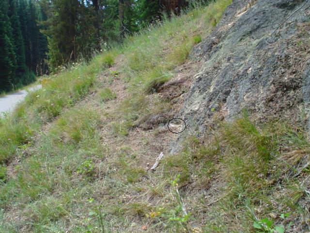
It would have made better sense had they put the monument on top of that boulder than near the bottom.
12+ ft and you would have been in the clear........ ?
It would have made better sense had they put the monument on top of that boulder than near the bottom.
12+ ft and you would have been in the clear........ ?
That's what I was thinking. Not being a surveyor, is there something obvious I'm missing here?
I don't think they were contemplating multipath when they were setting benchmarks across the Bitterroots in 1945...
Even so, what about all around visibility, room to swing a cat, etc. Was (is) it a BM just for elevation?

I suppose you've figured out the thread title is wrong and it's UU 477.
https://www.ngs.noaa.gov/cgi-bin/ds_mark.prl?PidBox=QZ0027
Here's an older (stolen) picture of the location
?ÿ
?ÿ
Well, there you go, that photo and the NGS report explains everything, although a foot seems to be missing.
QZ0027'DESCRIBED BY US GEOLOGICAL SURVEY 1964
 QZ0027'23.0 MI SW FROM CONNER.
 QZ0027'23.0 MILES SOUTHWEST ALONG THE CONNER-GRANGEVILLE ROAD FROM THE POST
 QZ0027'OFFICE AT CONNER, RAVALLI COUNTY, 0.8 MILE SOUTHWEST OF A POINT CALLED
 QZ0027'PEYTON ROCK, 277 FEET NORTHEAST OF THE NORTHEAST END OF A BRIDGE OVER
 QZ0027'SHEEPHEAD CREEK, 44 FEET NORTHWEST OF THE CENTERLINE OF THE ROAD, IN
 QZ0027'THE BASE OF A LARGE PROMINENT ROCK POINT PROJECTING 1 FOOT ABOVE THE
 QZ0027'GROUND, AND ABOUT 8 FEET ABOVE THE ROAD.
The original picture is deceptive.?ÿ Looking into the face of the hill, to me it?ÿappears as though the antenna is nearly touching the rock face.?ÿ Bill's picture of the slope profile makes it make a lot more sense in general.?ÿ At first I couldn't understand?ÿwhy you were worried about the trees and not the rock LOL.?ÿ ?ÿ
Dang I had 447 on the brain last night-