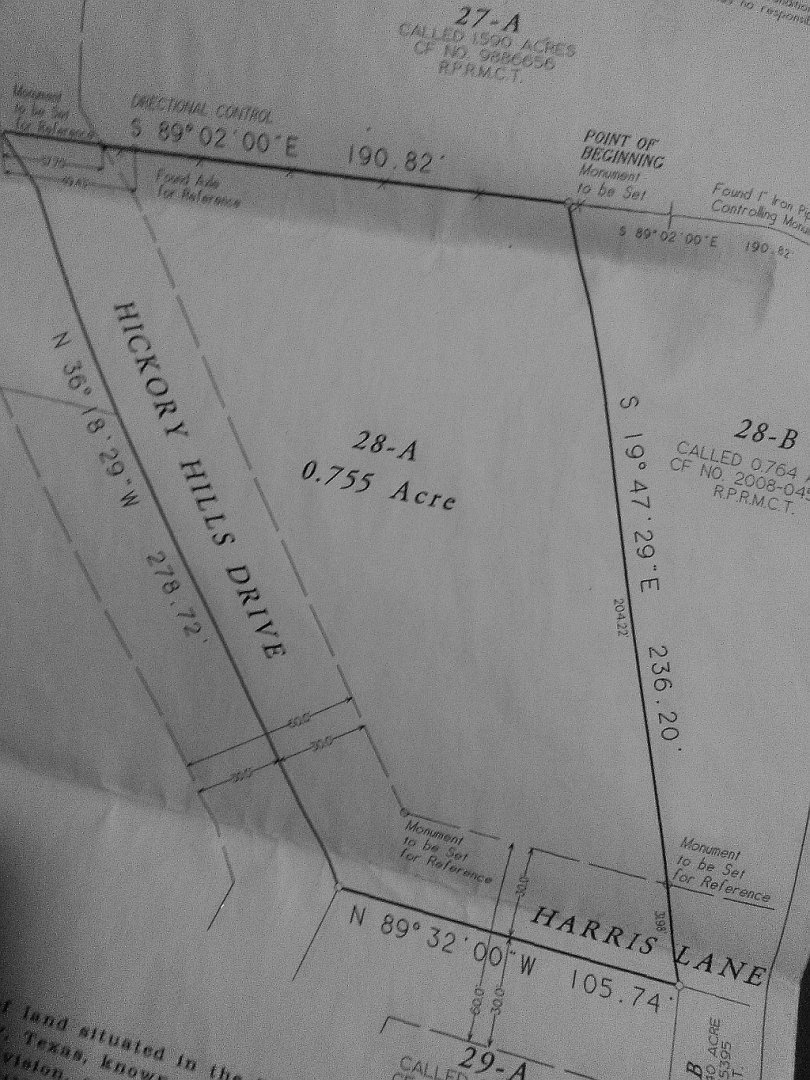
As is often the case and stated over and over.. "it depends". Having encountered this kind of mess on many surveys, sometimes it is more time effective and gives me a sense of comfort is to reconstruct lines from the rear and adjoiners descriptions and any monuments I can find. Often the local jurisdiction can be of help too for any historical information, especially road departments.
The road is where it is. We just show it on the map. Sometimes I've fixed this kind of mess with some re-platting and property line adjustments if all parties can agree. Then it stays out of court and saves everybody money.
The last time he logged in was,
Sunday at 7:09 PM
I myself like playing with these puzzles. It's like my game was taken away. :-S
OK. Problem solved. The owner of the company came out and checked my claim, the physical markers did not match description and the team that did the original work had been let go over a year ago
That's ok, I guess. But you've teased us. I for one would like to see the deed, and the survey you have in hand. For one it entertains me. And it gives me something to continue my Professional studies of what went wrong here.
Oh I do pray your problem is rectified. We as Professional Surveyors see these blundered situations almost daily. So there is nothing new about this. But each situation is unique. So if you would supply the data on hand, and then update as things move along.
Don't leave us hanging!
Can't post pic cause file to large... Using phone. Email me and I'll send a reply with photo maybe u can upload it
The deed and survey match all but the roadway allotment.
Sent. What was marked as an old axle was actually a cyclone fence post cut off and beat flat
What the heck? "Monument to be set"?
Must be a common practice in Texas.:-$
LOL! 😀
Dave Karoly, post: 344046, member: 94 wrote: What the heck? "Monument to be set"?
David, you should know, delayed monumentation is very common in California, the Sub Map Act provides for it, usually followed with a certificate of correction after construction. could be the same case here, maybe.
bottom line: if we don't know what was set, if anything, we don't know much of anything.
(that looks like the original sub map, not a map created for this transfer, hard to see)
"Monument to be set" does not fly in Texas without the official "PRELIMINARY" quote stamped on the paperwork to indicate that the project is not finished.
:gammon:
"Monument to be set" are the stakes they placed in wrong place and again.. The " Axel" they found turned out to be part of an old fence
IMVHO, the paperwork was handed out before they went back to set the monuments.
A single miskeyed stroke on a data collector will give an object the wrong identity.
You should address most of your questions to that surveyor that signed the certification and ask for updated paperwork that shows the completed survey you paid for.
It's called "post-monumentation" in Oregon.
If there is a signature and seal on that drawing and the surveyor of record has not set monuments of a "permanent nature, etc.", the surveyor has committed an infraction of the laws of the State of Texas. There was (and it may still be ongoing) a thread about this very topic last weekend.
The TBPLS is very thorough and prosecutorial (maybe not a word that can be made into an adverb) about complaints of this nature which are submitted to it.


