Part 3 (Because of length restrictions, Secs. 10-226 through 10-228 are included in Part 2 of page 1 of this thread)
The last section under the topic of ??Gaps and Overlaps? Not of Record is Sec. 10-229. The first paragraph restates the second sentence in 10-228 that for mining claims, ??described and surveyed as contiguous, the intent of the Federal Government is neither to retain unmanageable slivers of land nor to convey land described in a senior grant or conveyance.?
The remaining two paragraphs describe conditions similar to how closing corners were and are dealt with in rectangular PLSS surveys. Closing corners were set on existing lines without benefit of retracement for surveys conducted under instructions issued before the 1919 Advance Sheets.
Sec. 10-229; second paragraph
By policy no longer in effect, monuments were set on existing lines without benefit of retracement. The reported intersection point was tied to only one corner of the existing line. In these cases where the monument is found to be not at the record position, the monument should determine the direction of the line but not its legal terminus. The true position is at the point determined by extending or terminating the line to intersect with the fixed line (see section 7-45 for survey and monumentation procedures).
From my research, the first sentence of the second paragraph of Sec. 10-229 does not apply to mineral surveys. The first set of mineral survey instructions I found to explicitly require a retracement of the senior line was the 1883 instructions for the District of Colorado. Prior to that, the 1873, 1878 and 1880 instructions for Colorado only state that the conflict shall be shown and a tie made to a corner of the senior claim(s). The mineral surveyor was instructed to prepare his field notes in the form showing a connection to only one of the corners, but that did not mean that he was not required to retrace the line(s) of the senior claim(s) in conflict with the survey he was conducting. In cases where only one or no senior claim corners were found the senior claim was shown at its record position. Beginning with the 1886 instructions to mineral surveyors for the District of Colorado the deputy was required to state in a separate letter report any material errors with prior official surveys. The requirement that any material errors in prior official surveys be reported meant that a full retracement of all lines of senior claims in conflict with the survey was required by 1886.
I applaud that the Manual includes situations where junior intermediate corners that call to a senior line should be regarded as closing corners. However, in my opinion for cases where there is a technical gap the resurveyor should regard the junior corners as witnessing the senior line, but not necessarily marking the senior line. In other words, if the junior survey makes a call to a senior line, the monuments marking that senior line are also monuments of the junior survey. As such, they are to be included in the originally established monuments that define what ground has been patented as described in the Act of April 28, 1904 and, therefore are closing corners. I will post an example of a junior claim with intermediate corners that has a technical overlap with a senior claim along with my reasoning that the BLM is without jurisdiction to bend the senior line through the junior corners.
A possible fix for a common situation not covered in Chapter X of the 2009 Manual.
There are many instances where junior corners were purposely set on the theoretical interpretation of the senior line rather than the true line as monumented on the ground. I found an IBLA case that indicates a method to correct errors in patents that may be applicable to situations where the junior corners were set on the theoretical position of the senior line. The following is extracted from the head notes of IBLA case "Beau Hickory and Patricia L. Tinnell?:
"Under section 316 of the Federal Land Policy and Management Act of 1976, 43 U.S.C. (Paragraph) 1746 (2000), the Secretary has the authority to correct errors in patents and conveyance documents where an error in fact requires correction and considerations of equity and justice favor such correction."
It may be a method for a patentee to correct an erroneously monumented boundary. My wonder is whether the benefits outweigh the costs of going through the process.
While as a private surveyor I am not legally bound to the instructions on resurveying mineral lands in Chapter X of the 2009 Manual, I am required by Colorado statutes and Board Rules to employ the manual as a guide for my work. I am also aware that the BLM is delegated the authority to determine the boundaries of Federal interest lands. Should I decide to vary from the Manual, I??d best have a damned good reason.
I'll post some examples next for those who made it this far! 🙂
This is all really good 'stuff' Gene, keep up the good work.
Loyal
Example 1 - Junior Claim Overlaps Senior Claim.
For the purpose of the following examples, the conditions described in Section 10-225 of the Manual are assumed to be met; that being:
When the relationship between the monuments is substantially as approved, and there is no evidence of fraud, mistake, or gross error, the line running though the intermediate monument, as measured, will be returned as common to the claims.
When determining whether the conditions found during the retracement are substantially as approved, the surveyor shall be guided by law, rules, official policy, effect on extralateral rights, and survey principles thereof.
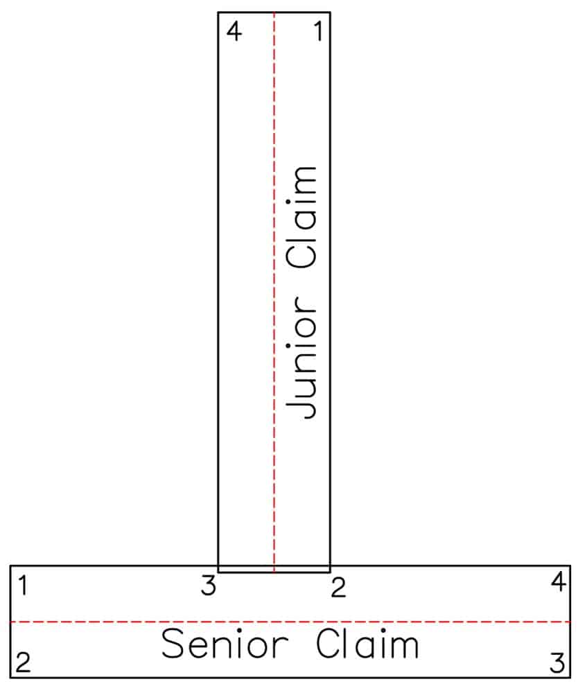
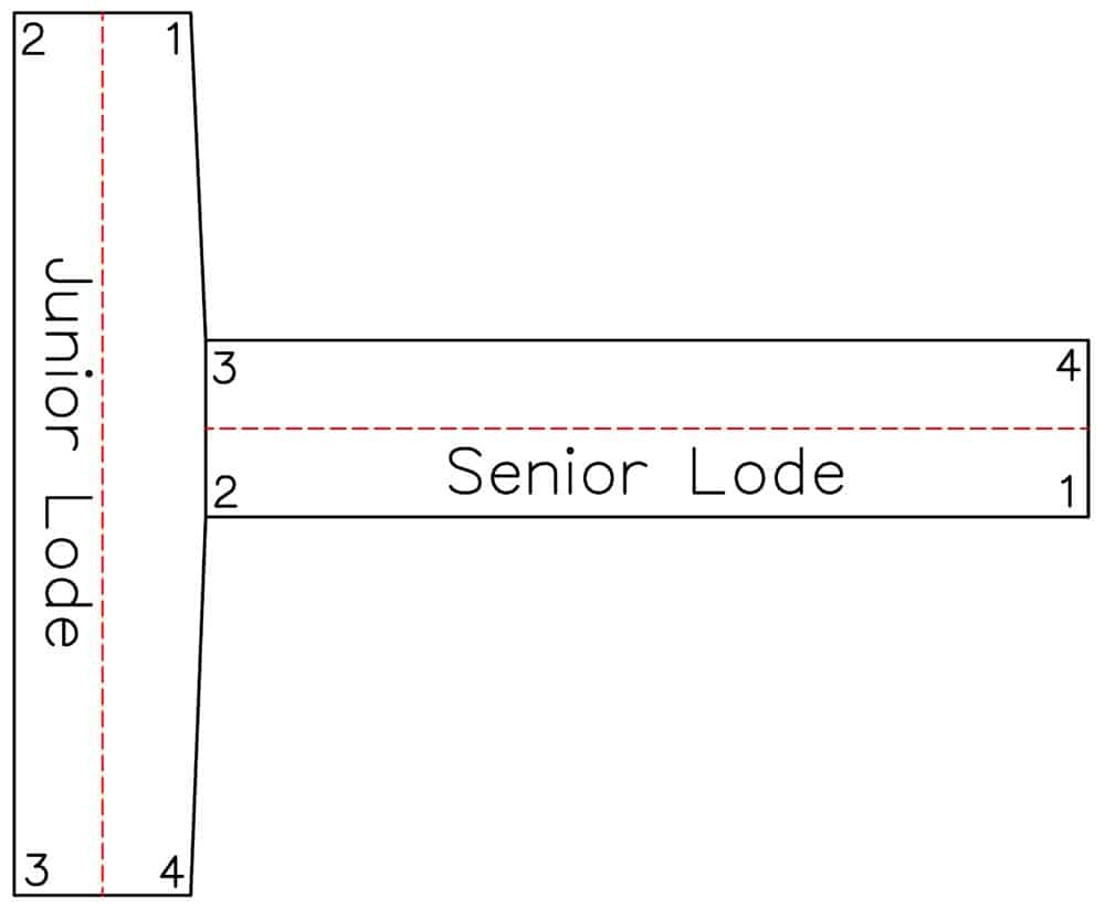
This first example is a situation where the field notes and patent for the junior lode state, "thence from Cor. No. 1 due south 1500 ft. to a point on Line 4-1 of the senior lode, thence due west 300 ft. along said Line 4-1 of the senior lode to Cor. No. 3, from which Cor No, 1 of the senior lode bears due west 580 ft...." The field notes and patent clearly indicate that Line 4-1 of the Senior Claim is contiguous with Line 2-3 of the Junior Claim.
A careful retracement of the two lode claims found all 8 corners in their officially established postions, which shows a technical overlap of the junior lode onto the senior lode. The red dashed lines are the lode lines of the two claims.
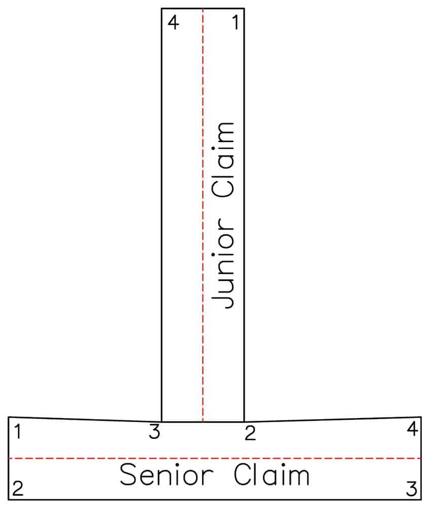
According to the instructions in Chapter X, the resurvey plat should show Line 4-1 of the Senior Claim bending through Cor. Nos. 2 and 3 of the Junior Claim as shown below.
While the Manual instructions state that this is proper, in my opinion doing so violates the Act of April 28, 1904. Original, undisturbed monuments are the supreme evidence of what land was conveyed in the patent and there is no indication that the lines of the survey are to be regarded as anything other than straight lines between the corners.
Also, since a federal patent is regarded as a quit claim deed, the Federal Government cannot convey the area in conflict to the junior claim after it was previously conveyed to the senior claim. And since both claims are patented, the Federal Government no longer has jurisdiction and therefore, the BLM has no authority to bend the senior line through the junior monuments in this example. See Steele v. Smelting Co. 1882; 1 Sup. Ct. 389, 106 U.S. 447, 454, 27 L. Ed. 226 that I cited previously in this thread.
I would treat this technical overlap example the same as if the overlap were intentional and show the lines on my plat as shown in the first figure. The area in conflict belongs to the senior claim. Anyone with a different view?
Example 2 - Technical Gap Between Junior Claim and Senior Claim.
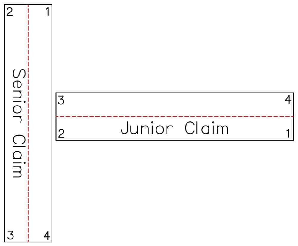
The second example is a situation where the field notes and patent for the junior lode state, "thence from Cor. No. 1 due west 1500 ft. to a point on Line 4-1 of the senior lode, thence due north 300 ft. along said Line 4-1 of the senior lode to Cor. No. 3, from which Cor No. 1 of the senior lode bears due north 580 ft...." The field notes and patent clearly indicate that Line 4-1 of the Senior Claim is contiguous with Line 2-3 of the Junior Claim.
A careful retracement of the two lode claims found all 8 corners in their officially established positions, which shows a technical gap between the junior lode and the senior lode. The red dashed lines are the lode lines of the two claims.
According to the instructions in Chapter X, the resurvey plat should show Line 4-1 of the Senior Claim bending through Cor. Nos. 2 and 3 of the Junior Claim as shown below.
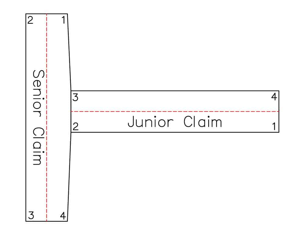
An alternative would be to treat Cor. Nos. 2 and 3 of the Junior Claim as closing corners. This method is implied as appropriate if the conditions in Sec. 10-229 are met; that being that Line 4-1 of the Senior Claim was not fully retraced, but rather only one of the Senior Claim corners was tied to in a manner similar to the old policy of closing corners for rectangular PLSS surveys prior to the issuance of the 1919 Advance Sheets.
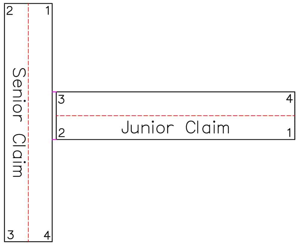
For this given set of facts, I believe that a BLM surveyor conducting an official resurvey is within their right to bend the senior line through the junior intermediate corners. It also meets the intent of the Federal Government as outlined in the first paragraph of Sec 10-229 to not, "retain unmanageable slivers of land...."
From the perspective of a private surveyor I'm uncertain that I have the authority to bend Line 4-1 of the Senior Claim through Cor. Nos. 2 and 3 of the Junior Claim. Again, my understanding of the Act of April 28, 1904 is that calls to a senior line incorporate the monuments of that senior line with the junior claim monuments and as such, Lines 1-2 and 3-4 should be closed on Line 4-1 of the Senior Claim. There are additional considerations that may change that opinion. One being whether the distance from Cor. No. 1 of the Junior Claim along Line 1-2 until it intersects Line 4-1 of the Senior Claim is longer than 1500.0 ft., which is the statutory limit under the U.S. 1872 Mining Law.
While some may regard the area of the gap as de minimus, my preference is to maintain the geometry of lode claims as contemplated in the U.S. Mining Law of 1872 and regard the junior intermediate corners as closing corners. Anyone with a different view?
P.S. to the above examples. If Cor. Nos. 2 and 3 of the Junior Claim were not found, would your solution be to place them on Line 4-1 of the Senior Claim?
Example 3 - Technical Gap Between Junior Lode and Senior Lode.
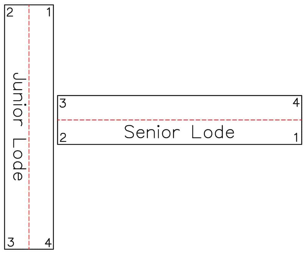
Where Example 2 had the intermediate monuments being corners of the Junior Lode, this example has the Senior Lode corners as the intermediate monuments. As such, for this example with a technical gap the senior monuments cannot be regarded as closing corners. Also, in order for the two claims to share a common line, the field notes and patent for the Junior Lode must call the Senior Lode corners as being on the Junior line. Otherwise the conditions in Sec. 10-224 are not met.
In this example, the field notes and patent for the Junior Lode state:
Thence from Cor. No. 4 due north
580 ft. to Cor. No. 2 of the Senior Lode
880 ft. to Cor. No. 3 of the Senior Lode
1500 ft. to Cor. No. 1, being the point of beginning.
The Junior Lode field notes and patent also note that all lines were run directly on the ground, which indicate that Line 4-1 of the Junior Lode is common with Line 2-3 of the Senior Lode.
A careful retracement of the two lode claims found all 8 corners in their officially established positions, which shows a technical gap between the Junior Lode and the Senior Lode. The red dashed lines are the lode lines of the two claims.
Since Cor. Nos. 2 and 3 of the Senior Lode cannot be regarded as closing corners, the only two options available are to leave the technical gap or to bend Line 4-1 of the Junior Lode through Cor. Nos. 2 and 3 of the Senior Claim. In this particular case, I believe another boundary principle is controlling. The resurveyor does not need to bend the junior line per the rules in Chapter X because the position of the line as run and established on the ground is controlling. In my opinion, Cor. Nos. 2 and 3 of the Senior Line are the same as line trees in a rectangular PLSS survey. As such, they are angle points in Line 4-1 of the Junior Lode.
Example 4 - Technical Overlap Between Junior Lode and Senior Lode.
Where Example 1 had the intermediate monuments being corners of the Junior Lode, this example has the Senior Lode corners as the intermediate monuments. The previous examples all showed relationships between intermediate monuments that marked an end line of a lode claim that were according to the record common to a side line of the other lode claim. In this example both lines are end lines. In Colorado prior to 1923, territory and state law mandated lode claim widths be no wider than 300 feet. In 1923, the State of Colorado changed the width of lode claims to match the Federal width of 600 ft. In order for the two claims to share a common end line, the field notes and patent for the Junior Lode must call the Senior Lode corners as being on the Junior end line. Otherwise the conditions in Sec. 10-224 are not met.
In this example, the field notes and patent for the Junior Lode state:
Thence from Cor. No. 1 due north
140 ft. to Cor. No. 1 of the Senior Lode
440 ft. to Cor. No. 4 of the Senior Lode
600 ft. to Cor. No. 2
The Junior Lode field notes and patent also state that all lines were run directly on the ground, which indicate that Line 1-2 of the Junior Lode is common with Line 4-1 of the Senior Lode.
A careful retracement of the two lode claims found all 8 corners in their officially established positions, which shows a technical overlap between the Junior Lode and the Senior Lode. The red dashed lines are the lode lines of the two claims.
In this example as in Example 3, I believe that Line 1-2 of the Junior Lode as run on the ground controls. Cor. Nos. 4 and 1 of the Senior Line are the same as line trees in a rectangular PLSS survey. As such, they are angle points in Line 1-2 of the Junior Lode. While this seem contrary to the requirement that the end lines of lode claims must be substantially parallel in order to preserve the extralateral rights of the lode claim, that does not mean that the retracement surveyor is at liberty to ignore evidence of the line as run on the ground. The resurveyor is not charged with fixing a prior mistake that may impact the claimant's bona fide rights.
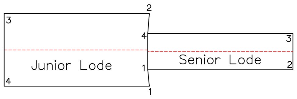
This particular example is one that I surveyed and my plat showed the junior end line with two angle points.
Quite the Cookbook there, Gene.
Warren,
Perhaps one of my recipes will get a mention in the survey noir, Chronicles of PLSSia.
Nah, I'm just too uninteresting.
