

I did not hear any mention on the news about the fact that much of the Houston area has subsided significantly over the last few decades. I believe it has slowed, but surely that must be a factor in the flooding. Of course, no city anywhere could withstand 50 inches of rain.
It occurred to me that the Trimble RTX system would be a great tool down there because it would be immune to subsidence (of benchmarks, reference stations, etc), as it is a PPP solution that does not rely on local CORS.

Lots of interesting work has been done monitoring subsidence in the area. See: http://hgsubsidence.org/subsidence-data/
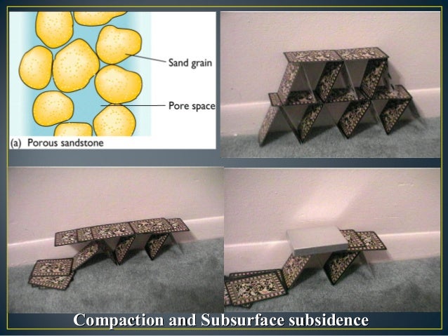
The efforts of the HGSD address concerns over groundwater withdrawal and resulting compaction/consolidation of sediments.
Part of the monitoring includes ties to extensometers which are mostly immune from close surface effects. Check out papers and presentations by the late Dr Roy Dokka of LSU who addresses subsurface effects.
John Hamilton, post: 443754, member: 640 wrote: I did not hear any mention on the news about the fact that much of the Houston area has subsided significantly over the last few decades. I believe it has slowed, but surely that must be a factor in the flooding. Of course, no city anywhere could withstand 50 inches of rain.
It is true Houston has subsided significantly over the years, however it has not been the last few decades. Other than a area in the NW part of Houston (Harris County), there has been no significant subsidence since the 1970's.
Heard something like 11 trillion gallons of water are on the ground. At 8.4lbs/gal that's near 460 billion tons of weight. Wonder what kind of surcharging that does...
Fredh, post: 443885, member: 12570 wrote: Heard something like 11 trillion gallons of water are on the ground. At 7.7lbs/gal that's near 425 billion tons of weight. Wonder what kind of surcharging that does...
The surcharging happens further up the watershed, and I wish I could dig up a quick graphic for this. There are two .. ? aquifers that service the greater Houston area.
I've read somewhere it is considerably more difficult to recharge the aquifer than it is to deplete it, and the recharge won't correct - read uplift - the collapsed areas.


Excessive pumping of water from underground aquifers and saturated soils also leads to subsidence.
Much of that has occurred on the east side of Houston in order to build and maintain newer subdivision.
That with designed viaducts and containment ponds all around Houston to hold surface runoff from residential streets that connect to drainage system of wide and deep channels to control much of the water.
That system was probably full after the first day of the storm.