NGS has updated their iconic NOAA Manual NOS NGS 3 with an alternative river crossing method. The old method worked well but required special equipment and training,
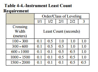
The new method uses optical theodolites (no EDM required), but of course a good total station would work as well. Basically you need two instruments and two sets of custom targets. Not just any old instrument will do, here is a table from the document:
I have a Wild T3, Wild T2, Wild T3000, and a Kern DKM2. Now I have something I can use these fine old instruments on. We have a number of locations where we need to do this, but even though I took the river crossing class at Corbin (NGS), I did not have the equipment that was required before this new method was approved.
Here is a link to the document:
New River Crossing Method using theodolites
I had developed my own method in 1988 using two theodolites (and EDM's), and we did 5 crossings with 3 other crossings places where we could cross on dam piers as well to prove the accuracy. That was part of a 130 mile second order class I level line. The procedures were similar but not the same, my method required EDM's on both sides, but the line of sight did not need to be horizontal. Also, I used stadia methods to transfer the elevation from each instrument to a nearby invar (not bar coded) rod. But, I no longer have any non bar coded rods.
Now I just need to get some targets fabricated.
Thanks for posting this. Very much needed from time to time. Would be nice if they followed up with something on higher order trig leveling. I know they experimented with this quite a bit but don't think they ever settled on a particular method for approval. I used to have a fine set of papers on trig leveling from Charlie Glover, formerly of the NGS. He was getting second order class I results. He was using some fabricated rods of a set height and, I believe, a Wild T2000 theodolite (the electronic successor to the T3).
I recently bought a T3000, not for any particular reason except I was going to mess around with it doing astros. Now I have something it can be put to good use for.
I am a big believer in trig heighting, we use it a lot to get to inaccessible points. We also do a LOT of second order leveling using digital level, invar rods, etc, mainly because specs require it. I think in a lot of cases we could do trig heighting and get comparable results.
We just finished our third annual releveling of a subsidence monitoring network that has about 16 km of runs to tie in all of the points. The initial run and every 4th year is second order class I and bluebooked, the intermediate runnings are second order class II and not bluebooked. I believe with the right procedures we could do this by running a trig height traverse.
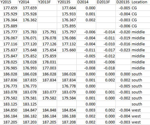
Here are our results (meters)...the Dxxxx columns are differences for each survey from the latest, 11/2015 survey. In each case one single mark in the south was held fixed, and a minimally constrained adjustment was done. It is pretty obvious that the points in the "middle" are subsiding at a somewhat consistent rate. These are all deep rod marks, some existing NGS and ten new ones we set that were driven to at least 100 feet.
The "CG" category stations are at a water level gage, and the third one down is on the foundation of a structure which has the water level gage and a CORS attached. So at least they are somewhat stable, not as bad as the "middle" stations. But, two of the "middle" stations are what was used to check the marks at the gage. But the "CG" marks are all quite far from the "stable" marks in the south.
This is all due to mining that is 2000' down.
Good measurements with the T3000; I was lucky to get one on government surplus a couple years back. Dave Ingram hooked me up with a scope mount D1000. Fun times, enjoy it John
Yea, I got my T3000 from Dave. I have taken a few lunar azimuth shots with it, not much else yet.
Interesting settlement results. I assume they are in feet not meters. If so it doesn't look like things have settled very much although I don't know what amount of settlement is acceptable. It haven't done much leveling in years, but when I last did leveling it seemed to me like trig leveling was the way to go. With the amazing compensators in instruments today there is no longer anything magical about being level anymore as vertical angles can be measured and corrected automatically to amazing precision. So with a minimum of specialized gear and methods it seems that levels could be run with longer sights and up and down hills much faster than with conventional methods.
actually the results are in meters
If the results are in meters, then 2 cm could certainly be significant in some circumstances. Can't help but be curious about what kind of mining is going on 2000 feet below.
If the results are in meters, then 2 cm could certainly be significant in some circumstances. Can't help but be curious about what kind of mining is going on 2000 feet below.
I got to witness one of the tests of the new NGS procedure. It was quite interesting. We shot between 2 1st order marks that were 2 km apart as the crow flies and about 5 km by road bridge and foot path. The difference was less than 2 mm. These 2 marks were part of a loop that involved a river crossing using the previous technique and digital levels across the bridge for a check. We have several places where this technique will be used in the future.


