Rich., post: 387766, member: 10450 wrote: I can only compare it to this area. Which is like the wild wild west when it comes to surveying. It seems like there are no rules. It's kind of annoying once you read about other areas
We have so many rules we divide them into Spanish Law, Mexican Law, Texas, some are Civil and some are Common law.
Rich., post: 387766, member: 10450 wrote: I can only compare it to this area. Which is like the wild wild west when it comes to surveying. It seems like there are no rules. It's kind of annoying once you read about other areas
My habit when I'm working in an old (meaning; 19th or early 20th century) subdivision is to adjust my surveying goggles to filter out everything that is less than about T=40 years old and try to see the patterns that existed before then. In parts of Houston that were completely built up before 1900, a value of T=116 years will probably work better. There typically was a fairly orderly status quo that the later mayhem of surveys made on the run or following some pet theory ignored or attempted to overthrow for no good reason. Usually that order can be best explained by the pattern laid out by the original survey, "usually" being the key word there.
Monte, post: 387584, member: 11913 wrote: Kent, the County Clerk will not let you file the report in the OPR books? I know many clerk's are steadfast in what they will accept, so I'm ready to hear they won't, but in some panhandle counties we have been filing reports in OPR. The clerk lists the survey firm as Grantor, the property owner as Grantee, and ties the record to the property, and the abstract firm includes the record in the abstract record. (Disclosure, we are an LSLS firm, so we are also filing our reports in the Surveyor's Records when we can get the clerk to open those records)
Locally, I've found many property descriptions that were recorded in the County Clerk's office and filed by the surveyor.
Filed in the system as Surveyor to Land Owner.
The practice has practically stopped after the recording cost has increased and the fact that many land owners do not want the county to know the most recent survey has shown more acres that would increase the amount of property taxes.
Jack Chiles, post: 387741, member: 24 wrote: ...For your complaint about Kent's words, Kent's arrogance is tolerated by those here only because he is such a damned good surveyor..
We all know how concise (picky) Kent is about his surveys...but geezus, you really didn't have to say that....now Kent's gonna have to buy a bigger straw hat at the five and dime. And I bet he goes home tonight, trims his cookie duster and spends and extra 15 minutes in the mirror telling himself what a good looking sumbitch he is...
We'll never hear the end of it now....
A Harris, post: 387781, member: 81 wrote: Locally, I've found many property descriptions that were recorded in the County Clerk's office and filed by the surveyor.
Yes, I've seen those recorded and referenced in subsequent conveyances for description. That is, land surveyor records field notes in affidavit to the Public and later deed cites that instrument for description. The essential ingredient is that a conveyance in the chain of title mention the affidavit and that the reference be continued. Otherwise, the affidavit wouldn't show up unless you're abstracting the title on the tract.
The obvious problem is that it fails to describe the land by metes and bounds in the actual deed of conveyance and so defeats any claim under a statute of limitation that would depend upon the land being described in the deed, but apart from that, it would be invisible to anyone (or their surveyor) not in the chain of title.
paden cash, post: 387786, member: 20 wrote: We all know how concise (picky) Kent is about his surveys...but geezus, you really didn't have to say that....
Well, the whole point of posting some of this stuff is just to give the young and impressionable a glimpse of that other world to which they may never had any exposure. The ultimate test of any survey is how well it writes up, and if more surveyors were to consider their work from that standpoint, I believe the profession would be well served.
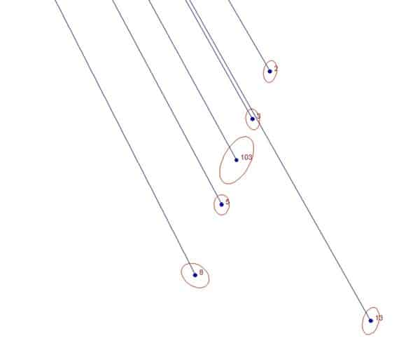
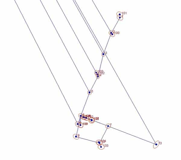
For those who may benefit from the demonstration, here's an example of how some of the control points used on the above survey were positioned. The points 1 - 20 are spikes and washers that are also plotted on the map of the survey as triangles. All fall along urban streets with plenty of traffic and obstructions. The monuments themselves are punchmarks on spikes set with stamped aluminum washers in drill holes in concrete curbs and pavements.
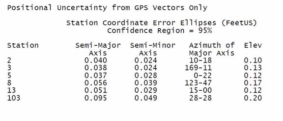
This was what the uncertainties of the positions looked like by GPS only:
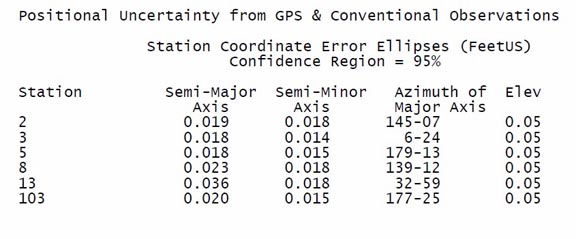
So, just looking at the uncertainties of the individual GPS-derived positions, one might think that would be as good as things could get without adding more GPS vectors. However, running conventional measurements between them and adjusting both GPS vectors and conventional measurements in an LSA program like Star*Net made a significant improvement.
The "magic" that reduced the uncertainties by roughly 50% from the GPS-only solution was from several GPS-derived positions being connected by ties with sufficiently small uncertainties in direction and distance.
And by the way, you'll note that the surveyor's report dealt with virtually none of the technical details of how measurements were made or what the uncertainties were. In my opinion, those details are nearly always a distraction from the more important things to be discussed. It should be assumed that a land surveyor knows how to make accurate and reliable measurements.
Kent McMillan, post: 387823, member: 3 wrote: And by the way, you'll note that the surveyor's report dealt with virtually none of the technical details of how measurements were made or what the uncertainties were. In my opinion, those details are nearly always a distraction from the more important things to be discussed. It should be assumed that a land surveyor knows how to make accurate and reliable measurements.
Shouldn't the instrumentation used be noted at least so in 100 years from now if someone was to retrace ol Kent McMillans work they would know he used one of them ancient edm gizmos or the antiquated gps thingys?
Rich., post: 387837, member: 10450 wrote: Shouldn't the instrumentation used be noted at least so in 100 years from now if someone was to retrace ol Kent McMillans work they would know he used one of them ancient edm gizmos or the antiquated gps thingys?
No, I left around 20 permanent control points that are easy to find and GPSable (mostly), and I provided their coordinates on the map. Those should provide a superior way to demonstrate the survey accuracy.
Yes but once they have those new machines that read to the
.0000000000001' and your monuments don't check by that much or a bit more, they should understand how it was originally measured [emoji23]
Rich., post: 387855, member: 10450 wrote: Yes but once they have those new machines that read to the
.0000000000001' and your monuments don't check by that much or a bit more, they should understand how it was originally measured [emoji23]
I'm afraid you're overlooking the obvious point that the exact same equipment in different hands can produce results with wildly varying accuracies, depending upon the details of how it is used.
Given present trends, there is no particular reason to think that we are going to see positioning with much better accuracies than +/-2mm s.e. anytime soon. Given that construction tolerance and physical monuments are unlikely to ever be hugely different than present day practices, they will fix the practical limits of survey accuracy expectations long into the future.
In fact, with the widespread use of RTK, one probably would be safer betting that survey accuracy will actually decline, settling somewhere slightly under +/-2cm as being "close enough". So those future surveyors you have in mind may just end up scratching their heads about how someone was able to get such incredibly good results using the primitive tools of the early 21st century.
Kent McMillan, post: 387861, member: 3 wrote: I'm afraid you're overlooking the obvious point that the exact same equipment in different hands can produce results with wildly varying accuracies, depending upon the details of how it is used.
Given present trends, there is no particular reason to think that we are going to see positioning with much better accuracies than +/-2mm s.e. anytime soon. Given that construction tolerance and physical monuments are unlikely to ever be hugely different than present day practices, they will fix the practical limits of survey accuracy expectations long into the future.
In fact, with the widespread use of RTK, one probably would be safer betting that survey accuracy will actually decline, settling somewhere slightly under +/-2cm as being "close enough". So those future surveyors you have in mind may just end up scratching their heads about how someone was able to get such incredibly good results using the primitive tools of the early 21st century.
That could be what my grandfather said when he bought his new steel tape to replace his old chain! "Eureka! It is graduated in 10ths!" Haha.
No no but I hope your right. Sometimes I feel we would be better off having nothing graduated past feet to use.
Rich., post: 387862, member: 10450 wrote: Sometimes I feel we would be better off having nothing graduated past feet to use.
I'm sure that there are plenty of folks willing to hold your beer and watch.
Kent McMillan, post: 387627, member: 3 wrote: In this case, the reason why I was meticulous about replacing it is that there was a good chance that the responsible surveyor would be asked to write a large check and the brand new rebar that he had relied upon as a controlling monument was part of the whole sad saga of what he had failed to do.
I got that after I posted my question. I didn't read down to your response.
Kent McMillan, post: 387791, member: 3 wrote: Well, the whole point of posting some of this stuff is just to give the young and impressionable a glimpse of that other world to which they may never had any exposure. The ultimate test of any survey is how well it writes up, and if more surveyors were to consider their work from that standpoint, I believe the profession would be well served.
Great statement Kent and much appreciated. Especially in the "get it done, we want this project to go to construction in the spring" world we live and were trained in. I see more surveys that are trying to hide the unknowns than explain them and solve them. Thanks again good post. Jp
Kent McMillan, post: 387863, member: 3 wrote: I'm sure that there are plenty of folks willing to hold your beer and watch.
Ok Ok ha. Let me rephrase... current technology but data collectors that only display the feet and no decimals. 🙂 that way when you go 100' you find THE pipe and not A pipe off 2 tenths. [emoji16]
I wouldn't mind if we only reported distances to the nearest foot. I mean if everybody applied the theory of significant figures in their work; what does it matter? It should all wash in the end. 😉
The only trouble is Oklahoma's Minimum Standards. They specify reported distances to be either the hundredth of a foot or to the millimeter. Narrow minded bastards...
In the end, did the physical properties (c/l, curbs sidewalks)of the streets that were reestablished by your survey work differ from your monuments. curious


