LRDay, post: 413794, member: 571 wrote: Even if this thing holds, (I think it probably will)
Paul in PA, post: 413805, member: 236 wrote: Of even greater concern is that the snowpack above the dam is 150% of normal. Repairs cannot be made in time to meet the expected spring peak flow.
From an engineering perspective, what is your prognosis concerning imminent failure?
As Paul mentioned, the media hype doesn't seem to concern itself with the engineering aspects, only the drama of the situation.
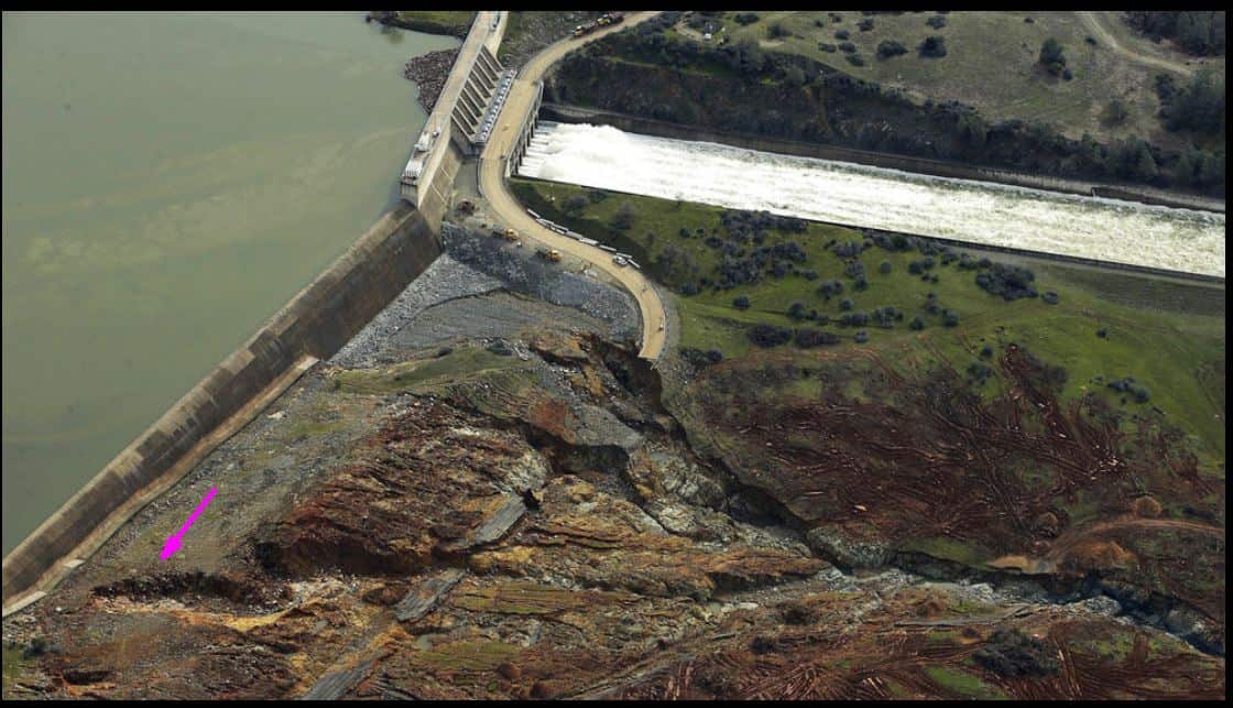
With all of the exposed bedrock below the emergency spillway, I highly doubt the emergency spillway was constructed on embankment (especially considering it is perched on the top of a mountain ridge). It is essentially a 30' tall dam.
Because the ground is saturated, even small storms will result in massive storm water run-off. Even a small storm system will result in a rapid rise in water levels due to the saturated ground.
Has anyone heard what the max. volume of water is that they can release through the mail spillway gates?
I believe it is designed for over 200,000 cfs, but the highest flow ever released through the now severely damaged spillway was 165,000 cfs in January 1997,
Thanks...So the potential failure of the emergency spillway may have been averted by releasing significantly more water down the main spillway. Of course that presented it's own unknown consequences.
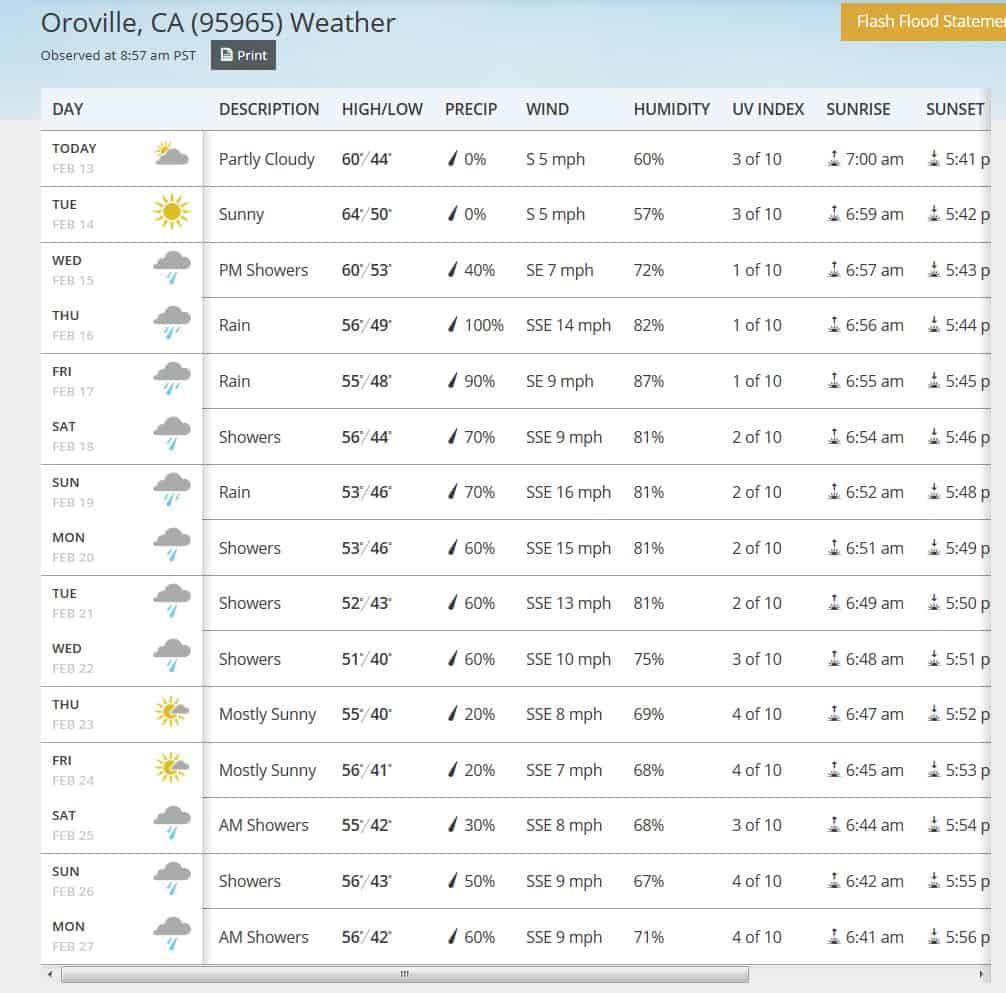
Looks like a couple days of rain....more moisture. 3600 square miles is a lot of area to capture storm water...
Paul in PA, post: 413805, member: 236 wrote:
1. There has been withholding of information to the public.Yesterday it was impossible to get any updated video. ......
The few photos I found indicated the severe erosion below the emergency spillway.2. One photo showed the water level covering the parking lot to the northwest of the emergency spillway, with runoff to areas never anticipated in the original design.
3. The most recent video shows that the emergency spillway was not founded on bedrock and as the erosion continues would undermine the emergency spillway......
I spent hours on the phone with my brother, another engineer and we pieced together information from many sources.
4. Our concern is that the reservoir has been very low for a long time and they allowed it to fill to capacity too quick to properly allow the earthen fill to resaturate. There are unknown changes within that dam due to that rapid resaturation. I would say that policy makers over rode the engineers on time to refill the reservoir.
5. Of even greater concern is that the snowpack above the dam is 150% of normal. Repairs cannot be made in time to meet the expected spring peak flow.
6. Oh, by the way this is California and even the slightest tremor could cause failure of the 770' high main dam.
7. Environmentalist have requested for years that upgrades be made to the emergency spillway, well now that repair can start with a fresh drawing board.
8. Speaking of environmentalists the Cal people had been busy this past week trying to evacuate the salmon downstream and only got around to the people yesterday.
Paul in PA
Paul, as a civil engineer and land surveyor who has lived his entire life near Lake Oroville, I have some different opinions of the facts and arm chair analysis you have presented. I have taken the liberty of enumerating your comments for the benefit of a point by point discussion.
1. I have not felt there has been a withholding of information. The local news channel KRCR7R, the Redding Record Searchlight and the Sacramento Bee have provided good reliable information to the local population. Instead, I am of the belief that the DWR and Division of Dam Safety have made a series of miscalculations and have not understood the integrity of the 2 spillway systems.
2. I'm not so sure it was "not anticipated" in its original design. A full review of the original design plans and analysis reports would need to be performed to make this observation. Anything less than such a review is simply speculation.
3. Again, a full review of the original design reports and analysis reports would need to be performed to make such an observation. Anything less than such a review is simply speculation. Although the DWR became concerned due to the upward migration of a headcut in soils immediately below the overflow of the emergency relief wier, the foundation construction depths and anchoring would still require a full review of design and as builts. Again, anything less than such a review is simply speculation.
4. The dam itself is not at risk of being compromised. The draining/refilling cyclic operation and drying/saturation process of the main dam structure is not at issue here. Both the main spillway and emergency overflow wier are not located on the dam but rather are constructed on adjacent natural slopes.
5. The snow pack is of concern, but not necessarily. If normal snowmelt patterns occur, the runoff over the spring and early summer is easily managed. Of more concern are the magnitudes and temperatures of storms during the remaining storm season. A warm and heavy storm could melt snow causing high runoffs. This is what happened last week when warm and very intense rainfall melted much of the snow in the 4,000-6,500 foot level and the reservoir filled extremely quick. There is still a ton of snow at higher elevations which pose a risk but there is a good chance that the snow will melt at normal rates which are manageable.
6. Oroville dam has already been exposed to direct earthquakes significantly larger than the "slightest tremor" you indicated. Discussion on this subject matter would entail a full review and analysis of the dam's spectral response. Anything less would be simply speculation.
7. Again, this would entail a full review of the emergency overflow wier's original design and operational reports. Anything less would be speculation. Obviously the degree of erosion that occurred is beyond being unacceptable. It is beyond my comprehension how the original design could not have taken this into account. However without reviewing the design plans and operational reports I would simply be speculating.
8. Evacuating the juvinile salmon from the downstream fish hatchery occurred due to the failure of a lower portion of the main spill way last week which caused erosion of an adjacent hillside resulting in excessively muddy water into the hatchery waters. Evacuation of persons occurred when flows were reduced on the main spillway and the lake rose quicker than anticipated and the dam operators chose to allow the emergency wier to overtop instead of increasing flow to the damaged main spillway. After 2 days of emergency overflow a large headcut started migrating rapidly towards the weir's base. This caused emergency response personnel to order evacuations.
Fortunately the response to increase flows over the damaged main spillway has paid off so far. The damaged main spillway has been able to withstand the higher flows and the lake level has dropped quickly to where there is no longer any overflow of the emergency wier and the erosion below it can now be analysised and hopefully mitigated.
I pray that decisions on how to proceed on mitigation of the situation will be successful. There are a lot of lives and infrastructure at risk. Again, the one bright spot is that the damage on the main spillway did not migrate up the spillway when the operators increased flows to 100,000 cfs last night. I understand they are going to stay with that flow rate for now to continue to decrease the lake's level. So far it appears that bedrock formations below the main spillway are now dissipating the spillway flow forces and erosive action on the main spillway has subsided.
Here is some aerial footage, jump ahead to about 6:00 minutes into the video...
[MEDIA=youtube]K28mHWrV3AM[/MEDIA]
FL/GA PLS., post: 413837, member: 379 wrote: From an engineering perspective, what is your prognosis concerning imminent failure?
As Paul mentioned, the media hype doesn't seem to concern itself with the engineering aspects, only the drama of the situation.
Without seeing the cross sections of the spillway and its foundation its nothing but speculation about whether some failure is imminent. I for one can't imagine that the spillway is not founded on strong material especially considering that storage volume is more concentrated in the top of a reservoir. At a minimum there would be a cutoff wall into some impervious foundation material.
I appears to me that the spillway is a gravity dam which means it needs to weigh enough to sit in place and not overturn or slide due to the forces from the water against the front. That would require a firm foundation. But I've not seen any cross sections so can't really say. I still can't imagine that during that time period, which was the climax and heyday of dam building, that some oversight occurred in a pretty basic design consideration such as the foundation of a dam of that size and scope.
There is probably some politics involved here. Like I mentioned before I think they are going to need and drain that reservoir to effect the repairs. The reliance on the water supply below that dam has got to be truly huge. Now that there has been an emergency including a large evacuation the public's acceptance that they must drain the reservoir is more likely to be accepted. A drought in the middle of a super wet spell, how do you sell that?
That last video mentions that the erosion that is occurring where the parking area and concrete spillway meet is what is of concern. In other words, the water should not be over topping the parking area.
I wonder if the parking area was built later over the top of some sort of concrete structure?
LRDay, post: 413794, member: 571 wrote: every bit of overburden above bedrock would be stripped if it ever flowed more than a little
A CoE dam here had a lot of water go over the emergency spillway in 1993. I don't think the structure was significantly damaged, but it did strip a lot of area below, forming what is now called the Devonian Fossil Gorge. The stripped area was expanded in 2008's flood.
https://en.wikipedia.org/wiki/Coralville_Lake
http://www.mvr.usace.army.mil/Portals/48/docs/Recreation/ODC/DFGbrochurenov2010_000.pdf
Yes, I would be interested to know what went wrong with that 2'+ thick slab of reinforced concrete.
I wonder if they experienced some severe freezing temps this winter that contributed to concrete spalling?
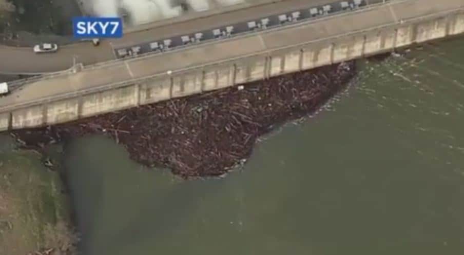
imaudigger, post: 413859, member: 7286 wrote: What happens to this woody debris when the lake level is lowered below the release gates? I guess there must be a trash rack that prevents logs from getting lodged into the mechanisms. I kind of expected to see a crane or something continually removing logs.
The large Mississippi River spillways here (Bonette Carre) have a gantry system to open,close,and rake the gates.
Not exactly the same, but a lot of debris builds up behind the tainter gates on the navigation locks that we monitor. I asked why they don't remove the debris (lots of plastics, trash, logs, etc). They said then they would have to pay to dispose of it, so they wait for high water, open the gates, and it flushes down to the next dam. Then the next dam does it, and it repeats all the way down the river.
SPMPLS, post: 413845, member: 11785 wrote: I believe it is designed for over 200,000 cfs, but the highest flow ever released through the now severely damaged spillway was 165,000 cfs in January 1997,
Scott, I bet you're glad that you're no longer with DWR.
[MEDIA=youtube]qaOwDSmiB44[/MEDIA]
Bill93, post: 413862, member: 87 wrote: A CoE dam here had a lot of water go over the emergency spillway in 1993. I don't think the structure was significantly damaged, but it did strip a lot of area below, forming what is now called the Devonian Fossil Gorge. The stripped area was expanded in 2008's flood.
https://en.wikipedia.org/wiki/Coralville_Lake
http://www.mvr.usace.army.mil/Portals/48/docs/Recreation/ODC/DFGbrochurenov2010_000.pdf
Coralville is an earthen dam and what you see in the photos above would have already washed away the dam if it occurred there. The COE is very careful with overflows on earthen dams for this reason.
Assuming the structure above is appropriately anchored in bedrock then the dam should hold. Not knowing the topography of the area, the washing out of the emergency spillway could lead to water going places that it was not intended to go.
Steve
5 to 8" of rain is expected this weeken per KRCR.
This article indicates bureaucratic failure a decade ago.
https://www.yahoo.com/news/california-dam-managers-dismissed-flood-230544249.html
Jim Frame, post: 413888, member: 10 wrote: Scott, I bet you're glad that you're no longer with DWR.
I am glad that none of the work my group did while I was there is in any way related to what has transpired and the questions that are being asked. I know many of the folks who are on the ground dealing with this though and have several friends and co-workers who have been displaced by the evacuations. It is going to a be a crazy construction season this summer at Oroville and many other areas of the state.


