I visited the Pasadena Museum of History for 2 1/2hrs today and came up with some gold.
Goodwins Subdivision, Lot 6 - 1885
Lots 7 and 14 are now Raymond Avenue. A 10 foot widening has taken place on Walnut for a 70 foot wide street.

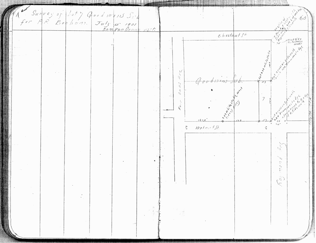
Here are some Allin Brothers field notes. This first picture is from the 2nd book I looked in..talk about luck!
July 15 1901

Looks like Allin surveyed the east side of my lot. Allin had the same problem we all do with old maps and bad surveys..no monuments. Allin was consistent though, he used the back of walks, existing walls and curb lines. Occupation surveying that made sense.
At Chestnut/Raymond, SW corner he notes this "Point on S. line Chestnut St. sidewalk, 0.10' E of W edge sidewalk Raymond Sidewalk" He came up with that 0.10' distance by measuring 75 feet west of a wall on the east side of Raymond.
His points along Walnut have been long gone. There is a possibility that the "cut cross in walk, about 0.15' from the w. edge" is still there. I'll find out tomorrow. The 2" x 2" is also ancient history.
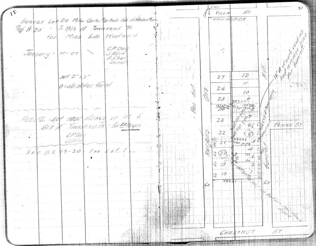
Jan 11 1907

This survey that Allin did is on the east side of Raymond to Summit. He did find some old 2" x 2"s but also used the curb line for Summits alignment, being on a 10 foot offset east of the curb. He also checked into the south edge of walk at Raymond and Villa. Chestnut is the northern bounding street of my survey and the lots depicted in this field book were resubdivided out of Goodwins Subdivision, hence his finding some stakes.
Feb 14 1910

This page is due east of my survey. He again notes his checking into the west walk edge at Marengo, the far east street and also to the south walk of Chestnut. The note about the preservation of the old stakes shows that Allin was very concientious in his efforts.
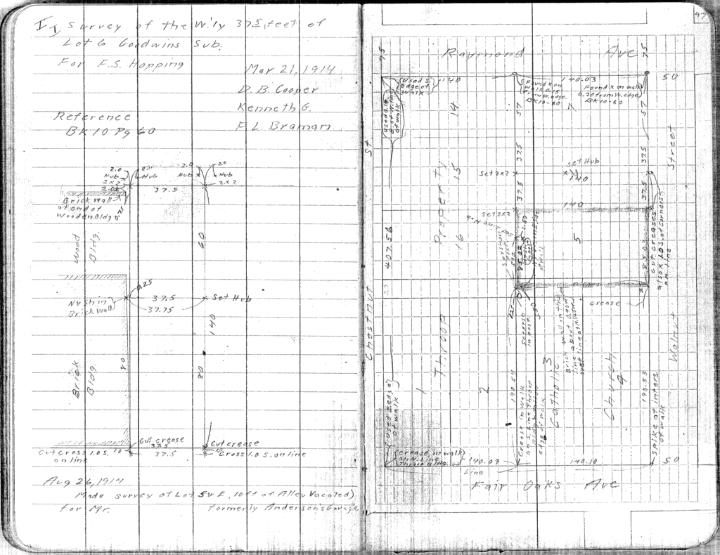
Mar 21 1914

I have to admit, I pretty much shouted when I saw this page. He surveyed the west half of lot 6. My survey is all of lot 6. The old brick wall he shows on the left side of the page towards the top is still there. He has two dimensions to the corner. From that wall edge he shows the lot line being 0.75' east, my prelim findings has it 0.83' east. He also calls out a 2.01' dimension north from the north face of the wall to the lot corner. I believe that dimension was made from the south wall edge, that works with everything else, especially the south edge of the walk along Chestnut which we located. With that assumption I match his 2.01' value with my prelim of 2.27'. This corner will be adjusted to Allin but also keeping in mind other things such as lot depth.
All in all it was a pretty interesting bit of research. Old Town Pasadena surveying is occupation first, private monuments second and centerline, well, just forget about centerline LOL:-)
Paul awesome finds.
Did you notice the party chief on that last set of notes was named DB Cooper? :-O
Love the narrative on those old notes mentioning the crosses and when they were set.
Well done Inspector Clouseau!!!
Looks good.
SJ
Method of my madness
After looking through the Allin Bros work and comparing it to what I had located in the field, I came up with what I feel is the best solution all around..
http://freepdfhosting.com/bd55e88323.pdf
I ended up using the back of walk on the south side of Walnut to fix the north sideline of Walnut at being 70 feet wide. That south B/W line appeared to be the best preserved evidence for that. The current north B/W line looks new in some areas with patches here and there.
The building corners at zero setback on the SW of the lot was held as one point for the west line. I used Allins measurement of 0.75' from the east end of the same brick wall that he shows in his 1914 work to establish a second point on the west line on the NW.
In Allins 1914 work he shows a record distance of 140.00' south of the south B/W line of Chestnut to establish the original block split line for Lots 5,6 and 7 and 14, 15 and 16, I followed suit. Allin also shows that excess was given into lots 5, 6 and 7. This solution also gives excess into those lots.
The east line of Lot 6 was held parallel with the east face of the 1926 brick building.
I jumped the gun a bit and set 5 monuments before I had Allins notes. Two were on a curb split centerline. One has to be moved 0.02' east and 0.06' south. The others are still good.
All occupation fits within these parameters except the NE corner of the brick building on the east. Its over line by 0.03' but it's coming down anyway so it's not an issue.
Interesting job 🙂
Method of my madness
Paul,
Check the spelling of "St. Andrews". You might be right, but check it.
Method of my madness
> Paul,
>
> Check the spelling of "St. Andrews". You might be right, but check it.
Hahaha ...thats a screw up if I ever saw one! Thanks Carl!!!


