It's quite simple really - just use 1" contours!
The other day we noticed a field just outside the project area was full of molehills. Out of interest we tried to process the point cloud in that area to see if we could extract them.
.jpg)
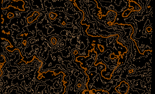
To save processing time we picked a small area with lots of hills and an adjacent one with very few. Presumably the soil conditions differed and were not to the mole's likings. The field gradient sloped generally from south-west to north-east and the area with most of the molehills produces much more fussy contours. What puzzled us was that there were some "bumps" which didn't match the image of the molehills. Was this a limitation of the way we had filtered out the rough grass.

Image above shows field with molehills - 1" contours

Second image of field area with few molehills, but rather too many circular objects
This puzzled us for a while until we thought through the logical sequence, in reverse.:
MOLEHILL - made by a mole
MOLE - made last year by a pair of moles
PAIR OF MOLES - busy last year making molehills
So: the mysterious bumps might be last years molehills which have now grassed over. Off we went back to the site and visited part of the field where there were few molehills. The result:
First lesson is that it pays to walk the site, especially if you are trying something out.
The second lesson is that if you don't look out then you won't see things.
The third lesson is that correctly applying filtering to point clouds can extract data you never expected to find.
Imagery flown from 360 ft. using a Quest Q200 fixed wing UAV fitted with a Sony A6000, main site 1000m x 600m in 20 minutes flying time.
About 100 random ground points were surveyed as checks, giving an overall mean difference with the equivalent point cloud positions of less than 3cm. 23 GCPs were placed, of which 18 were used as control (2 hours to place)
Before anybody shouts, I'm not suggesting that 1" contours are what can normally be achieved from a UAV, but there is a clear result here and we would never have thought about last years hills if it hadn't been fro the contours generated.
MOLEHILL - made by a mole
MOLE - made last year by a pair of moles
PAIR OF MOLES - busy last year making molehills
I'll have to add this to the "birds and the bees" talk with my kids.
How much did the q200 cost?
Sent from my SAMSUNG-SM-N920A using Tapatalk
arctan(x), post: 417819, member: 6795 wrote: How much did the q200 cost?
Aircraft, software, laptop, controller and training worked out at around å£25,000. Then there was about å£3000 for courses to get operations licence. You need quite a high power computer to handle large jobs so we also spent about å£3500 on a suitable laptop, which handles up to about 1500 images at a time from the Sony. In due course we will spend the same or more on a workstation to speed things up. Processing a high-res pointcloud of that many images is a long overnight run.
Biggest advantage of a fixed wing is the ability to handle changes in wind conditions once it is airborne. With a 1km radius survey taking about 30 minutes there's around 20 minutes of spare battery power left, so even if a squall suddenly blows in you can boost the speed up to 70kts. and get straight home again. Normally we fly sites at around 35kt. On auto landing you need to leave quite a lot of space to get down, but on manual landing a good pilot can put it down within a few feet of where you want, unlike the UX5. We once managed to hit the anchor pin for the launch cable on landing - fortunately no damage.


