Well...haha, sometimes they just do not go according to plan :good:
Here is a PDF link for those interested. This is the first submission copy and I will be reviewing it again for typos etc, but it was a very interesting brain teaser survey to do.
The City of Glendale have been having problems on this stretch of Mountain Street for sometime, so I have heard. It really was not that hard to sort out, once the shovel got in the ground.
What really bugs me are surveyors that just accept what's onthe surface and they know there is something amiss and adopt the attitude of "Let the next guy handle that" or "it's not my problem"..I figure if we can find 80 year old pipes, so can they.
paul,
for all the good posts you put up, i am more and more becoming an advocate for mandatory recording of plats. every state should adopt this, but probably would never happen.
Thanks Moe..
One thing of note that I did not put on the survey since it was not relevant is that somewhere between Oct 1923 and Oct 1924 the lands Ne of the C/L of Mountain were LA County properties. The centerline of Mountain was contested by the county they were calling a lot of the City of Glendales monuments off by a tenth or so. I have a CSB Map that shows those call outs.
Lynch on the other hand came in the area in 1936 and most likely used more than the one county monument he notes on his map.
Lynch was the City Engineer of Glendale from 1908 until 1918.All those guys knew each other and it's possible that Lynch had a bone to pick with Arthur J Rose, the LS/Engineer that did the tract my lot is in...
Just guessing, but anyway you slice the bread, Lynch made a poor call in not using the same point that Rose used. Rose was a very good surveyor. Lynch was also, sometimes 🙂
Paul, that's a very clean looking product you have there and very explanatory.
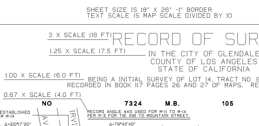
What size sheet is that and what size is the typical dimension text?
We (in a mandatory recording state) are relegated to an 18"x27" size sheet for our ROS and plats. This includes a 1/2" border top, bottom and right, with a 3 1/2" border on the left (they still put the originals in a REAL plat book here, not flat files).
This leaves us minimal room for the body of the survey and HAVE the ability to add pertinent information. Sometimes I break it up into 2 sheets just to be able to make the scale bigger and get more notes on the plat, when I would rather be able to have room just to get everything on one sheet for the layman.
Rob
Rob,
In CA, Records of Survey and Final Maps (Final Tract and Parcel maps) must be 18"x26" with 1" border on all sides. Originals are also still entered into books, but for the most part you can get copies online in many counties around CA. LA County is one of the online counties.
Last weeks one liner Survey - Rob

I use landscape when I can. Portrait is crowded. Either orientation is fine with our recorder


