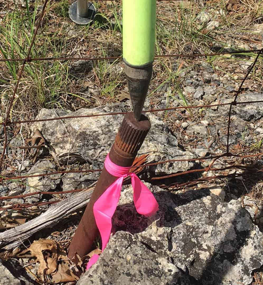
I went over to the office of a friend and colleague who worked on the survey party that drove the axle that appears in the photo below. That was in 1965 when he was 23. He laughed when I told him that at least a couple of surveyors who had seen the photo had wondered why I didn't "straighten up" the axle before locating it. My friend knew perfectly well that it had probably been driven into a fissure in the limestone and still remained most likely in the identical position as it had been left in 1965 when he last saw it.
Soooo... did he remember whether the CORNER is at the BASE, or the TOP of said axle?
:smarty:
It was a very good year for city girls who lived up the stair
Loyal, post: 435906, member: 228 wrote: Soooo... did he remember whether the CORNER is at the BASE, or the TOP of said axle?
The Point on Line was definitely at the top of the axle and the machined center was the reference point. The nature of the problem was that the axle was driven into a rock outcrop to mark the center of an old rock mound that was probably at least 33 inches in diameter. Where exactly that center was is no longer subject to review, but wherever the axle ended up was the declared center of the mound.
But did he remember the vehicle make of the axle?
paden cash, post: 435918, member: 20 wrote: But did he remember the vehicle make of the axle?
No, what he told me was that his late cousin (who I'll call "Orin" and who also was a friend of mine) had set the axles before they traversed through them in 1965. What evidently happened was that the corners were located in 1950 and a cedar hub was set in the rock mound to mark the corner and those hubs were later replaced by the axles.
My friend (who I'll call "George") had the idea that the axles were at least 30 inches long, but when I told him that some of the tool marks on the axles indicated that they were more likely halves of axles that had been cut to length with an oxy-acetylene torch, he didn't insist upon the length element.
Regardless of the circumstances I would never set anything on a non vertical angle. 😎
Future Surveyors will utilize the base of the monument shown in your pic as the corner location.
FL/GA PLS., post: 435941, member: 379 wrote: Regardless of the circumstances I would never set anything on a non vertical angle.
Future Surveyors will utilize the base of the monument shown in your pic as the corner location.
Well, I suppose it is possible that future "surveyors" won't have any conception of how axles were driven to mark the centers of rock mounds in the rocky ground of the Texas Hill Country in 1965, how strong and relatively unbendable axles are, or how plumb bobs were used to center transits over boundary markers, but I think that the odds are very much in favor of the machined center at the top of the axle being used as the reference point by whomever visits the thing in another 52 years.
FL/GA PLS., post: 435941, member: 379 wrote: Regardless of the circumstances I would never set anything on a non vertical angle. 😎
Future Surveyors will utilize the base of the monument shown in your pic as the corner location.
back in the day we set a few difficult monuments, and purposely knocked the top over to "true" position.
If I found one like this today my first response would be to tie to the base. My field notes would say something like "found 1 1/4" axle, no record. leaning East, about 0.2'. tied to base at ground level". I would probably take a few cell phone photos too.
.... the same note would be found on my recorded map with "accepted as NW corner of Lands of McMillan"
[USER=3]@Kent McMillan[/USER]
"but I think that the odds are very much in favor of the machined center at the top of the axle being used as the reference point by whomever visits the thing in another 52 years."
I'm confused, in the majority of your previous posts you are always "repositioning" anything you find to its "correct" position. :smarty:
Peter Ehlert, post: 435954, member: 60 wrote: If I found one like this today my first response would be to tie to the base. My field notes would say something like "found 1 1/4" axle, no record. leaning East, about 0.2'. tied to base at ground level". I would probably take a few cell phone photos too.
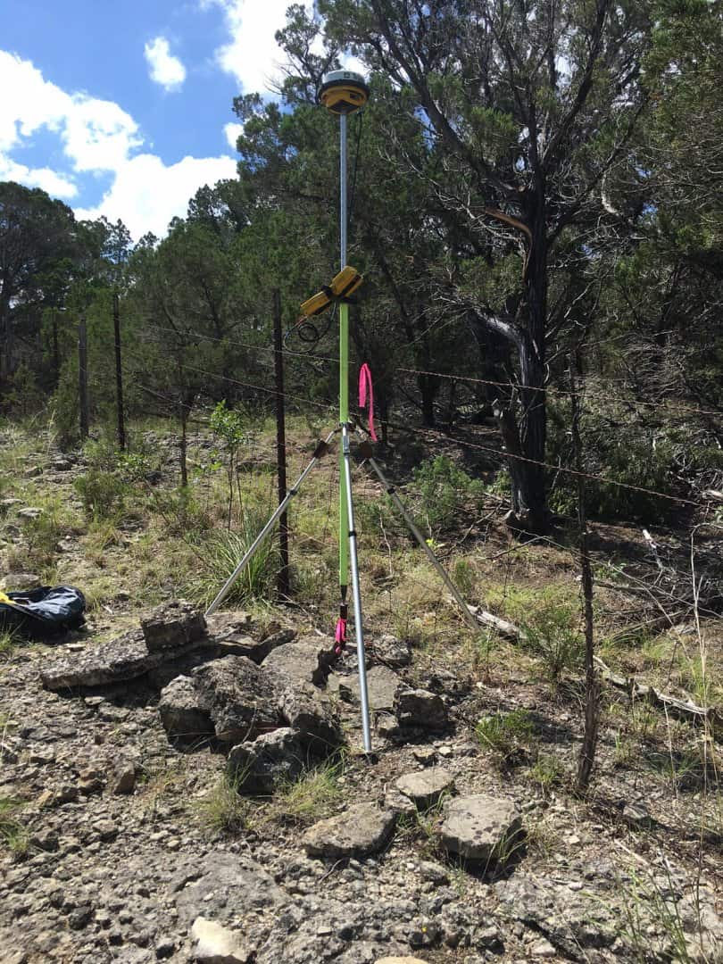
In this particular case, the axle merely provides a reference point for the rock mound that was found in place and that still exists, somewhat scattered, around the axle. So the question would be the practical one of whether the machined center on the top of the axle as driven or the center of the axle at some point approximately where it disappears into the rock fissure will be the more definite and permanent. Here's a photo showing what's left of the rock mound:
FL/GA PLS., post: 435956, member: 379 wrote: [USER=3]@Kent McMillan[/USER]
"but I think that the odds are very much in favor of the machined center at the top of the axle being used as the reference point by whomever visits the thing in another 52 years."I'm confused, in the majority of your previous posts you are always "repositioning" anything you find to its "correct" position.
No reason for confusion. The axle was set in an existing rock mound that probably was built in the 1880s to mark a corner of a particular land grant. I've posted a photo above showing the remains of the mound. As you can see from the size of the rocks in the mound, the nature of the thing resists an exact determination of its center. So the practice is to leave a reference point in the mound to represent the center.
The axle was set in the age of transit and tape and my guess is that my late friend Orin was thrilled to be able to find a spot to drive the axle where it wouldn't take an hour's worth of work with a hammer and star drill beforehand. I very much doubt that it would have ever occurred to him that some future generation with optical plummets would arrive to try to find the center of some lower cross-section of the axle when the machined center on top was looking right at them.
When I set a marker in bony ground and it wanders off its intended position, I bend the top back into place, sometimes as much as 0.1 - 0.2'. Top center is intended to be the corner. When I encounter a bent or leaning marker, I locate the top center and also the estimated location of the base.
Can't say that I've set any markers where I've guessed the corner might be, and THEN traversed and located them. I do, however, have a a rusty old "Iron Pipe Found" in the truck for emergencies.
[SARCASM]You can't use it because it's not mentioned in the Deed.[/SARCASM]
Sergeant Schultz, post: 435964, member: 315 wrote: When I set a marker in bony ground and it wanders off its intended position, I bend the top back into place, sometimes as much as 0.1 - 0.2'. Top center is intended to be the corner. When I encounter a bent or leaning marker, I locate the top center and also the estimated location of the base.
Can't say that I've set any markers where I've guessed the corner might be, and THEN traversed and located them. I do, however, have a a rusty old "Iron Pipe Found" in the truck for emergencies.
The old rock mound in place wasn't much of a guess. Even scattered at bit, it is definitely a rock mound. What that means is that the center of the mound is the point of interest unless there are ties to bearing trees that would place the corner in some more exactly determined position.
As for trying to bend a 1.25" dia. heat-treated car or truck axle of high-strength alloy steel, I'm willing to hold anyone's beer while I watch.
"Can't say that I've set any markers where I've guessed the corner might be, and THEN traversed and located them."
actually, I have done that several times... "true corner" determined from BTs or some such. Then late I "might" make some measurements to show how it relates to other gizmos.
Dave Karoly, post: 435967, member: 94 wrote: You can't use it because it's not mentioned in the Deed.[/SARCASM]
That's probably true in California, but in Texas a call for a rock mound is understood to be a call for the center of the mound and the object of the exercise is to determine its center. Where some prior survey did exactly that when the mound was presumably in lesser disarray, that is ordinarily as good as it is ever going to get.
Kent McMillan, post: 435972, member: 3 wrote: That's probably true in California, but in Texas a call for a rock mound is understood to be a call for the center of the mound and the object of the exercise is to determine its center. Where some prior survey did exactly that when the mound was presumably in lesser disarray, that is ordinarily as good as it is ever going to get.
[SARCASM]You keep saying "presumed" and "probably," what are you some kinda Lawyer?[/SARCASM]
Kent McMillan, post: 435962, member: 3 wrote: The axle was set in the age of transit and tape and my guess is that my late friend Orin was thrilled to be able to find a spot to drive the axle where it wouldn't take an hour's worth of work with a hammer and star drill beforehand.
In my world thats called "cutting corners" to "save time", thus subsequently misleading to future Surveyors.
Kent McMillan, post: 435969, member: 3 wrote:
As for trying to bend a 1.25" dia. heat-treated car or truck axle of high-strength alloy steel, I'm willing to hold anyone's beer while I watch.
No kidding...I'd buy the beer to see that!
Loyal


