
Does anyone out there know of a source for job descriptions of colonial type survey crews? You know, rear chainman and such. I'd like to give some young college interns some perspective, but I could do the jobs better than explain them.
I wouldn't mind reading more about that history. Wish the magazine publications would make more articles about the historical aspect of this profession more so than Lidar scanning, too.
I agree, my most recent issue of a big survey mag. used the term point cloud to the point that I put it down. That might be fine for some big firms, but most guys I know are still spinning angles to get the job done. These young guys I'm working with might wind up using that technology, and that's fine, but I feel they should know the history of data collection, and how it's compiled. And if I bump into them 20 years down the road, they better know how many links in a chain, and how wide a two rod road is. Man I'm getting old.
When I first started in the military we had two chainmen, an Istrumentman, a survey recorder (sketches and fieldnotes) and a Chief.
Ralph
that point cloud talk reminded me of something out of dilbert when the boss learns a new buzz word....:bad:
man Ralph- you're old......;)
> man Ralph- you're old......;)
Last I checked we were alumni of the same 82c class of 83??? ;o)
I'm just a tad uglier than you are....:o)
Good to hear from you Rankin.
BTW Do you know Tim England or a fellow last named Tribby?
Ralph
Take a look at A Treatise on the Method of Government Surveying by Shobal V. Clevenger. It was first published in 1874, but equipment and procedures hadn’t changed much since colonial times.
Part III on Page 64 has instructions on flagging, chaining, blazing, and corner building.
Bring your students to a Surveyors Historical Society Rendezvous and we'll put them through the paces.
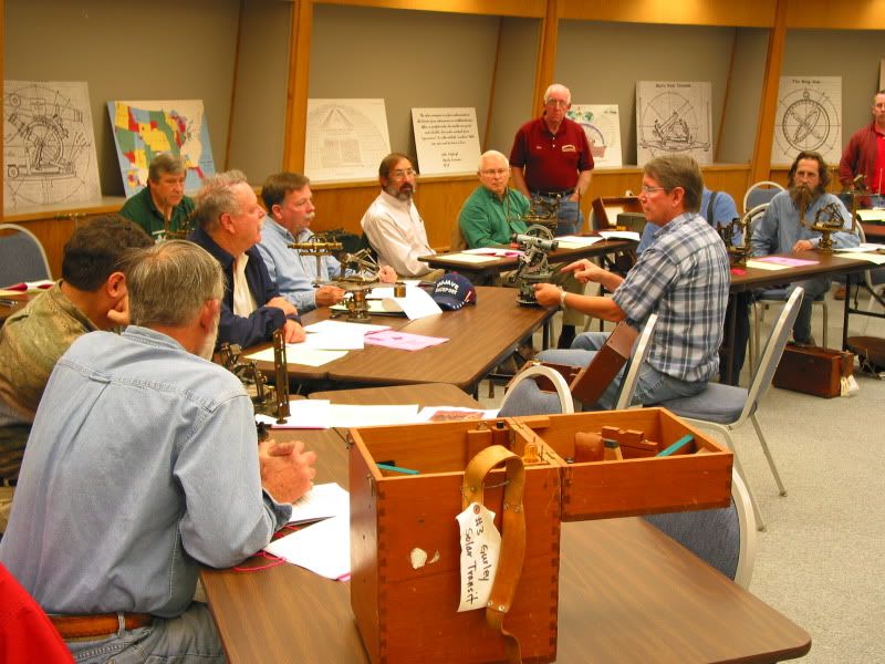
Solar Compass Class
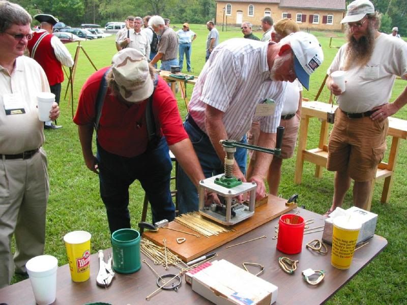
Making a Chain
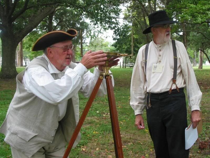
Running a Traverse

Setting a Mason and Dixon Crownstone

Andrew Ellicott and Thomas Jefferson

Topographic Engineers
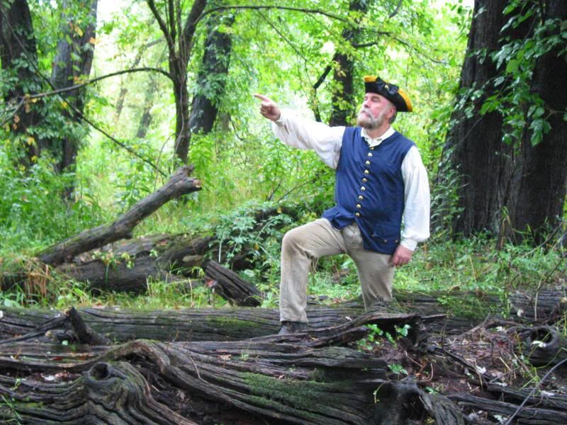
The Greenville Treaty Line

Surveying in West Virginia
Rich-
Thank you for your post.
Great Pics !!
Is a RV type visit possible for the forthcoming gathering ?
Maybe if you would please answer by my e-mail [email protected].
Cheers
Derek
Looks like great fun. My wife would just shake her head.
> My wife would just shake her head.
Would this help?


In US Army artillery survey (1961-1969) a traverse party had:
1 Party Chief SSG
2 Computers Sp5
1 Instrumentman Sp4
1 Recorder Sp4
2 Tapemen PFC
If the unit was at full strength, we often were short handed.
The 2 computers used logarithmic trig tables and preprinted forms on clipboards to compute coordinates, while walking along with the traverse party. They worked independently and checked on each point coordinate. If they were good, the computations were done at the same rate as the rest of the traverse.
Class 32-81. This (see pic), is still in my library. 
CV
The hairy faced man on the right in the first picture tells me he found a bilby tower in a Louisiana swamp.
> The hairy faced man on the right in the first picture tells me he found a bilby tower in a Louisiana swamp.
The guy who kept the reproduction Mason and Dixon Crownstone at his house before it was reset in the fourth picture told me the same thing.

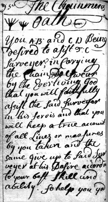
The Chainman Oath
Now is the time for all good men to come to the aid of their country. Typing class 9th grade!
Bilby Tower Quest
The hairy-faced man and the Crownstone hoarder are both on the Board of Directors of the Surveyors Historical Society. And, like me, they’re both really excited about the prospect of preserving a Bilby tower.
Really, the whole thing started right here on SurveyorConnect with this thread:
[msg=31757]Bilby Thread[/msg]
About half way down, you’ll see where I inquired if anyone knew where Surveyors Historical Society could find a Bilby tower and Bill93 and Dan Robinson responded with links to a geocaching site and a photo. I looked up the data sheet on the NGS website and plugged the lat/lon into Google Earth. You can’t see the tower too well, but you can see the shadow:

So I sent the image to the SHS board members along with the message, "Are we still looking for a Bilby tower?" Next thing I know, there is an expedition to a swamp in Louisiana. The group included representatives from Surveyors Historical Society, Louisiana Society of Professional Surveyors, Louisiana Wildlife Management Agency, Osgood, Indiana (Jasper Bilby’s hometown, where the tower will be moved if all goes well) and a retired U.S. Coast and Geodetic Survey employee.


Damn kids.
This is just another example of what a great resource SurveyorConnect (BeerLeg).com is. SHS had been looking for a Bilby tower for years. The above-mentioned thread was posted on November 10, 2010. By December 16, 2010, there had been a reconnaissance mission to Point COUBA (see photos above) and I had a report from the SHS administrator indicating the following organizations have shown interest in the project:
Indiana Surveyors Historical Society (ISHS)
Indiana Society of Professional Surveyors, Inc. (ISPLS)
Indiana Historical Society (IHS)
Louisiana Society of Professional Surveyors (LSPS)
Louisiana Wildlife Management Agency
Chevron Pipeline Company
Aeromotor (Bilby Tower and Windmill manufacturer in Texas)
C.H. Fenstermaker and Associates
NOAA
USC&GC Heritage Society
Reynolds Foundation
Ripley County, Indiana, Park Board
NSPS/ACSM
I doubt if it would have happened without SurveyorConnect. Thanks Wendell and Angel.
Bilby Tower Quest
Ditto on SurveyorConnect.com.
:good:
TM6-230, brings back memories. I'm still trying to find a smart book, I miss it.
Thanks for Sharing!
Ralph
The first word on 17th century surveying
John Love's Geodaesia eas written in 1688; it would have served as a standard reference forlate 17th and early 18th century surveyors.