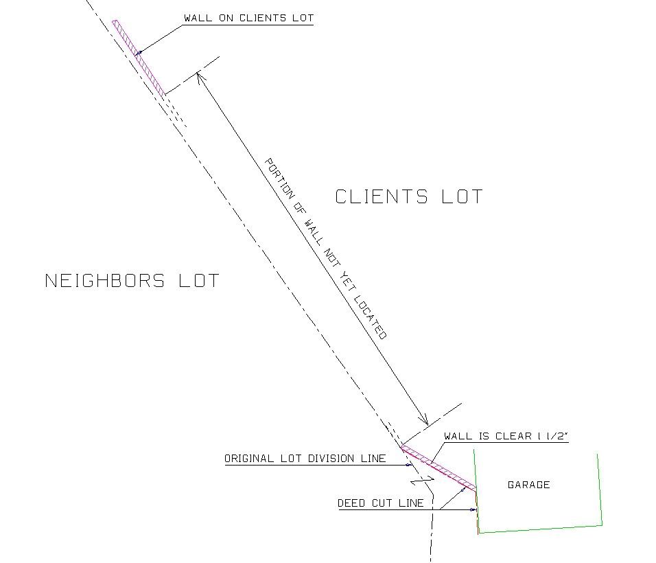
Sooner or later I knew that one of these filings would take place. It's a dumb thing to have to do, but I have to abide by my clients wishes and also go along with the state boards current position on RS filings, which could change next week..who knows??
Background..
My client, Bobbie, wants to simply know how one wall, and only this one wall, lies along the common line with her neighbor. Is the wall on her side of the line or is it a common wall, in whole or in part. She does *NOT* want any monuments set at the deed corners.
The common line that the wall follows is for the most part, shown on a recorded map which means that only a CR would need to be filed. The last 13 feet of the line deviates away from the record map line, this deviation requires an RS to be filed.
We did the survey yesterday and located the front and rear portion of the wall and from those locations all of the wall that we located is on Bobbies side of the line. There is another 66 feet of wall to still be located, which I will do this morning..an hours worth of work.
Here are a few pics...

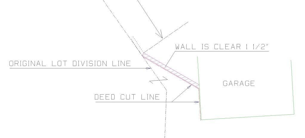
Blowup

The garage is *not an issue*.
So now I have to file an RS because I will be providing Bobbie with a private matter drawing of where the wall is in relation to the common line and because of that, I have to file an RS that will not show any set monuments.
Silly huh.
PS None of the improvements, wall or garage, will be shown on the RS either.
Provide the client and report or written narrative with exhibits and details.
Of course that's after you have detailed in your contract what your services are and what you will provide and will not provide with a detailed scope of work.
> Provide the client and report or written narrative with exhibits and details.
...I will be providing Bobbie with a private matter drawing of where the wall is in relation to the common line
California is weird.
The line is not being changed and no new monuments are being set. All you are doing is providing a measurement service as opposed to a boundary survey.
> California is weird.
>
> The line is not being changed and no new monuments are being set. All you are doing is providing a measurement service as opposed to a boundary survey.
Correct !
This is clearly a State Specific issue, that is unless we want to discuss it in the P&R category. 😉
Paul:
Governing Law would be the Land Surveyors' Act and the Board Rules
To my knowledge the Ca. Board has never waffled or changed position on this issue, nor has the AG ever issued an opinion on this point. I do believe there have been quite a number of disciplinary actions for non-filing thru the years.
1. Setting (or not setting) monuments is off point, "determination" of a boundary is the sole key.
2. A contract for services can not supersede State Law.
But, we both know all this. What do you see as your exception to the established laws in California?
I don't expect the "original lot division line" or occupation would be a trigger. Was the "deed cut" line a surprise after you started the work?
I know, it makes a financial burden on the client to pay for you to take the extra step of documenting your work, but you knew that going into the job.
But maybe things have changed and I haven't heard about it...
PS: I hope the filing fees aren't too extraordinary.
My view would be in line with what Peter has said. The fees for records of survey should be next to nothing, but no one is listening to me.
The idea that all the client needs IS- to know is where this or that feature is in relation to a boundary, is a problematic proposition. I have heard countless times, "I don't need that, I just want my 2 rear corners." This notion is a FUNDAMENTAL MISUNDERSTANDING with regard to what IS required in the delivery of service relating to a boundary survey. Boundary surveying involves the development of a profeessional opinion as to location of a boundary upon which the client is able to rely and ultimately there may be reliance on that opinon by third parties.
Because of these facts, it is not a credible proposition to maintain that the matter is strictly private. The rules licensees work under are for the protection of the public. The rules are clear and there is no exception to them for private matters, or because an individual surveyor thinks compliance with the rule is too onerous or unduly costly for the client.
The irony is that even when there is NO checking fee, only a county record fee of $10, the county surveyor still sees an appallingly low compliance response.
While I understand and appreciate the plight of your post....I do not make the rules, I just work here and the more complince the better it is for everyone....
1 1/2", why are you using inches for your units?
> 1 1/2", why are you using inches for your units?
Why not?
>
> Why not?
Agreed Paul. we need to speak in the language of the consumer.
Wait, I'm confused. Confusion #1 - The line is shown "for the most part" on a recorded survey. You aren't setting any monuments so a Corner Record wouldn't even be required to measure the location of a wall in relation to a recorded, monumented line, would it? Confusion #2 - Is it the fact that the wall deviates from that recorded survey line that you think triggers the Record of Survey requirement? Then why isn't the wall going to be shown on the map? Or is the line where the wall is located not the part of the line that is shown on the recorded map?
I forgot to open your post in a new window, so maybe my memory of the situation is wrong. Or, I'm not understanding the problem; could happen.
> Wait, I'm confused. Confusion #1 - The line is shown "for the most part" on a recorded survey. You aren't setting any monuments so a Corner Record wouldn't even be required to measure the location of a wall in relation to a recorded, monumented line, would it?
Correct.
>Confusion #2 - Is it the fact that the wall deviates from that recorded survey line that you think triggers the Record of Survey requirement?
No. The wall deviates from a recorded line and then follows a deed cut line.
>Then why isn't the wall going to be shown on the map?
Rarely do I show walls etc on a CR or RS.
Oh, I think I see now. The ROS trigger is the establishment of the deed line that's not on a recorded map yet? I've heard you say before that you don't show walls and such on your surveys. Up here, if you don't show them, the CS's ask for them. I kind of think it's good data to have on a map, if only as a guide for future surveyors to know where to look for monuments (I realize you're not setting any in this case), but also to show occupation as evidence that you at least located and considered. I'm not saying one way's right or wrong, just common practice in my area.
> ... Up here, if you don't show them, the CS's ask for them.
Down here the CS works with surveyors and does not dictate personal preferences.
Aside from that, showing improvements on any filed/recorded survey document is not a good idea for various reasons that I wont get into.


