
Actually two of them.
1. For the first time in a decade I had to go to the land records room at the courthouse. All of our plats, deeds, patents, etc. are online going back to colonial times, so except for the occasional need to rummage through old microfiche for a plat that is missing online (today's errand) there is no reason to leave your office for any research. It was strange being the only person in there except the staff and it's just not the same without 20 title abstractors talking so loud you can't concentrate.
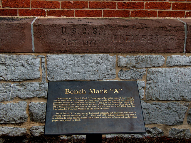
2. On the way in, stopped by to see an old geodetic friend, Benchmark A.
Level Headed: A Brief History of Leveling at the National Geodetic Survey
The First Geodetic Level Lines
Although spirit levels are mentioned in historic documents as early as 1854, the Coast Survey’s first recorded use of spirit levels to survey a geodetic-quality level line was as part of a study of the tides and currents of New York Bay and the Hudson River in 1857. Using spirit levels, G. B. Vose connected a series of tide gauges from New York City to the Albany area, proceeding with such care that in one section across a long bridge," it was necessary to run over the work five times.” Tide station GRISTMILL was established from this work and provided the mean sea level datum upon which the U.S. Lake Survey later based the elevation of water surfaces on the Great Lakes.
In 1871, Congress gave the Coast Survey (which would be renamed the Coast and Geodetic Survey (C&GS) in 1878) a specific geodetic function in addition to its charting function. Following this new mandate, the Survey began planning for a transcontinental arc of triangulation following the 39th parallel or degree of latitude. This project required the most accurate elevations to date, and thus the craftsmen of the Coast Survey’s instrumentation section designed and constructed a new and more precise level.
The new instrument was a “wye” level, so called because the telescope rested in Y-shaped supports. It sighted on a target clamped to a level rod. Use of the instrument and rods was slow and cumbersome, requiring numerous computations to correct for various factors. Nonetheless, between 1877 and 1900, more than 5,590 miles (9,000 kilometers) of leveling were completed along the 39th parallel.
The 39th parallel leveling began in October 1877 with the establishment of “Benchmark A” in the foundation wall of the Washington County Court House in Hagerstown, Maryland, where it can still be seen today. A level line was then run from the courthouse along the nearby turnpike to the aquaduct carrying the C&O Canal over Conococheage Creek near Williamsport, Maryland. As the observing seasons passed, the level line followed the C&O Canal to its end at Cumberland, Maryland, and then continued westward along railroad tracks.
As this first level line was carried west, other level lines were connected to tide gauges and run along rivers like the Mississippi and Arkansas and along various railroad lines, eventually connecting to the 39th parallel transcontinental line. Completed in the first decade of the 1900s, this leveling network not only enhanced the transcontinental survey, it also provided benchmarks at frequent intervals for engineers and surveyors in need of accurate elevations for local projects.