Reading RPLS is free for the whole profession. Members post, reply, and get the members-only rooms.

Notifications
Clear all
Strictly Surveying
12
Posts
7
Users
0
Reactions
1,002
Views

Topic starter
Translate
▼
English
Spanish
French
German
Italian
Portuguese
Russian
Chinese
Japanese
Korean
Arabic
Hindi
Dutch
Polish
Turkish
Vietnamese
Thai
Swedish
Danish
Finnish
Norwegian
Czech
Hungarian
Romanian
Greek
Hebrew
Indonesian
Malay
Ukrainian
Bulgarian
Croatian
Slovak
Slovenian
Serbian
Lithuanian
Latvian
Estonian
Did a boundary / ex-cond survey last year for client "A" (actually her son who had power of attorney) who historically owned to the red line.
In 2005 "A" granted former owner of "B" the blue line, which was done w/o a survey and only by a poor meets & bounds drafted by most likely an attorney, resulting in the angled configuration. Had a nice big note on the plan that this was an illogical line but was the best location based on the evidence available and the parties should take steps to resolve this issue.
Earlier in the summer was contact by developer "C" who was in the process of town approval for a condo project or lot "A" and the board questioning the configuration (blue) of said line. I recommended that a Lot Line Adjustment be done between "A" & "B" and even drafted a preliminary plan for the parties to review and comment on, being the green line below.
Get a call yesterday from "C" stating the project is 99% approved he has purchased "A" and the town needs the recording # from the LLA I did. The LLA plan still hasn't moved past the review stage as I never heard back from the parties. Reviewing the submitted site plans and the deed of "A" to "C", they have been using the green line for planning purposes and the meets and bounds of "C"s deed and subdivision plan all describe the green line.
So from a title point of view, as of this morning, I see it as "B" still as has title to parcel "Y" as "A" can't sell what he doesn't own and parcel "Z" still belongs to "A" as it was omitted by a very specific description from "A"s deed to "C".
Looking for thoughts how to clean up the title. First thought is corrective deed between A & C, then an LLA with C & B, but welcome your input. 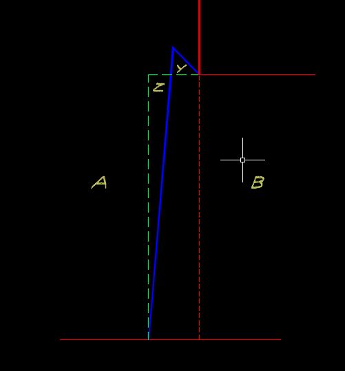
Posted : August 11, 2017 6:13 am

Translate
▼
English
Spanish
French
German
Italian
Portuguese
Russian
Chinese
Japanese
Korean
Arabic
Hindi
Dutch
Polish
Turkish
Vietnamese
Thai
Swedish
Danish
Finnish
Norwegian
Czech
Hungarian
Romanian
Greek
Hebrew
Indonesian
Malay
Ukrainian
Bulgarian
Croatian
Slovak
Slovenian
Serbian
Lithuanian
Latvian
Estonian
If the green line has gone to and through the planning process, I would say it is an agreement via of acquiescence. Acquiescence of A, B and the town.
Just make sure A and B sign any transfer document.
Paul in PA
Posted : August 11, 2017 7:03 am

Translate
▼
English
Spanish
French
German
Italian
Portuguese
Russian
Chinese
Japanese
Korean
Arabic
Hindi
Dutch
Polish
Turkish
Vietnamese
Thai
Swedish
Danish
Finnish
Norwegian
Czech
Hungarian
Romanian
Greek
Hebrew
Indonesian
Malay
Ukrainian
Bulgarian
Croatian
Slovak
Slovenian
Serbian
Lithuanian
Latvian
Estonian
It's a 2 step process.
Sneak out there, after dark, and pick up the monument at nw cor y.
Carry it over to nw cor c.
Then, edit the polyline vertex, repeating this in office.
You see, that monument is magiclly the corner. It has spiritual properties. As it moves, title moves with it.
At least, that's what my client's neighbor thinks....mmmhhhmmm!
Posted : August 11, 2017 7:10 am
Topic starter
Translate
▼
English
Spanish
French
German
Italian
Portuguese
Russian
Chinese
Japanese
Korean
Arabic
Hindi
Dutch
Polish
Turkish
Vietnamese
Thai
Swedish
Danish
Finnish
Norwegian
Czech
Hungarian
Romanian
Greek
Hebrew
Indonesian
Malay
Ukrainian
Bulgarian
Croatian
Slovak
Slovenian
Serbian
Lithuanian
Latvian
Estonian
Thats a good point, Paul, I will look into it, thanks.
Posted : August 11, 2017 7:20 am
Topic starter
Translate
▼
English
Spanish
French
German
Italian
Portuguese
Russian
Chinese
Japanese
Korean
Arabic
Hindi
Dutch
Polish
Turkish
Vietnamese
Thai
Swedish
Danish
Finnish
Norwegian
Czech
Hungarian
Romanian
Greek
Hebrew
Indonesian
Malay
Ukrainian
Bulgarian
Croatian
Slovak
Slovenian
Serbian
Lithuanian
Latvian
Estonian
Nate The Surveyor, post: 441416, member: 291 wrote: It's a 2 step process.
Sneak out there, after dark, and pick up the monument at nw cor y.
Carry it over to nw cor c.
Then, edit the polyline vertex, repeating this in office.
You see, that monument is magiclly the corner. It has spiritual properties. As it moves, title moves with it.
At least, that's what my client's neighbor thinks....mmmhhhmmm!
Reminds of a guy I worked with for a summer, way back when I was coming up. He'd pocket dried up flagging that he came across. Finally asked him why: Well you never know when you might need to "find" an old pin...
Last I heard he was working at Home Depot
Posted : August 11, 2017 7:28 am

Translate
▼
English
Spanish
French
German
Italian
Portuguese
Russian
Chinese
Japanese
Korean
Arabic
Hindi
Dutch
Polish
Turkish
Vietnamese
Thai
Swedish
Danish
Finnish
Norwegian
Czech
Hungarian
Romanian
Greek
Hebrew
Indonesian
Malay
Ukrainian
Bulgarian
Croatian
Slovak
Slovenian
Serbian
Lithuanian
Latvian
Estonian
Fredh, post: 441418, member: 12570 wrote: Reminds of a guy I worked with for a summer, way back when I was coming up. He'd pocket dried up flagging that he came across. Finally asked him why: Well you never know when you might need to "find" an old pin...
Last I heard he was working at Home Depot
One tactic (myth I assume) is to set a pin, whatever is typical in the area, and pack a handful of rock salt around it. That will accelerate its aging process. "Found IP"
Posted : August 11, 2017 7:47 am

Translate
▼
English
Spanish
French
German
Italian
Portuguese
Russian
Chinese
Japanese
Korean
Arabic
Hindi
Dutch
Polish
Turkish
Vietnamese
Thai
Swedish
Danish
Finnish
Norwegian
Czech
Hungarian
Romanian
Greek
Hebrew
Indonesian
Malay
Ukrainian
Bulgarian
Croatian
Slovak
Slovenian
Serbian
Lithuanian
Latvian
Estonian
No, it's not acquiescence, the owners can't agree or acquiesce to the green line when they know the true boundary is at the blue line. I think the OP is correct, corrective Deed from A to C then an LLA with B.
Posted : August 11, 2017 8:52 am
Translate
▼
English
Spanish
French
German
Italian
Portuguese
Russian
Chinese
Japanese
Korean
Arabic
Hindi
Dutch
Polish
Turkish
Vietnamese
Thai
Swedish
Danish
Finnish
Norwegian
Czech
Hungarian
Romanian
Greek
Hebrew
Indonesian
Malay
Ukrainian
Bulgarian
Croatian
Slovak
Slovenian
Serbian
Lithuanian
Latvian
Estonian
Dave Karoly, post: 441435, member: 94 wrote: No, it's not acquiescence, the owners can't agree or acquiesce to the green line when they know the true boundary is at the blue line. I think the OP is correct, corrective Deed from A to C then an LLA with B.
They have acquiesced to the intent of creating a new line, not to the fact that that new line exists. Your task is to bring that new line into existence.
I am pretty sure B never showed up at a planning board meeting and said, "that line is wrong".
Paul in PA
Posted : August 11, 2017 3:21 pm
Topic starter
Translate
▼
English
Spanish
French
German
Italian
Portuguese
Russian
Chinese
Japanese
Korean
Arabic
Hindi
Dutch
Polish
Turkish
Vietnamese
Thai
Swedish
Danish
Finnish
Norwegian
Czech
Hungarian
Romanian
Greek
Hebrew
Indonesian
Malay
Ukrainian
Bulgarian
Croatian
Slovak
Slovenian
Serbian
Lithuanian
Latvian
Estonian
Owner B did show up and question it, along with some design stuff, the LLA was supposed to be part un-ruffing their feathers. Apparently A didnt want to pay for it so C was going to, but each thought the other was authorizing and no one checked prior to closing.
Anyway drafting a corrective deed presently as well a revised LLA, with associated deeds and getting to charge AFAFP rates to boot. Not as clean as I'd like it to be, but all the info will be there for the next guy.
Posted : August 11, 2017 3:36 pm
Translate
▼
English
Spanish
French
German
Italian
Portuguese
Russian
Chinese
Japanese
Korean
Arabic
Hindi
Dutch
Polish
Turkish
Vietnamese
Thai
Swedish
Danish
Finnish
Norwegian
Czech
Hungarian
Romanian
Greek
Hebrew
Indonesian
Malay
Ukrainian
Bulgarian
Croatian
Slovak
Slovenian
Serbian
Lithuanian
Latvian
Estonian
Paul in PA, post: 441529, member: 236 wrote: They have acquiesced to the intent of creating a new line, not to the fact that that new line exists. Your task is to bring that new line into existence.
I am pretty sure B never showed up at a planning board meeting and said, "that line is wrong".
Paul in PA
Planning actions do not have an impact on title and location unless you could prove B is estopped from claiming the blue line but that's most likely not the case.
Any acquiescence is one sided so it has no impact on the boundary location.
I agree with this statement: "Your task is to bring that new line into existence."
Posted : August 11, 2017 4:02 pm

Translate
▼
English
Spanish
French
German
Italian
Portuguese
Russian
Chinese
Japanese
Korean
Arabic
Hindi
Dutch
Polish
Turkish
Vietnamese
Thai
Swedish
Danish
Finnish
Norwegian
Czech
Hungarian
Romanian
Greek
Hebrew
Indonesian
Malay
Ukrainian
Bulgarian
Croatian
Slovak
Slovenian
Serbian
Lithuanian
Latvian
Estonian
Am I mistaken or is this the age old thinking that they can bypass the "unnecessary" expense of the surveyor?
I would be blunt. The developer should know better.
Posted : August 12, 2017 7:38 am

Translate
▼
English
Spanish
French
German
Italian
Portuguese
Russian
Chinese
Japanese
Korean
Arabic
Hindi
Dutch
Polish
Turkish
Vietnamese
Thai
Swedish
Danish
Finnish
Norwegian
Czech
Hungarian
Romanian
Greek
Hebrew
Indonesian
Malay
Ukrainian
Bulgarian
Croatian
Slovak
Slovenian
Serbian
Lithuanian
Latvian
Estonian
Fredh, post: 441407, member: 12570 wrote: Did a boundary / ex-cond survey last year for client "A" (actually her son who had power of attorney) who historically owned to the red line.
In 2005 "A" granted former owner of "B" the blue line, which was done w/o a survey and only by a poor meets & bounds drafted by most likely an attorney, resulting in the angled configuration. Had a nice big note on the plan that this was an illogical line but was the best location based on the evidence available and the parties should take steps to resolve this issue.
Earlier in the summer was contact by developer "C" who was in the process of town approval for a condo project or lot "A" and the board questioning the configuration (blue) of said line. I recommended that a Lot Line Adjustment be done between "A" & "B" and even drafted a preliminary plan for the parties to review and comment on, being the green line below.
Get a call yesterday from "C" stating the project is 99% approved he has purchased "A" and the town needs the recording # from the LLA I did. The LLA plan still hasn't moved past the review stage as I never heard back from the parties. Reviewing the submitted site plans and the deed of "A" to "C", they have been using the green line for planning purposes and the meets and bounds of "C"s deed and subdivision plan all describe the green line.
So from a title point of view, as of this morning, I see it as "B" still as has title to parcel "Y" as "A" can't sell what he doesn't own and parcel "Z" still belongs to "A" as it was omitted by a very specific description from "A"s deed to "C".
Looking for thoughts how to clean up the title. First thought is corrective deed between A & C, then an LLA with C & B, but welcome your input.
The only way to straighten out that mess is to have corrective deeds prepared and signed by all parties involved and then promptly filed. The Board has no authority to accept what they think should be a line to correct clouded title and by moving forward accepting a line that is not properly accepted and filed only creates title issues down the road.
Posted : August 12, 2017 9:59 am