Hi I would like some advice on managing stakeout points/jobs in Survce 3.0 using GPS.
I have limited tools available being GNSS and an optical level, no total station.
I have been using Survce for a couple of years and only carried out basic earthworks and building site stake out. I had not been using data collectors for the previous 15 years. Started with Sokkisha SDR2 then Sokkia SDR33.
Working on a small sports field and carpark redevelopment under construction with multiple layers of stakeout. (Electrical ducts, pits, poles, comm ducts, kerbs, nibs, drainage, pump station and rising main, outlets, buildings, water, fences, grade points, sports equipment mounts, line markings, etc)
Small site with three contractors on site, working around obstacles and each other. I have lots of points in close proximity and need to manage these better, the points on graphics screen are too close together and the points lists too long on a small screen 3.7" (South S10 same as CHC LT30).
I would like to be able to setup, localise and check, and then be able to set out anything that the contractors need on any site visit. I was thinking of switching between jobs, but would concerned that I would need to re localise when changing between jobs. Any suggestions how to mange the job/points please?
A second question is about taking a surface from Civil 3D 2017 to Survce 3.0 for set out/ checking levels. I believe this is possible, but have not managed to do this, does it work? Does anyone have notes of the proceedure, what to export from civil 3d?
I know I should probably get some reading glasses, would help to see the small screen. :smarty:
A tablet with larger screen would help, but funding it would be a problem. I consider the small sized data collector more robust in tough conditions.
So ways to manage points/jobs in SurvCE?
kotuku4, post: 410851, member: 8886 wrote: So ways to manage points/jobs in SurvCE?
I'm sure others may chime in but I suspect the common answer would be "It depends on what you want to do." For example, you might decide to segregate each of your "multiple layers of stakeout" into distinct and manageable jobs. If each of these jobs are in a common coordinate system, you should be able to recall or re-use a specific job localization using a toggle under Job Settings (be wary of this option if you move from job to job):

or by simply re-loading a previous localization via the Localization -- Points option:

If you don't want to have individual jobs, you'd probably want to build a point list based on some type of search criteria (e.g. range of point numbers or type of point description). You could:
- Initiate the Stake Points command and click the "Full List" button:
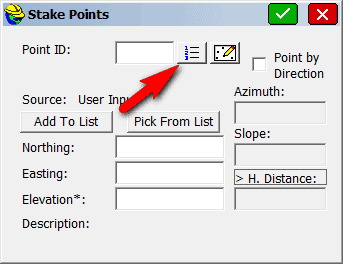
- Use the Find (binoculars) option:

- Supply your specific criteria (in the example below, I want any shot added to the list that has C1 as its description) and press Green Check when ready:
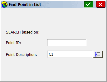
- SurvCE will scan the entire list for the Find criteria and return to the Stake Points command.
- Take the subset of points and click Add To List:
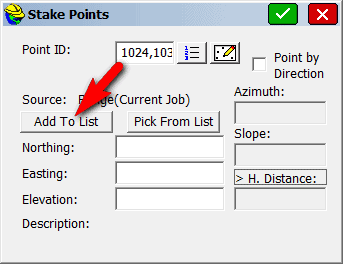
- Use the Pick From List button to access the subset list:
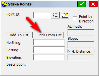
- Choose the point you're interested in and tap Green Check to stake out just the point you're interested in:
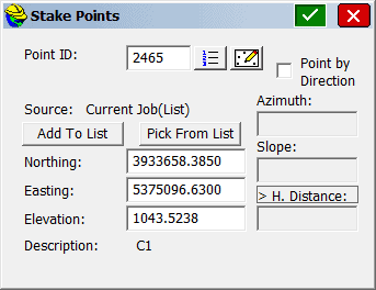
- Re-run the Pick From List option as needed to complete the staking of the point(s) from your list and/or form new list(s) as needed.
Again, other people might have other ideas. I hope this information helps.
Ladd Nelson, post: 411614, member: 307 wrote: I'm sure others may chime in but I suspect the common answer would be "It depends on what you want to do." For example, you might decide to segregate each of your "multiple layers of stakeout" into distinct and manageable jobs. If each of these jobs are in a common coordinate system, you should be able to recall or re-use a specific job localization using a toggle under Job Settings (be wary of this option if you move from job to job):

or by simply re-loading a previous localization via the Localization -- Points option:

If you don't want to have individual jobs, you'd probably want to build a point list based on some type of search criteria (e.g. range of point numbers or type of point description). You could:
- Initiate the Stake Points command and click the "Full List" button:
- Use the Find (binoculars) option:
- Supply your specific criteria (in the example below, I want any shot added to the list that has C1 as its description) and press Green Check when ready:
- SurvCE will scan the entire list for the Find criteria and return to the Stake Points command.
- Take the subset of points and click Add To List:
- Use the Pick From List button to access the subset list:
- Choose the point you're interested in and tap Green Check to stake out just the point you're interested in:
- Re-run the Pick From List option as needed to complete the staking of the point(s) from your list and/or form new list(s) as needed.
Again, other people might have other ideas. I hope this information helps.
Thank you very much for the suggestions. I will try splitting to job and loading localisation. I have the points coded by description and will try that option too. I have loaded some outline line work to help navigate graphically and have found switching to survey store points then back to stakeout centres the screen at current position. Also having duct linework helps, lots of obstructions to work around on site.
Sent from my m3 note using Tapatalk
Does anyone have notes or advice on taking a surface from Civil 3D 2017 to Survce 3.0 for set out/ checking levels. I believe this is possible, but have not managed to do this, does it work? What to export from civil 3d?
Yes, we have done it a couple of times and it's a beaut. I don't have the DC with me at the moment because it is out in the field but from memory you need to get the 3D faces from your Civil3D surface with the style set to show triangles, mouse select it, ribbon, extract objects, select triangles (or 3D faces, I'm not at a CAD machine), ok, click on one of the triangles, right click, select similar to get them all, copy clip to basepoint 0,0, paste into blank basic dwg template (acadiso). Export that to AutoCAD 2010 (SurveCE 3 can't handle anything higher), then save that dwg. Copy it to the DC SurvCE data directory. Start your job, go to Survey, Elevation Diff, load the DTM you have just created, and go for it.
Thanks Richard. I have exported a file and should be able to test at an earthworks site on Thursday. Setting out for a small vineyard irrigation reservoir.
I set out the strip footprint and any drainage. And issue control points, linework dwg, and surface xml or dwg triangulation files to the contractor for machine control. But it is nice to have the surface in the controller to be able to check any point during construction. Also will be useful for car park surfaces, and building site platforms.
kotuku4, post: 412215, member: 8886 wrote: and have found switching to survey store points then back to stakeout centres the screen at current position.
Sent from my m3 note using Tapatalk
Anyone know why this isn't done automatically in Survce? Seems like a glitch, and I've been doing the same.
From memory I think stakeout should behave such that it displays your current position plus the stakeout point then as you get closer it should automatically change zoom screens inward - this function may be one of the settings that need to be toggled in SurvCE. In regard to managing a long point list when doing stakeout, if you can remember the point number, I think there is a "find" function that can be used.


