These files are apparently what LIDAR is created from. I've been able to convert them to a point cloud (Map3D creates a single entity made up thousands of points but they cannot be manipulated like survey points) and then into a 3d surface but in image format only. Anybody have any solutions how they can be converted into a vectorized format? ie dwg, dxf, xyz, etc. Thanks!
You can convert it in ArcView, create a surface using 3danalyst, and then export to dwg.
You can import to C3D by point cloud in prospector. Bring in your .las files (make sure you only bring in returns you want, i.e. class 2 for bare earth). Then create surface from point cloud.
If you have Global Mapper you can do the same. Create elevation drid, then export a xyz text file that you can into CAD as points. Again use only the bare earth returns and class 8 map key points if they exist in the .las files
Does anyone have a "smaller" .las file I could have to look at. I may try to write a program to read them if anyone is interested. I already have the file format specs as published by ASPRS.
I imagine the files are enormous but I don't mind.
Profile email should be good.
Email away....
> I may try to write a program to read them if anyone is interested.
Before going to all that trouble, you may want to investigate lastools. No point in reinventing the wheel...
That lib is in C++ and no longer have a development environment for that.
Besides, I don't have anything else to do these days.
> That lib is in C++ and no longer have a development environment for that.
> Besides, I don't have anything else to do these days.
I can appreciate the desire to roll you own, and don't mean to discourage that. But I should point out that lastools can be plugged into QGIS (See this page). They're both available at no cost.
LASTOOLS can be a bit unwieldy if you're looking to convert LAS/LAZ files into actual terrain models for CAD or GIS and not all the lastools modules are free. I got tired of dealing with lastools and some of its limitations so I decided to role my own applications that will convert both compressed and uncompressed (binary or ASCII) LAS files into vectorized terrain models in one step. Output formats include AutoCAD DXF (poly mesh), ArcInfo ESRI grids, and QwtPlot3D grids.
I've also written a tool to convert a LAS point cloud into a DXF point cloud if all you need to do is import the points. My associates liked the tools so much that they motivated me to polish them up a bit and make commercial products out of them. If you want to learn more about the tools I've written, see my web site at: lidarwidgets.com To see the tools in action, there are several informational and tutorial videos here: lidarwidgets.com/#!page-video-tutorials
Seems to me that las files are of limited value until classified by robust programming such as Polyworks or Topodot or ....
Especially if there are point returns from vegetation which need to be weeded out to get only ground surface. Or where intensities are a valuable analysis such as differentiating traffic stripes from pavement. I process pt clouds daily and would have little use for direct conversion of a pt cloud to surface except in bare ground, stockpile or open pit mining situations.
It isn't a big problem at all and you don't need any robust programming to get LAS data that is terrain specific. You just need to tell your LAS data provider that you want only the ground returns if you're working with terrain. If that isn't possible, then just use the lasground tool to extract just the ground features from the LAS files. You can find it here: w w w .cs.unc.edu/~isenburg/lastools
and details:
lasground:
This is a tool for bare-earth extraction: it classifies LIDAR
points into ground points (class = 2) and non-ground points
(class = 1). This tools works very well in natural environments
such as mountains, forests, fields, hills, or other terrain
with few man-made objects. Note that lasground was designed for
airborne LiDAR. When using lasground with terrestrial or with
mobile data play with the '-not_airborne' option (which may
work better) or try the '-no_stddev' or '-no_bulge' flags.
I forgot to mention that there's a significant demand for terrain surface models in the remote sensing/archaeology and civil engineering fields. LIDAR surface models have been instrumental in finding new archaeological sites to be excavated in Central and South America as well as Egypt. Terrain models are also used quite a bit for road design and open pit and strip mining operations to calculate cut/fill volumes and to determine runoff direction as well as peak discharges when designing drainage structures.
I recently finished writing a freeware app that converts binary LAS/LAZ files into DXF TIN's. You can download both the OS X and Windows versions (64 bit editions only) from here: http://lidarwidgets.com/#!page-freestuff
I've recently been asked to write an app that extracts the the ground returns from a binary LAS/LAZ so that the ground terrain can be modeled independently of the vegetation and structures. It's called LAStoGround-XYZ and it will extract every ground return from your LAS/LAZ file and place it in an XYZ text file for meshing or TIN'ning. I just completed the app this week. For more info about this app and the other tools I've created, go here: http://lidarwidgets.com
I just updated the free LAStoDXF-TIN application because on some systems it failed during DXF creation. This has now been fixed and the revised version can be downloaded from here: http://lidarwidgets.com/#!page-freestuff
I've just updated a few tools for working with LAS/LAZ files and added a couple new tools. My LAS to DXF point cloud tool now converts a LAS point cloud to a DXF point cloud and preserves the classification of the laser returns. I.e. LIDAR ground returns are classified as a 2 so all ground returns are placed on layer 2 during the conversion process. Vegetation is classified as 3, 4, or 5 for Low, Medium or High Vegetation and are placed on layers, 3, 4, and 5 respectively. The batch conversion tool has also been updated to support LIDAR classification.
I've added a LAS Feature Extraction Tool. This tool will allow the user to extract/export any or all 18 LAS classifications from a LAS point cloud so that they can be modeled/mapped independently of each other. For example, all vegetation can be extracted for modeling or study, or all roads, railways and bridges can be extracted for traffic studies. Of course it also allows the user to extract just the ground returns for terrain modeling or mapping as well.
See the feature extraction tool here: http://lidarwidgets.com/#!page-feature-extraction
Another tool that I've added is called Mesh2Contour. It allows the user to create contour maps in DXF format from a mesh file that was created by my LAS to Mesh generation tools.
See an output example here: http://lidarwidgets.com/#!page-2dcontours
I've just added a new application to my software suite that will batch convert LAS/LAZ files into contour maps. Output format is AutoCAD DXF. You can get samples of the output here: http://lidarwidgets.com/#!page-samples

I've just added a new application to my software suite that will batch convert LAS/LAZ files into contour maps. Output format is AutoCAD DXF. You can get samples of the output here: http://lidarwidgets.com/#!page-samples 
I've just completed a new tool that will batch convert LAS/LAZ files into contour maps. Output format is AutoCAD DXF. You can download sample output here: http://lidarwidgets.com/#!page-samples

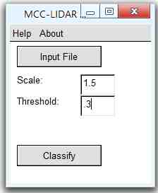
Many of my clients have been supplied with LAS and LAZ files that haven't had any point return classifications performed on them which makes it nearly impossible generate a contour map or surface model. There's a great open source tool called MCC-LIDAR which performs this function very well but it is a command line app and only compiled for 32-bit systems so the number of points it can handle is somewhat limited. There are a couple commercial products that perform ground classification but they are extremely costly and some even require annual subscriptions.
I've written a GUI version of MCC-LIDAR and compiled it for 64-bit editions of Windows and released it as freeware. It has successfully classified the ground returns on a file with 83+ million points and should have no trouble on larger point clouds/point sets.
You can download a copy here: http://lidarwidgets.com/samples/MCC-LIDAR/MCC-LIDAR-GUI-setup.exe
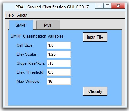
I've found that MCC-LIDAR does a very good job at classifying ground returns but it's very slow and doesn't support compressed LAS/LAZ. To that end, I've written a GUI version of the excellent PDAL automated ground classification tool. It supports compressed LAS/LAZ files and is significantly faster than MCC-LIDAR. You can download the PDAL automated ground classification tool here: http://lidarwidgets.com/samples/PDAL-GUI/PDAL-Ground-Classify-setup.exe
MacOS/OSX versions are also available. If you'd like copies of the OSX versions, contact me via my web site at: http://lidarwidgets.com/contact/


