I've been working on a program that converts geoid files from one format to another, makes excerpts of geoid files (e.g. 30 km radius from the center of Taveuni), and resamples geoid files (you can make an Alaska or Tierra del Fuego file smaller by sampling every two minutes around parallels). I'm just waiting for someone to test it on Windows, which should be no later than next week, and then I'll announce it elsewhere on the forum. I'm thinking that a file to compare geoid files (there's a discrepancy between the Lower 48 file and the Alaska file in their overlap, and I'd like to see it) would be useful. You could load a whole-earth geoid file and the NGS file, pan and zoom around on them, find a location on earth by lat-lon, and look up the geoid separation on all the geoid files at the same time. What do you think?
Taveuni?
Taveuni is a Fijian island that straddles the antimeridian. I use it as a test case in the program because some GIS software has problems with it. If you look up Taveuni on OpenStreetMap, you get two outlines: the western part in the eastern hemisphere, and the eastern part in the western hemisphere.
Here's a KML file that contains the 30 km circle around some point in Taveuni:
http://www.opengis.net/kml/2.2 ">
-179.6642864,-17.1496218
-179.6642864,-16.637355
-179.7761895,-16.637505
-179.7761895,-16.5347186
179.8880943,-16.534808
179.8880943,-16.637595
179.7761895,-16.637505
179.7761895,-16.7401812
179.6642864,-16.7400305
179.6642864,-16.9450492
179.7761895,-16.9452015
179.7761895,-17.1497758
-179.6642864,-17.1496218
I see, thought it might have been a typo. Thanks for the explanation.
ftp://ftp.ngs.noaa.gov/pub/GIS/Data/Geodesy/Geoid/
^I don't see anything in there that I recognize as a source code tarball or an executable. There's a file called "gdb", but it's only 4 kB, way too small to be the GNU debugger.
Also, that's the NGS site; I doubt it would have anything that could display the geoid files published by other countries, which are in different formats.
Those are geodatabases of the geoids that can be viewed in arcmaps or other programs that can read them. you have to create a folder put all the files inside of it in there and then rename it to raster Images of the geoids can me found here. ftp://ftp.ngs.noaa.gov/pub/GIS/NGS/Geoid/Rasters/Geoid/
^That is available only for Windows, and as far as I can tell, it outputs only .geo (which I've read of, but haven't implemented) and .gsf (which my program can write, but it calls it Carlson Geoid Separation File, and I don't know whether what FAST Survey uses is the same). Could you post a screenshot of it displaying a geoid file?
Note that on my Windows 10 64-bit system the default geoid file path is C:Program Files (x86)Common FilesAshtechGeoids, not C:Program FilesCommon FilesAshtechGeoids as indicated on the web page Mark linked.
That looks like what I'm thinking of doing; if they're doing it, it must be useful! I'll add a GUI geoid file viewer to my TODO list.
My program reads and writes .bol (my invention), .bin (NGS), .gsf, and .grd, and reads the US NGA binary format, which has no extension. It only reads the last one because it's a whole-world format, so one can't write an excerpt in that format. Adding new formats is a simple matter of programming.
Mark Silver, post: 437200, member: 1087 wrote: Exports .GSF, .GEO and .CSV.
SurvCE and FASTSurvey are identical other than versioning and the initial splash screen.
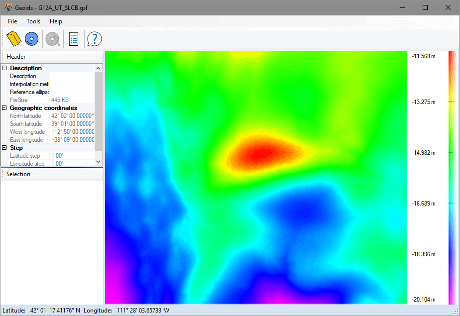
Here is the GEOID around Salt Lake City:
I spent quite a few summers in the "red spot" with the USFS (1969-1975 or was it 76???)
😉


