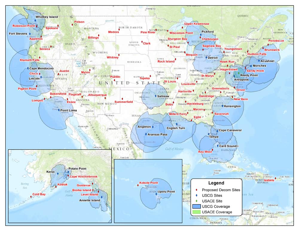
The feds are proposing to decommission 62 of 84 NDGPS sites. I do have a coast guard beacon receiver, which I have not used in many years. I would not care if the broadcasts go away, but I hate to lose any CORS...
A Federal Register Notice has been issued regarding the Nationwide Differential Global Positioning System (NDGPS). A number of factors have contributed to the declining use of NDGPS and, based on an assessment by the Departments of Transportation and Homeland Security, as well as the U.S. Army Corps of Engineers, there is a proposal to shutdown and decommission 62 DGPS sites, which will leave 22 operational sites available to users in coastal areas.
Termination of the NDGPS broadcast at these sites is planned to occur on January 15, 2016. A map of the proposed changes to NDGPS coverage can be found athttp://www.navcen.uscg.gov/images/dgps/FRNDGPS.jpg
Widest dissemination of this notice is requested in order to ensure that comments are collected from users impacted by this change. Comments are due on or before November 16, 2015. The link to access the FRN and provide comments is as follows: https://www.federalregister.gov/articles/2015/08/18/2015-20401/nationwide-differential-global-positioning-system-ndgps
Don't care about the Michigan ones. MDOT has dozens and dozens of CORS around us that are much better. Back when I started using static, I tried using the Pickford and Cheboygan CORS sites. Every time I did multi days of observations, the vectors to those antennas would fail. A very good GPS salesman in this state once told me that he actually modeled movement in the metal towers that the antennas were mounted on. Navigation - it may be useful, but as high-precision CORS, I gave up on them long ago. Take the $$ and dump it into the ground segment of GPS and that that finished.
True, most places have plenty of CORS so that one gone wouldn't be missed. I hope they take into account the areas that DON'T have a lot of CORS around. I imagine the transmission of corrections is a costly endeavor. Hopefully they could keep a few of the critical ones as simple CORS.
In both Oklahoma and Oregon the DOTs are maintaining a statewide network of CORS. I don't think these few will be missed. Not in those 2 states. If the loss of these sites makes a hole in the coverage the DOTs should take over the operation them.
I use the Chico and Klamath Falls CG Beacon for GIS type work.
I would like to know the exact amount of money spent each year on this station.
-----------
I haven't used these in many years for GIS type stuff, have used them occasionally as a CORS, BUT I don't think for most surveyors these are critical, progress in technology is inevitable and while sad, I think these will probably fade away in January. Never thought about movement in the tower, but for precise work that is something that probably should be considered when you download CORS data (hopefully few to none are used by OPUS), I guess we just expect CORS to be solid without too much thought.
SHG
Shelby H. Griggs PLS, post: 333394, member: 335 wrote: I haven't used these in many years for GIS type stuff, have used them occasionally as a CORS, BUT I don't think for most surveyors these are critical, progress in technology is inevitable and while sad, I think these will probably fade away in January. Never thought about movement in the tower, but for precise work that is something that probably should be considered when you download CORS data (hopefully few to none are used by OPUS), I guess we just expect CORS to be solid without too much thought.
SHG
They are used for my specific area as they are closer then many MDOT CORS. They always seem to be automatically selected, then I had to go back and un-select them every time. Even with using a profile, it seemed like it was always easier to just process it myself, which I always do now.


