Questions after a survey disagreement

  • Questions after a survey disagreement

    Posted by Jasoninmaine on January 13, 2023 at 3:32 pm

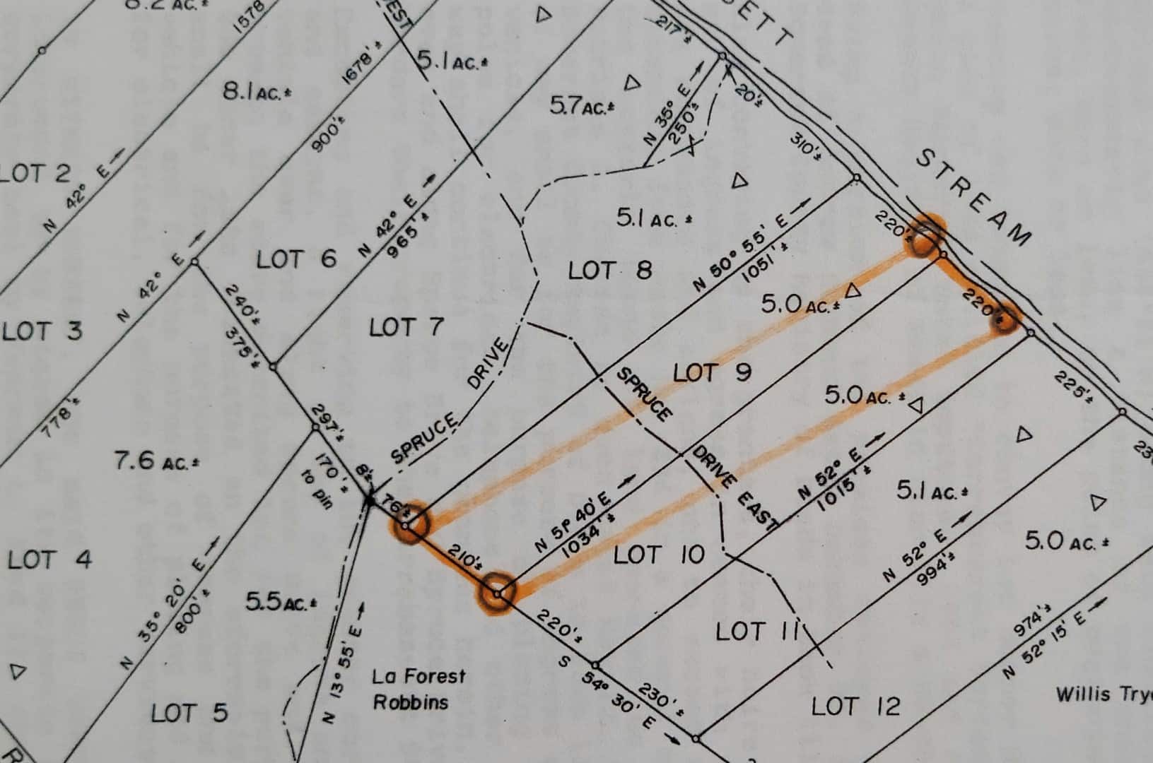
    Hi, We have purchased a 5 acre lot inside a professional and recorded subdivision from 1984. All neighbors gathered and compared each corner to have a rough draft of an idea where each lot was situated prior to an ordered survey. We all understood this would be a rough draft only and can vary within reason. 

    After the survey was completed we found that 2 pins didn’t move and 2 others moved significantly changing not only the lot I purchased, but it changed the whole sub division diagonally cutting each parcel about 125 feet. I’ve included a pic for reference.  

    The surveyor states that he used True North vs Magnetic. 

    Found several pieces of metal that they ( felt ) would be a starting point for a corner pin on stream side of land.

    Could not produce coordinates and or degrees of angle or formula to show how they came to the position of pins with the exception of the starting point that matches perfectly.

    We as the lot owners will be challenging the surveyors findings based on no explanation of how they found each pin, coordinates, degree, and should have been done using magnetic with declination. 

    Can anyone recommend a tool or hand held electronic device to use in the field that would help with magnetic and degree of angle vs just using a compass? Looking to use tool that wont be quickly dismissed and holds some clout. We have used 6 different location apps from IPhone, Android, and GPS and all fall in line perfectly to the sub division map. 

    Also, if anyone can give advise on what questions I can use to challenge without sounding like a moron… 

    Thank you in advance for the help!  Jason


    peter-lothian replied 1 year, 2 months ago 22 Members · 30 Replies
  • 30 Replies
  • jflamm

    jflamm

    Member
    January 13, 2023 at 6:31 pm

    Is there a basis of bearing shown on the subdivision plat?

  • Norman_Oklahoma

    Norman_Oklahoma

    Member
    January 13, 2023 at 6:45 pm

    The basis of bearings being true or magnetic is really unlikely to be a source of your problem. The bearings given are really just a manner of annotating the angles between the various lines. Those angles are far more relevant than the particular bearings. 

    Of paramount importance is the position of the monuments that were set in 1984. Those will trump any mapped dimensions. But it looks like your orange lines are connecting diagonally across the intended parcel. I’m not sure what’s up there. It could be there are more monuments that need to be found. 

  • jph

    jph

    Member
    January 13, 2023 at 6:48 pm

    I guess I’m confused at how you know this.  Who drew the orange lines on that plot?  You and your neighbors, or a surveyor you hired? 

    Did you have it surveyed?  Your 2nd paragraph begins, “After the survey was completed…”.  If you did hire a surveyor, did he produce a plan or worksheet of his findings? 

  • Williwaw

    Williwaw

    Member
    January 13, 2023 at 7:24 pm

    Appears magnetic north has been confused with true north which is what the subdivision most likely references.

    You can calculate the magnetic declination for your area in 1984 and today here

    Simply apply this correction angle to your compass to get true north and I think you will most likely find that things line up. 

    At the end of the day, it’s the monuments that will have the final say in where the lines are on the ground. 

    Good luck!


    Willy
  • bill93

    bill93

    Member
    January 13, 2023 at 7:33 pm

    The basis of bearings can’t change the angles, as mentioned above.  The orange box does not have the same angles as the plat. I can see no way the surveyor could justify that.  I think the orange box uses 2 pins from one end of the lot and one pin from the other end, with a pin from the adjacent lot.


    .
  • murphy

    murphy

    Member
    January 13, 2023 at 7:43 pm

    Maine requires a contract be in place prior to the commencement of a survey.  What was the scope of services described in the contract?  Were you to be provided with a report of survey or a plat (map showing boundaries)?

    Surveys are a professional opinion and are not immediately binding. Landowners always have the ability to agree on the location of shared boundaries, so don’t get into a panic.

    PLSs are very busy right now, so it might be the case that yours just did not have, or make, the time to explain what is likely a complicated issue.

    Myself and others on this board are licensed in Maine.  The more factual documents you can provide, the better we can help.


  • dave-karoly

    dave-karoly

    Member
    January 13, 2023 at 7:49 pm

    Magnetic Declination in Maine is roughly 15?ø west.

    I have no idea how things are done in Maine but nothing from the 1980s would be referenced to magnetic north out here. In fact I donƒ??t think magnetic north was ever widely used.

    If the map bearings are magnetic but they were run out as true the orange lines are roughly what would happen. I doubt that is the case though.

    Only the Surveyor that did the recent work can explain their findings; it can only be presumed that they are correct because they are an expert and you are not. Hilly and brushy terrain can make things look significantly off when they arenƒ??t.

  • rover83

    rover83

    Member
    January 13, 2023 at 8:07 pm

    We can’t really say anything about the survey without seeing it. Erase or blur the firm’s name and the surveyor’s stamp, etc.. and post it up here please.


    “…people will come to love their oppression, to adore the technologies that undo their capacities to think.” -Neil Postman
  • jph

    jph

    Member
    January 13, 2023 at 8:21 pm

    @dave-karoly 

    I don’t work in Maine, but can tell you that magnetic north is used throughout VT, NH, and rural MA

  • jph

    jph

    Member
    January 13, 2023 at 8:25 pm

    If those are found irons/pins/pipes, in orange.  Why is the assumption that they’re the rear corners of Lot 9, and not rear corners of Lot 10 instead?

  • michigan-left

    michigan-left

    Member
    January 13, 2023 at 9:18 pm

    Maine is really tough to find anything. Maybe someone else knows how to get the subdivision plat map, but I can’t seem to find it.

    Carrabassett Stream Subdivision; Somerset County, Anson, Maine

    Southwest corner of the 2015 tax map: 

    https://ansonmaine.town/wp-content/uploads/2015/10/Map-23.pdf

    Is it normal on a final subdivision plat in ME to show the lot dimensions as “220′ +/-“?

  • jflamm

    jflamm

    Member
    January 13, 2023 at 9:20 pm

    I wonder if some meander corners were set along that stream and that’s what they found.  

  • duane-frymire

    duane-frymire

    Member
    January 13, 2023 at 9:55 pm

    You will lose.  You need to find an opinion of another surveyor that disagrees.  I have no idea what’s going on without actually surveying it.

  • On_Point

    On_Point

    Member
    January 13, 2023 at 11:59 pm

    Wow, thatƒ??s quite the shift in lot lines. Iƒ??m kind of curious what that does for the lots on each end? I agree that the angle should be the same regardless what you call north. You could set your survey to zero azimuth facing east, west, south, etc. and it would still come out the same angles relative to each other and look the same on paper just different rotation as a whole. 

  • cee-gee

    cee-gee

    Member
    January 14, 2023 at 12:44 am

    Here’s the whole plan. As a Maine licensee I note that it does not state specifically whether it’s oriented to True or Mag. or anything else. Mag was in common use in this area in 1984, and likely the basis of most of the survey plans done about then, and I believe there’s a Maine Law Court decision somewhere that ruled that Mag. is to be presumed as the basis of survey bearings unless something else is explicitly indicated. Our Board’s website says the surveyor who did the plan let his license lapse in 1995 and thus is evidently retired, otherwise I would have urged Jason to get him into the picture.


  • Mathew Stuesser

    Mathew Stuesser

    Member
    January 14, 2023 at 1:48 pm

    @norman-oklahoma I wish there was a like button so I could like your comment lol.

  • GaryG

    GaryG

    Member
    January 14, 2023 at 2:42 pm

    WOW ! 

  • rover83

    rover83

    Member
    January 14, 2023 at 3:03 pm

    Good on @cee-gee for posting the full subdivision/plan.


    That being said, we are all still in the dark about what, exactly, the OP is “challenging”.


    “…people will come to love their oppression, to adore the technologies that undo their capacities to think.” -Neil Postman
  • On_Point

    On_Point

    Member
    January 14, 2023 at 5:55 pm

    The more I look at the plat the more I agree with an above comment that itƒ??s likely there is an issue with the original survey or monuments. I think if I were surveying one of those lots and run across the discrepancy  after all this time, I would be inclined to hold the original survey corners (if all the bearings and distances agree with the other lots) since itƒ??s been the accepted boundary for all these years unless otherwise decided in court and just make note of the discrepancy and evidence suggesting a discrepancy on the plat and description. When it all comes down to it courts generally err on the side of whatƒ??s been established as boundary in the past.(not sure if I explained that very well)

  • rover83

    rover83

    Member
    January 14, 2023 at 8:03 pm

    @on_point

    The more I look at the plat the more I agree with an above comment that itƒ??s likely there is an issue with the original survey or monuments.

    I don’t know how anyone can say anything about the state of the lot or the original subdivision. That plat is the only hard piece of evidence that we have seen so far. Absent any other evidence, there’s nothing to analyze.


    “…people will come to love their oppression, to adore the technologies that undo their capacities to think.” -Neil Postman
Page 1 of 2

Log in to reply.