

Ask A Surveyor
Public Group
Public Group
Active a day ago
If you are a landowner seeking advice from surveyors, please post your questions and issues here.... View more
Public Group
Organizer:
- Organized by
-
Group Description
If you are a landowner seeking advice from surveyors, please post your questions and issues here. DISCLAIMER: All surveying-related questions should be consulted with someone licensed in their jurisdiction and hired for professional services. The answers provided here are not to be construed as official advice from a professional that you would otherwise obtain in your local area.
Question about how to read property Metes and Bounds
Question about how to read property Metes and Bounds
Posted by fylopian on June 20, 2023 at 9:32 pmMy property is not platted and the property is in Torrens. The metes & bounds listed on the Property Title is described as:
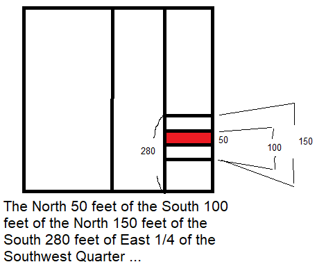
The North 50 feet of the South 100 feet of the North 150 feet of the South 280 feet of East 1/4 of the Southwest Quarter of
the Northwest Quarter of the Northeast Quarter of Section 20, Township 28, Range 24.I’m having trouble trying to read what that means. Is anyone able to help me translate? I found one property pin and i’m trying to find the other, but am not sure what the dimension of my plat is. I think maybe 50 feet.
rplumb314 replied 7 months, 2 weeks ago 10 Members · 13 Replies- 13 Replies

First I’d like to say, this is merely advice and not intended in any way to give you actual dimensions that can only be achieved by having a licensed surveyor in your area perform a survey of your property.
The key is to actually read aliquot descriptions backward. Start with the entire Section, which for general understanding is one square mile (they hardly ever are in actuality) then connect between the opposing midpoints, this creates the quarter sections. Then in your case, do the same for the NE quarter, then again on the NW quarter of that result. Then divide the SW quarter of that into 4 equal portions vertically (North-South lines). On the Easternmost of them make a parallel line 280′ North of the South line, then 150′ South of that line, then 100′ North of that line, and lastly another 50′ North, your property is bounded an the South by the last line created and on the North by what ever line is 50′ North of that. the parcel is approximately 50′ North – South by 165′ East – West. For a more accurate dimensioning you will need to hire a local surveyor who will make an opinion on your boundaries by weighing any found evidence, what the deeds around you all say and if there are any surveys in the area plus any surveys and monuments that would have been set by the GLO or BLM.

That is quite a description. The fun part of decipering such descriptions is to draw a picture while working from the end of the description towards the start of the description.
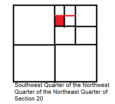
Start by drawing a very large square. Consider the top of the square to be north and the bottom to be south, with west to the left and east to the right. Draw a line from the midpoint on the north line to the midpoint on the south line and then do the same from the midpoint on the west to the midpoint on the east. You have now created the four quarters of the section. Everything further occurs in that northeast quarter.
Again, draw lines in the northeast quarter as you did for the entire section until you can see the NW quarter of that NE quarter. Everything further occurs in that northwest quarter of the northeast quarter
Use the same process to find the southwest quarter of your northwest quarter of the northeast quarter
Keep moving along by taking one step at a time towards the start of the description by further dividing your illustration. Eventually, you will come up with a tract that is 50 feet north-south by about 165 feet east-west. The final numbers may turn out to be slightly different than what the deed says. Long deeds, such as yours, suggest there have been many changes in ownership since someone owned the entire northeast quarter of the section.

My answer duplicates some of a previous one, but I’ll let it stand as I typed it.
If I read it right, that’s nominally 165 ft east-west and 50 ft north-south, but the actual dimensions may differ a little depending on the deed history and measurements made in the past that weren’t exact. When it was entered into the Torrens system there may be further details recorded.
What state is this in?
That’s one of the more complicated descriptions you might encounter for a nominally rectangular parcel. You need to read it backward. Start with a sketch of a square mile section of 640 acres and divide it down identifying the NE quarter (160 acres), then out of that quarter its NW quarter (40 acres), etc. down to 2.5 acres (if I did it right).
Then in that parcel label the south 280 ft, and within that the north 150 feet, etc.
.Where things grow complicated is that sections are never perfectly square nor perfectly 5280.00 feet by today’s measurements. What we call the Public Land Survey System had been around since 1785. Thus, measurements made over 200 years ago should not be considered to be exactly the same number as we would attain today using modern equipment. This is why we have suggested that the final measurements of your tract will not be exactly 50.00 feet by 165.00 feet and perfectly rectangular. Knowing your location provides us with a good guess as to the measurement practices of the time frame when your section was created.

The key to understanding a description of this type is to read it backwards.

I found one property pin and i’m trying to find the other, but am not sure what the dimension of my plat is. I think maybe 50 feet.
The question is also: What is the evidence that you have that indicates that you found a property corner?

@jitterboogie The property pin that i found was about 14.5 ft from the curb on the northeast side and is right next to my neighbor’s driveway.
i think ultimately i’m going to get a property survey completed I was just really struggling with how to read the metes & bounds, but appreciate all the comments on how best to read. Also appreciate the translation that the N-S is likely ~ 50 ft.

E-W is 165 + –
Very good illustrations, Norm.

I was just really struggling with how to read the metes & bounds,
It may help you to know this is not a metes and bounds description. In the PLSS (Public Lands Survey System) this aliquot description tends to be more accurate than metes and bounds for the PLSS because the aliquot description derives from the original descriptions from surveys.
A metes and bounds description of a PLSS aliquot part frequently describes a different parcel than intended.
Get a surveyor to clarify things for you.
Good luck.

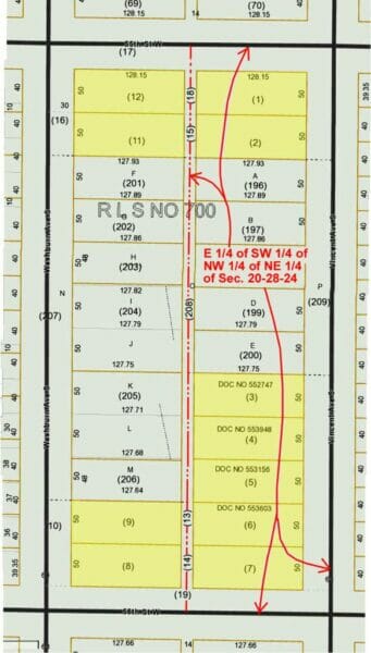
This is a late post but might be of interest to someone.
In 30-odd years of working in the Twin Cities, I saw a great many blocks of this sort, and surveyed a dozen or so. There are hundreds of blocks like this in St. Paul and its suburbs. They are rare in Minneapolis; in fact this might be the first one I’ve seen there.
What evidently used to happen, back in the 1940s and earlier, was that a landowner would divide some acreage up into parcels the size of ordinary city lots and sell them; but instead of spending money out front to plat the entire tract, he would sell them individually using PLSS descriptions like the one the OP has. That way he could pay the surveyor for one lot at a time, as they sold. Of course this practice would not be allowed today.
In this block, as is usual in these cases, the streets and alleys were dedicated by separate documents and/or City Council actions, since there was no other way to do it. Here the OP’s parcel as originally described had 7 feet taken on the rear and 30 feet on the front for rights of way.
In the marked .pdf attached below, all the highlighted parcels have PLSS descriptions like the OP’s. The white area in the middle of the block is a Registered Land Survey, a sort of simplified plat used for Torrens property in Minnesota.
When surveying in a block like this, it’s important to remember that the block has been surveyed before; and also that the entire block was most likely run by the same surveyor. The original surveyor’s footprints will be there and should be followed. If you run the descriptions as they are written and bring them in from the PLSS corners, you might disagree with all the occupation lines by several feet.
A colleague of mine calls these things “metes and bounds plats.” I think it might be better to call them “piecemeal plats” or “de facto plats.”


Log in to reply.