

Ask A Surveyor
Public Group
Public Group
Active a week ago
If you are a landowner seeking advice from surveyors, please post your questions and issues here.... View more
Public Group
Organizer:
- Organized by
-
Group Description
If you are a landowner seeking advice from surveyors, please post your questions and issues here. DISCLAIMER: All surveying-related questions should be consulted with someone licensed in their jurisdiction and hired for professional services. The answers provided here are not to be construed as official advice from a professional that you would otherwise obtain in your local area.
Looking to find my property pins.
Looking to find my property pins.
Posted by Goonies85 on April 20, 2019 at 1:05 am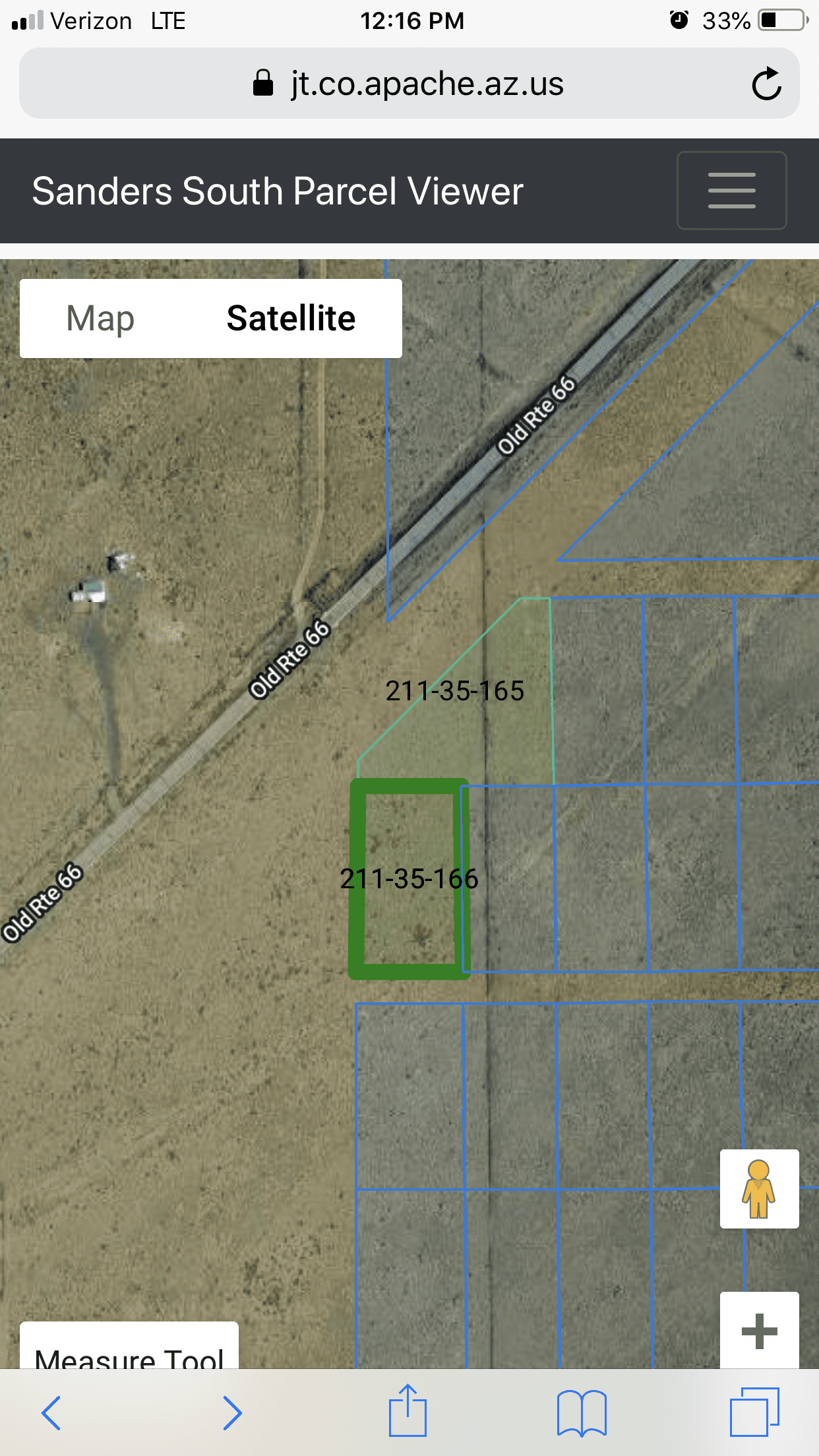
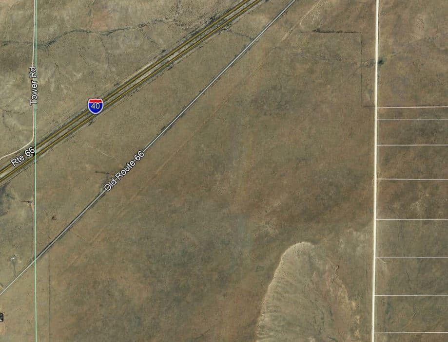
I am trying to find my property pins on a rural subdivision that hasn??t been developed. From the county??s GIS it shows my property with 250ft of Old RT 66. I have the subdivision plat but it doesn??t show old rt 66 on it. Shows only the large highway I40. I would really love some gps coordinations to get close to my pins to find them with a metal detector. Thanks.
Norman_Oklahoma replied 5 years ago 15 Members · 22 Replies- 22 Replies


Step one. Which state are you in?

Apache County, AZ

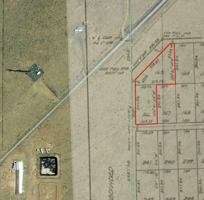
The plat says Petrified Forest Estates No. 4, Apache Co., Arizona. NE 1/4 and S 1/2 sec 30 T19N R24E and ….
My question is, what makes you think anyone set corner monuments for all those undeveloped lots? Nowadays it would be more likely, but in the 70’s maybe not so much. I don’t see circles at the intersection of lot lines, only at the outer corners. If there are no monuments, you will need a licensed surveyor to put some in for you to find the lot.
.A quick search shows that you can buy all the 1.08 acre lots you want around there for $7500 each. Some private sales look cheaper. But what would you do with it? Are there any utilities installed, like water, sewer, electricity, gas, communications?
https://www.zillow.com/homedetails/Liberty-Rd-Holbrook-AZ-86025/2086645668_zpid/
.
I was told but the county office that they have found pins on the side of the dirt road lots. A few people have built on lots on the dirt road side.
Electric near about 300ft Water is not and no sewer. So going to drill a well and setup a septic.

The wording of the declaration suggests to me that this is a protracted plat, and thus the individual lots are not marked out on the ground. There may be more detail on the bottom of the map, which you haven’t shared. It was platted in 1967, long before any GPS satellites were launched. So any direct ties to “GPS Coordinations” are not there.
Possibly there are some survey records of nearby lots that someone else has had done. If close enough you could tape of those to get an idea of just which slice of desert is yours. But only an idea.
I suppose something could be scrubbed off the GIS, but that would not be definitive, to say the least. The GIS lines are put there to enumerate lots, not to locate their boundaries. Such coordinates might take you to a point in the desert from which you might be able to see your individual lot, but it would not be definitive in any way.
You need a surveyor. The good news is once you have your lot surveyed it will be more valuable that the hundreds of other unsurveyed lots out there.

Why are there likely no corners?
Cause it’s cheaper to just buy an extra acre, and a 100′ tape from Lowe’s, and just guess those corners…. Ya got extra land, so if you are wrong by 50′ it ain’t gonna matter…..
(How they do it around here…)

I doubt any of the lots have monuments in 1967.
The ones occupied may have been surveyed.
According to the satellite view, I doubt you will find any monument on that lot.
Your best way to be sure would be to hire a licensed surveyor.
goodluck
You asked for the coordinates. The coords that exist, are probably estimated from a GIS. Could be within 30′, could be off by hundreds of feet.
Get it surveyed, then, you can find the coordinates.
I had a rather contested boundary. One of the issues for the landowner I was working for was they had to do some environmental assessments. I gave them all the boundary data in state plane format.
They hire an environmental firm to do some soil testing. The young ‘experts” go to the county GIS and download a file for the area plotting the boundaries into their handheld. Next thing is they jumped a boundary fence and began digging in farmer Smith’s hay meadow.
Farmer Smith wasn’t too happy, they told him his field was the other landowner’s property (big surprise it wasn’t).
They stayed out of jail by the skin of their teeth.
The reason they didn’t use my coordinates is cause they “had” to use “official” data which is company policy.
Point being is that, yes we can cobble some coordinates together for you, from “official” web sites, and send you out to the field with them in your handheld, but I don’t think anyone here will do that. It would be very unprofessional, could I get “close”, probably if I took the time to download photos and geo-reference them into a good database and analyze the plat compared to occupation and such, but I won’t do it.
If you can’t do it yourself, you shouldn’t do it yourself.

Ran across some of this guys work about 25 or 26 years ago North of Douglas, AZ. If I remember correctly, it was pretty iffy.

There’s a guy in Redmond WA; what was his name again..?
That’s what he did; sold that to you for about 30 bucks. His dad taught him how to read legal descriptions; so that made him an expert. He called it a survey but put a disclaimer on it; said it was only accurate to about 30 feet. Mainly for people who hunted private land, so you knew where to hunt, or not.
He’s been called out, here, a few times. I even think the board may have shut him down.
You could even try the onxmaps App. https://www.onxmaps.com/ It will show you boundaries any where in the lower 48…
I hope everyone has a great day; I know I will!I also heard a story of a developer/realtor in Washington that would lay out subdivisions with his handheld, then sell the land. I guess it worked for a while,,,,until people tried to figure out what they owned.
I can just imagine how far off some of these online maps really are, we recently finished a public land boundary and it’s still messing with the computer geeks a year later, they can’t understand why we are off the real location.
A bit of knowledge of how GIS coords would be helpful.
They are developed from creek, road, ridges, or other viable objects, from aerial photography. And, some of this photography is built from survey control, and some is nearly not. Meaning, that with aerial photography, many thousands of pics are taken, from various elevations above ground. All this gets compiled, into one, removing distortion, due to terrain, camera focal point, and such. However, ground survey control, is sparse, non existent, or out of date.
Stuff can “look right”, but contain large errors, due to the whole town being 50′ or 100′ too far NW. That is, the numerical values, and the ground points are not well related.
Many genuine, and GOOD surveys are not tied to a world coord system. They are are only coherent locally, against themselves. When compared to State plane coord systems, they are many miles off. And, rotated to a local system.
So, you want coords, but unless you really understand WHERE these coords come from, you are rolling dice, that will give you many answers.
Many jobs of the past are performed upon a local coord system.
Get a good survey.
Even if you find a few pins…. They may be:
Goat stakes
Disturbed
Or scrap metal.
Somebody has to climb the hill, get a survey, and get solid connections between old original title boundaries, and your deed. Then, relate this to a world coord system. (Often this last step gets skipped). Now a days, somebody with proper tools can do this pretty fast. But, not all surveyors are proficient with it.
N

I’d look at the plat to the East, the block or lots seem to be a bit more defined. Also, the dark jog along Adamana road looks like it might match up with the plat. Could give you a place to start at least.
just for fun, of course. I threw this together
That??s pretty cool.

$7500 for a lot? I don’t think I would mobilize on this survey for less than $10k. I suppose a good deal always has its own costs.
-All thoughts my own, except my typos and when I am wrong.
Before you spend a nickel do some research to see if any wells have been drilled in the area and how deep’s the water. If you need to go down 300-400+’ for water, the price of that land will be chump change compared to the price of drilling a well with no guarantee you won’t be buying a duster. Without water the land’s not worth much.
Willy


Log in to reply.