Help Defining Property Lines Needed Pleased

  • Help Defining Property Lines Needed Pleased

    Posted by Homer Allman on April 11, 2019 at 1:58 am

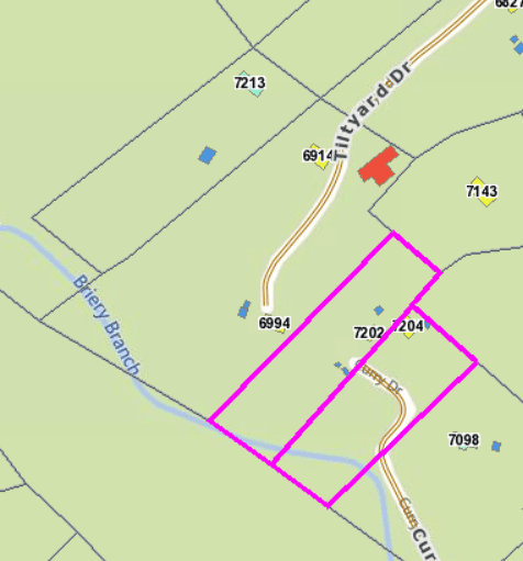
    I need help determining the property line from the information I have from the deed.  We own the property with the 6994 & 6914.  The line we’re interested in is that pink one that encompasses the 7202.  

    The 6994 property deed says “an axel found beside a corner post, a corner of (owner) thence with (owner) line fence and the extension of line across Briery Branch S48 deg 03′ w 610 feet to an iron pipe”.  We located the axel in the northeast corner of the 6994 property.

    The 7202 property deed says “beginning at a stone; thence, s47 w 35.15 poles crossing Briery Branch to a spruce pine stump, thence N53 1/2 w 150 feet, thence, N47 E @35.5 poles parallel with the first of the aforesaid cause to a stake making a new line to a new corner; N42 W150 feet to the point of the beginning containing 2 acres more or less”.  

    My question is on the 7202 property where it references the spruce stump, which property line on the 7202 property is the stump located – eastern or western?

    daniel-ralph replied 5 years ago 4 Members · 8 Replies
  • 8 Replies
  • peter-lothian

    peter-lothian

    Member
    April 11, 2019 at 12:42 pm

    Looks like somebody mis-typed one of the E or W bearing quadrants on the short lines at some point (or mis-typed a N to S quadrant, or possibly both errors). You can trace the deed history back to when the description was first used. Somewhere in that chain of deeds you might find where the quadrant was changed. That would then provide the answer to your question. The change was probably unintentional. We call this a scrivener’s error, when the person copying a description from one deed in to a new deed makes a simple typing mistake.

  • dave-karoly

    dave-karoly

    Member
    April 11, 2019 at 1:15 pm

    If the second course should be flipped to S 53-1/2?ø E then the stone and spruce pine stump is in the 7202 westerly boundary.

    If the second course is correct and the fourth course should be flipped to S 42?ø E then the stone and spruce pine stump is in the 7202 easterly boundary.

    35.5 poles equals 585.8 feet and 35.15 poles equals 580.0 feet.  It’s also of interest to note the mixture of units, poles north and south and 150 feet east and west.

    It is most likely the error is in the fourth course from looking at the bearings.

  • Homer Allman

    Homer Allman

    Member
    April 11, 2019 at 10:59 pm

    thank you guys so much for the help!  it’s pretty confusing but we’re working through it


    any thoughts on how accurate the surveys from the 50s were?  

  • dave-karoly

    dave-karoly

    Member
    April 12, 2019 at 12:01 am

    They very widely depending on State and County. Metropolitan subdivisions can be very accurate but rural property could be very roughly done.

  • daniel-ralph

    daniel-ralph

    Member
    April 12, 2019 at 12:40 am

    Mr. Allman,

    It appears to me that  the spruce stump referenced in the description is the southernmost corner of the 7202 parcel which may be south of the waterway. The stone that is referenced appears to be the easterly most (northeast) corner of the 7202 (Curry) property. 

    A pole is commonly 16.5 feet in length. 

    I have no opinion why the discrepancy with the GIS map and the dimensions cited. it would be helpful to us here on this forum to have an image of the complete descriptions so that we can evaluate the whole picture. 

    A survey done in the 1950s would be more precise than the (any) GIS map that you provided and likely would show more clues as to where the boundaries are. If you have one, it would be helpful to us if you included that with your question. 

  • Homer Allman

    Homer Allman

    Member
    April 12, 2019 at 1:45 am

    there is a patch of spruce trees in the southwestern corner area so you are probably correct.  they appear to be the only ones on the property.  but how long does a spruce stump last since it’s been 1953 when the deed was made?


      the info we listed above was all we were able to obtain from the court house.


    thanks.

  • peter-lothian

    peter-lothian

    Member
    April 12, 2019 at 2:45 pm

    The deed you took the description from may have been made in 1953, but not many people were measuring land using poles as distance units then. It is likely that the description was copied over from successive deeds. My guess is that description originated sometime in the 1800’s, and if so, the stump was probably rotted away by the time 1953 rolled around.

  • daniel-ralph

    daniel-ralph

    Member
    April 12, 2019 at 3:54 pm

    Mr. Allman,
    You will have to travel to the county seat and visit the office where the records are kept. They should be able to provide you with complete copies of the deeds that you need. Alternatively, perhaps try a title company for this information.
    I would guess that whomever wrote the words for the 7202 description was working with a larger parcel. The combination of feet and poles on one description is the clue there.
    While surface evidence of the spruce stump may be hard to see it may be recoverable. If the land is undisturbed, there will be below grade evidence of it that may be discovered by careful excavation in the area that matches the location determined by distances from other found objects or witness testimony. Surveyors have been recovering cedar posts, rock piles, stones and other not-obvious objects for generations in order to re-establish corners.

Log in to reply.